Country:
 Malaysia
Region:
City:
Latitude and Longitude:
Time Zone:
Postal Code:
IP information under different IP Channel
ip-api
Country
Region
City
ASN
Time Zone
ISP
Blacklist
Proxy
Latitude
Longitude
Postal
Route
IPinfo
Country
Region
City
ASN
Time Zone
ISP
Blacklist
Proxy
Latitude
Longitude
Postal
Route
MaxMind
Country
Region
City
ASN
Time Zone
ISP
Blacklist
Proxy
Latitude
Longitude
Postal
Route
Luminati
Country
MYASN
Time Zone
Asia/Kuching
ISP
BGP Network Limited
Latitude
Longitude
Postal
db-ip
Country
Region
City
ASN
Time Zone
ISP
Blacklist
Proxy
Latitude
Longitude
Postal
Route
ipdata
Country
Region
City
ASN
Time Zone
ISP
Blacklist
Proxy
Latitude
Longitude
Postal
Route
Popular places and events near this IP address
Garden International School
International school in Kuala Lumpur, Malaysia
Distance: Approx. 547 meters
Latitude and longitude: 3.16777778,101.64777778
Garden International School (GIS) is a private, co-educational international school in Mont Kiara, Segambut, Kuala Lumpur, Malaysia. Founded in 1951, GIS is one of the oldest and most prestigious private schools in Malaysia. GIS is part of the Taylor's Education Group and a member of the Federation of British International Schools in Asia (FOBISIA).

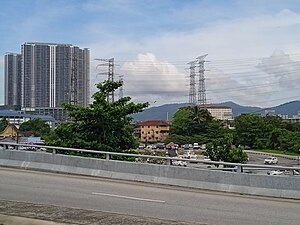
Mont Kiara
Suburb of Kuala Lumpur in Segambut, Federal Territory of Kuala Lumpur, Malaysia
Distance: Approx. 656 meters
Latitude and longitude: 3.17083333,101.65388889
Mont Kiara, often stylized as MK, is an affluent suburb at the northwest of downtown Kuala Lumpur, Malaysia, in the constituency of Segambut. It consists mainly of high-rise residential condominiums and office complexes which were mostly developed by UEM Sunrise Berhad, a well-known property development arm of UEM Group. It is located in the heart of Klang Valley, halfway between Kepong and downtown Kuala Lumpur.
Segambut
Place in Federal Territory of Kuala Lumpur, Malaysia
Distance: Approx. 2025 meters
Latitude and longitude: 3.18333333,101.65
Segambut is a sub-district in Kuala Lumpur, Malaysia. The federal constituency represented in the Dewan Rakyat is Segambut (federal constituency). From the high-end condominiums of Mont Kiara and Sri Hartamas to the middle-class areas of Taman Sri Segambut and Bandar Manjalara, and the rural areas of Segambut Dalam and Kampung Sungai Penchala, the Segambut district has a diverse population base.

Damansara Heights
Upscale suburb in Kuala Lumpur, Malaysia
Distance: Approx. 1417 meters
Latitude and longitude: 3.15435833,101.65859167
Damansara Heights (Malay: Bukit Damansara) is an upscale suburb in western side of Kuala Lumpur, Malaysia, located five kilometres away from the city centre. The suburb falls under the Segambut district and its parliamentary constituency. It is a sought-after residential and commercial address in Klang Valley.

Penchala Tunnel
Distance: Approx. 1774 meters
Latitude and longitude: 3.1647602,101.6360446
The Penchala Tunnel is a highway tunnel in Kuala Lumpur, Malaysia. It is the widest highway tunnel in the country. This 700-metre tunnel, located on the Sprint Expressway's Penchala Link, connects Sungai Penchala to Mont Kiara.

Perdana University-Royal College of Surgeons in Ireland School of Medicine
Distance: Approx. 2072 meters
Latitude and longitude: 3.15335539,101.66634034
The Perdana University – Royal College of Surgeons in Ireland School of Medicine (commonly known as PU-RCSI or Perdana-RCSI) is one of the six schools of the Perdana University located in Damansara Heights, Kuala Lumpur. It was established in 2011. The first batch of students was enrolled in 2011 and graduated in 2016.
Seri Hartamas National Secondary School
National secondary school in Desa Sri Hartamas, Federal Territory of Kuala Lumpur, Malaysia
Distance: Approx. 1004 meters
Latitude and longitude: 3.1576518,101.6471263
Seri Hartamas National Secondary School (Malay: Sekolah Menengah Kebangsaan Seri Hartamas) is a co-educational, public secondary school currently located at Sri Hartamas, a suburb of Kuala Lumpur, Malaysia. Established in 1992, SMK Seri Hartamas was the first co-educational public secondary school in the Sri Hartamas area. The school was initially located at Taman Sri Hartamas before moving to its current location at Desa Sri Hartamas in 1999 (to accommodate the rising number of students and give way for the opening of Sekolah Kebangsaan Seri Hartamas).
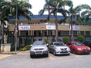
French School of Kuala Lumpur
Private, international school
Distance: Approx. 1539 meters
Latitude and longitude: 3.1789586,101.6538016
The French School of Kuala Lumpur (French: Lycée français de Kuala Lumpur Henri-Fauconnier, LFKL; Malay: Sekolah Perancis Kuala Lumpur) is a French international school in Segambut, Kuala Lumpur, Malaysia. Its education levels range from kindergarten through lycée (senior high school). The school first opened in 1962.
Saidina Umar Al Khattab Mosque
Mosque in Kuala Lumpur, Malaysia
Distance: Approx. 1732 meters
Latitude and longitude: 3.15,101.65511111
The Saidina Umar Al Khattab Mosque (MSUAK) (Malay: Masjid Saidina Umar Al Khattab) is a prominent mosque in Bukit Damansara (Damansara Heights), Kuala Lumpur, Malaysia. The mosque was officially opened on 22 March 1984 by the seventh Yang di-Pertuan Agong, Sultan Ahmad Shah of Pahang and was named after Muhammad's successor (Caliph) Umar Al Khattab.
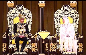
Installation of Yang di-Pertuan Agong XVI
Installation of Malaysia's sovereign
Distance: Approx. 1360 meters
Latitude and longitude: 3.16138889,101.66361111
The installation of Al-Sultan Abdullah Ri'ayatuddin Al-Mustafa Billah Shah ibni Almarhum Sultan Haji Ahmad Shah Al-Musta'in Billah as the sixteenth Yang di-Pertuan Agong of Malaysia took place in a Malay Royal Ceremony at the Balairong Seri, Istana Negara, Kuala Lumpur on Tuesday, 30 July 2019 at 10 a.m. He was elected earlier by the Malay Rulers in the 251st Special Meeting of Conference of Rulers which was held at Istana Negara on 24 January 2019. The meeting was held upon the abdication of the previous Yang di-Pertuan Agong, Sultan Muhammad V of Kelantan who abdicated from his post on 6 January 2019.

Installation of Yang di-Pertuan Agong XVII
Installation of Malaysia's sovereign
Distance: Approx. 1360 meters
Latitude and longitude: 3.16138889,101.66361111
The installation of Sultan Ibrahim as the 17th Yang di-Pertuan Agong took place on 20 July 2024, a few months after Ibrahim ascended the throne on 31 January 2024 at Balairung Seri, Istana Negara, Kuala Lumpur. During the ceremony, the new Agong recited his Oath of Installation and gave his first speech from the Throne. Ibrahim was elected by the Malay Rulers in the 263rd Special Meeting of the Conference of Rulers, held at Istana Negara on 27 October 2023.
Bukit Sri Bintang
Hill in Kuala Lumpur
Distance: Approx. 2021 meters
Latitude and longitude: 3.18055556,101.64222222
Bukit Sri Bintang is forested twin hill in Kepong, Kuala Lumpur, Malaysia. It is actually part of a more extensive forested area which extends south as far as Bukit Kiara and is separated from this area by the E1 New Klang Valley Expressway. The highest peak of the hill is 212 metres above sea level.
Weather in this IP's area
light rain
33 Celsius
39 Celsius
32 Celsius
33 Celsius
1008 hPa
61 %
1008 hPa
1000 hPa
10000 meters
2.19 m/s
2.73 m/s
243 degree
80 %
06:57:03
18:59:19