Country:
 Bangladesh
Region:
City:
Latitude and Longitude:
Time Zone:
Postal Code:
IP information under different IP Channel
ip-api
Country
Region
City
ASN
Time Zone
ISP
Blacklist
Proxy
Latitude
Longitude
Postal
Route
IPinfo
Country
Region
City
ASN
Time Zone
ISP
Blacklist
Proxy
Latitude
Longitude
Postal
Route
MaxMind
Country
Region
City
ASN
Time Zone
ISP
Blacklist
Proxy
Latitude
Longitude
Postal
Route
Luminati
Country
 SG
SGCity
singapore
ASN
Time Zone
Asia/Singapore
ISP
Host Universal Pty Ltd
Latitude
Longitude
Postal
db-ip
Country
Region
City
ASN
Time Zone
ISP
Blacklist
Proxy
Latitude
Longitude
Postal
Route
ipdata
Country
Region
City
ASN
Time Zone
ISP
Blacklist
Proxy
Latitude
Longitude
Postal
Route
Popular places and events near this IP address
Khilgaon Thana
Neighbourhood in Dhaka, Bangladesh
Distance: Approx. 881 meters
Latitude and longitude: 23.75083333,90.42638889
Khilgaon (Bengali: খিলগাঁও) is a thana (police jurisdiction) and neighbourhood in the city of Dhaka, Bangladesh. The thana encompasses Dhaka South City Corporation wards 24, 25, and 26. In 2022, it had a population of about 380 thousand.
Millennium University
Distance: Approx. 402 meters
Latitude and longitude: 23.7421,90.4185
The Millennium University (Bengali: মিলেনিয়াম বিশ্ববিদ্যালয়) or TMU is a non-governmental university located at Dhaka, Bangladesh. The university is sponsored by Khan Foundation, a Philanthropic Private Development Organisation (PVDO) and established under the Private University Act 1992. It is affiliated to the Government of Bangladesh and overseen by the University Grants Commission Bangladesh.

Motijheel Government Boys' High School
High school in Motijheel, Dhaka, Bangladesh
Distance: Approx. 724 meters
Latitude and longitude: 23.7389,90.4204
Motijheel Government Boys' High School And College (Bengali: মতিঝিল সরকারি বালক উচ্চ বিদ্যালয় এন্ড কলেজ) is located at Outer Circular Road, Motijheel, Dhaka, Bangladesh. It was established in 1957 as 'Motijheel Central Government High School'. The students of the school liked to call this school 'Centralian'.

Malibagh
Neighbourhood in Dhaka South City Corporation, Dhaka, Bangladesh
Distance: Approx. 628 meters
Latitude and longitude: 23.7473,90.4143
Malibagh or Malibag (Bengali: মালিবাগ, romanized: Mālibāg, lit. 'gardeners' garden') is a neighbourhood in Dhaka, Bangladesh. It holds the distinction of being one of the oldest and most traditional neighbourhoods in the city. Considered one of the most populated areas in Dhaka, the area falls under the precinct of Shahjahanpur Thana in Dhaka South City Corporation wards 12 and 19 and is encompassed by the Dhaka-8 constituency of Jatiya Sangsad.
Detective Training School
Police training school in Rajarbag, Dhaka, Bangladesh
Distance: Approx. 876 meters
Latitude and longitude: 23.7381,90.4169
Detective Training School (DTS) is maintained by Criminal Investigation Department (CID) of Bangladesh Police. It is situated on 0.727 acres (2,940 m2) of land at Rajarbag in Dhaka. It arranges various courses in the area of investigation and supervision.
Rajarbagh
Distance: Approx. 635 meters
Latitude and longitude: 23.74,90.4181
Rajarbagh is a residential area of Dhaka, Bangladesh. There is a police line in Rajarbagh. The areas adjacent to it are Shantinagar, Motijheel, Malibagh, Shantibagh, Momenbagh, Shahidbagh, Siddheshwari and Shahjahanpur.

Jamia Shariyyah Malibagh, Dhaka
Distance: Approx. 776 meters
Latitude and longitude: 23.7504,90.4148
Jamia Shariyah Malibagh (Bengali: জামিয়া শারইয়্যাহ মালিবাগ Arabic: الجامعة الشرعية ماليباغ), also known as Jamia Shariyah Madrasa, is one of the established Qawmi jamiahs in Dhaka, Bangladesh.

Bulbul Lalitakala Academy
Fine arts school in Dhaka, Bangladesh
Distance: Approx. 606 meters
Latitude and longitude: 23.7498,90.4236
Bulbul Lalitakala Academy (now known as Bulbul Academy of Fine Arts or BAFA) is an institution of fine arts established in Dhaka on 17 May 1955, founded by Begum Afroza Bulbul, wife of Bulbul Chowdhury, under the financial support of the government.
Park International School and College, Dhaka
Private school in Block#B,Khilgaon Taltola, Bangladesh
Distance: Approx. 802 meters
Latitude and longitude: 23.7526,90.4201
Park International School and College in Dhaka, Bangladesh started in the year of 2009. The school follows the English Medium British Curriculum from Cambridge University.
Ward No. 1 (Dhaka South City Corporation)
Dhaka South City Corporation in Dhaka Division, Bangladesh
Distance: Approx. 843 meters
Latitude and longitude: 23.75,90.42666667
Ward No. 1 Dhaka South City Corporation (Bengali: ওয়ার্ড নং ১, ঢাকা দক্ষিণ সিটি কর্পোরেশন) is an administrative division of Dhaka South City Corporation in zone 1, which formally known as ward no. 24 of Dhaka City Corporation.
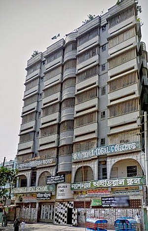
National Ideal College
Private school in Bangladesh
Distance: Approx. 753 meters
Latitude and longitude: 23.7503,90.4252
National Ideal College (NIC) (Bengali: ন্যাশনাল আইডিয়াল কলেজ) is a higher secondary institution in Khilgaon Thana, Dhaka, Bangladesh. It was founded by ideal foundation in 2001. National Ideal College provides education for Science, Commerce and Humanities division and for both boys and girls.
Bangladesh Police Liberation War Museum
War museum in Rajarbagh Police Lines
Distance: Approx. 691 meters
Latitude and longitude: 23.73925,90.41919444
Bangladesh Police Liberation War Museum is a museum that commemorates the contribution of Bangladesh Police to the Bangladesh Liberation War. It is located at Rajarbagh Police Lines on 1.5 bighas of (216,000 sq ft) land area and was established on 24 March 2013. It contains various materials and symbols which denote the sacrifice of police soldiers during the war.
Weather in this IP's area
haze
31 Celsius
38 Celsius
31 Celsius
31 Celsius
1005 hPa
74 %
1005 hPa
1003 hPa
5000 meters
3.6 m/s
110 degree
40 %
05:42:35
18:09:45