Country:
 Malaysia
Region:
City:
Latitude and Longitude:
Time Zone:
Postal Code:
IP information under different IP Channel
ip-api
Country
Region
City
ASN
Time Zone
ISP
Blacklist
Proxy
Latitude
Longitude
Postal
Route
IPinfo
Country
Region
City
ASN
Time Zone
ISP
Blacklist
Proxy
Latitude
Longitude
Postal
Route
MaxMind
Country
Region
City
ASN
Time Zone
ISP
Blacklist
Proxy
Latitude
Longitude
Postal
Route
Luminati
Country
MYRegion
14
City
kualalumpur
ASN
Time Zone
Asia/Kuala_Lumpur
ISP
Starry Network Limited
Latitude
Longitude
Postal
db-ip
Country
Region
City
ASN
Time Zone
ISP
Blacklist
Proxy
Latitude
Longitude
Postal
Route
ipdata
Country
Region
City
ASN
Time Zone
ISP
Blacklist
Proxy
Latitude
Longitude
Postal
Route
Popular places and events near this IP address

Ipoh
City and state capital in Perak, Malaysia
Distance: Approx. 2457 meters
Latitude and longitude: 4.59722222,101.075
Ipoh (, Malay pronunciation: [i.poh]) is the capital city of the Malaysian state of Perak. Located by the Kinta River, it is nearly 200 km (120 mi) north of Kuala Lumpur and 150 km (93 mi) southeast of George Town in neighbouring Penang. As of the 2020 census Ipoh had a population of 759,952, making it the eighth-largest city in Malaysia by population.

Sultan Idris Shah II Mosque
Mosque in Kinta, Perak, Malaysia
Distance: Approx. 2586 meters
Latitude and longitude: 4.59616667,101.07583333
The Sultan Idris Shah II Mosque (Malay: Masjid Sultan Idris Shah II) is the state mosque of Perak, Malaysia. It is situated in Ipoh, Perak's capital city, near the Birch Memorial Clock Tower.

Paloh Street Mosque, Ipoh
Mosque in Kinta, Perak, Malaysia
Distance: Approx. 3025 meters
Latitude and longitude: 4.58994444,101.07702778
Kg. Paloh Mosque is one of the oldest mosques in Ipoh, Perak, Malaysia. Located at Jalan Datoh, it was built in 1912 by Wan Muhammad Saleh, superintendent of Penghulus and assistant collector of Land Revenue during the Frank Swettenham administration.
Ipoh railway station
Railway station in Kinta, Perak, Malaysia
Distance: Approx. 2284 meters
Latitude and longitude: 4.59722222,101.07333333
The Ipoh railway station is a Malaysian train station located on the southwestern side of and named after the capital city of Ipoh, Perak. It serves as the main railway terminal for the state under Keretapi Tanah Melayu offering KTM ETS services, as well as handling freight trains. Although there are nine tracks, only four are electrified and three of the electrified tracks are used for the ETS service.
Sungei Pari Towers
Public housing project in Ipoh, Malaysia
Distance: Approx. 2012 meters
Latitude and longitude: 4.59383,101.06861
Sungei Pari Towers, alternately Sungai Pari Towers (Chinese: 雙溪巴裏組屋, colloquially 十五樓 - literally 15 storeys) is a dilapidated public housing project in Ipoh, Perak, Malaysia which was built in 1963. It is located in the Buntong ward in the western part of Ipoh, along Jalan Gurdwara by the Pari River and west of Ipoh Railway Station.
Church of Our Lady of Lourdes, Ipoh
Distance: Approx. 1619 meters
Latitude and longitude: 4.60313889,101.06869444
The Church of Our Lady of Lourdes was officially established by Father Emile Marie Henri Sausseau (MEP) in 1905 at Ipoh, Malaysia.

Han Chin Pet Soo
Hakka tin mining museum in Ipoh, Malaysia
Distance: Approx. 2905 meters
Latitude and longitude: 4.59611111,101.07888889
Han Chin Pet Soo (闲真别墅) is Malaysia's first Hakka tin mining museum and is the number one attraction in Ipoh on TripAdvisor. Located on the edge of Ipoh's Old Town, close to the Kinta River, it is in walking distance of the well-known Panglima Lane (Concubine Lane). It is managed by Ipoh World Sdn.
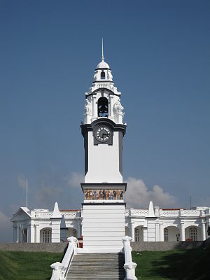
Birch Memorial Clock Tower
Clock tower in Kinta, Perak, Malaysia
Distance: Approx. 2588 meters
Latitude and longitude: 4.59683333,101.07611111
The Birch Memorial Clock Tower (Malay: Menara Jam Peringatan Birch) is a clock tower in Ipoh, Kinta District, Perak, Malaysia.
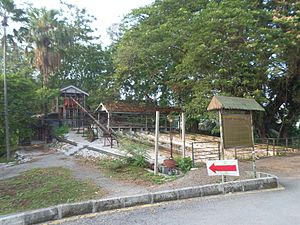
Palong Tin Museum
Museum in Kinta, Perak, Malaysia
Distance: Approx. 2974 meters
Latitude and longitude: 4.60308333,101.08094444
The Palong Tin Museum is a museum in Ipoh, Kinta District, Perak, Malaysia.
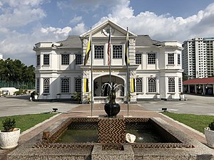
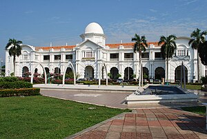
Darul Ridzuan Museum
Museum in Kinta, Perak, Malaysia
Distance: Approx. 2641 meters
Latitude and longitude: 4.60452778,101.078
The Darul Ridzuan Museum (Malay: Muzium Darul Ridzuan) is a museum in Ipoh, Kinta District, Perak, Malaysia.
Falim
Suburb of Ipoh, Perak, Malaysia
Distance: Approx. 2632 meters
Latitude and longitude: 4.581698,101.0592632
Falim (Jawi: فاليم) is a suburb of Ipoh, Perak, Malaysia.
Buntong
Suburb of Ipoh, Perak, Malaysia
Distance: Approx. 1991 meters
Latitude and longitude: 4.59425,101.06869444
Buntong (Jawi: بونتوڠ; Chinese: 文冬, Tamil: புந்தோங்) is a suburb of Ipoh, Perak, Malaysia. Buntong is one of the largest residential areas in the city of Ipoh. Buntong is popular for Kampung Kacang Puteh, a major industrial hub for producing famous Indian bites like sweets and murukku.
Weather in this IP's area
few clouds
25 Celsius
26 Celsius
25 Celsius
26 Celsius
1009 hPa
88 %
1009 hPa
1003 hPa
9000 meters
2.24 m/s
20 degree
20 %
07:05:50
19:13:25