103.57.255.104 - IP Lookup: Free IP Address Lookup, Postal Code Lookup, IP Location Lookup, IP ASN, Public IP
Country:
Region:
City:
Location:
Time Zone:
Postal Code:
ISP:
ASN:
language:
User-Agent:
Proxy IP:
Blacklist:
IP information under different IP Channel
ip-api
Country
Region
City
ASN
Time Zone
ISP
Blacklist
Proxy
Latitude
Longitude
Postal
Route
db-ip
Country
Region
City
ASN
Time Zone
ISP
Blacklist
Proxy
Latitude
Longitude
Postal
Route
IPinfo
Country
Region
City
ASN
Time Zone
ISP
Blacklist
Proxy
Latitude
Longitude
Postal
Route
IP2Location
103.57.255.104Country
Region
maharashtra
City
aurangabad
Time Zone
Asia/Kolkata
ISP
Language
User-Agent
Latitude
Longitude
Postal
ipdata
Country
Region
City
ASN
Time Zone
ISP
Blacklist
Proxy
Latitude
Longitude
Postal
Route
Popular places and events near this IP address

Marathwada
Segmented region of the Kingdom of Hyderabad
Distance: Approx. 0 meters
Latitude and longitude: 19.8833,75.3333
Marathwada (Marathi pronunciation: [məɾaːʈʰʋaːɖa]) is a proposed state and geographical region of the Indian state of Maharashtra. It was formed during the Nizam's rule and was part of the then Hyderabad State. The region coincides with the Aurangabad division of Maharashtra.
Aurangabad district, Maharashtra
District of Maharashtra in India
Distance: Approx. 1224 meters
Latitude and longitude: 19.88878611,75.34343611
Aurangabad district (Marathi pronunciation: [əu̯ɾəŋɡaːbaːd̪]), officially known as Chhatrapati Sambhajinagar district, is one of the 36 districts of the state of Maharashtra in western India. It borders the districts of Nashik to the west, Jalgaon to the north, Jalna to the east, and Ahmednagar to the south. The city of Aurangabad houses the district's administrative headquarters.

Aurangabad division
Place in Maharashtra, India
Distance: Approx. 1224 meters
Latitude and longitude: 19.88878611,75.34343611
Aurangabad division, officially known as Chhatrapati Sambhajinagar division is one of the six administrative divisions of Maharashtra state in India. It represents the Marathwada region of Maharashtra and is synonymous with it.

Aurangabad, Maharashtra Lok Sabha constituency
Lok Sabha Constituency in Maharashtra
Distance: Approx. 1224 meters
Latitude and longitude: 19.88878611,75.34343611
Aurangabad Lok Sabha constituency is one of the 48 Lok Sabha (parliamentary) constituencies in Maharashtra state in western India.
Bhadkal Gate
1612 memorial in Maharashtra, India
Distance: Approx. 1359 meters
Latitude and longitude: 19.888733,75.321676
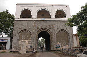
Bhadkal Gate is a structure in Aurangabad City in Maharashtra, India. This gate is the biggest in the city. It was built by Ahamadnagar's Murtaza Nizamshah's vizier Malik Ambar to commemorate the victory against the Mughals in 1612.
Gates in Aurangabad
Distance: Approx. 1224 meters
Latitude and longitude: 19.88878611,75.34343611
The Gates of Aurangabad distinguish it from several other medieval cities in India. Each of the 52 gates have a local history or had individuals linked with it. Out of the 52, only four main and nine subordinate gates have survived, the most famous, oldest and biggest of them being the Bhadkal Gate near the Naukhanda Palace of Nizams.

Neighborhoods of Aurangabad
Distance: Approx. 650 meters
Latitude and longitude: 19.88830278,75.33009722
When Aurangzeb made Aurangabad his capital, there were 54 suburbs which were walled in like the city itself, but the chief of these that were populated in the 19th century were Begampura and Aurang-pura.
Sikandar Ali Wajd
Distance: Approx. 1245 meters
Latitude and longitude: 19.8892,75.3232
Sikandar Ali Wajd (1914–1983) was a talented Urdu poet from Aurangabad, Maharashtra India. He had equal proficiency in composing gazals and poems.
Jama Mosque, Aurangabad
Mosque in Aurangabad, Maharashtra, India
Distance: Approx. 1215 meters
Latitude and longitude: 19.89178491,75.32600564
The Jama Masjid is a mosque built in 1612 AD, located near the Killa Arrak in Aurangabad, Maharashtra, India. It is historically significant because it was constructed in 1612 AD, very soon after the foundation of Aurangabad (then called "Fatehpur") by Malik Amber in 1610 AD. The mosque was later extended by Aurangzeb(R.H) in the year 1692 AD, it is one of the oldest mosques of Aurangabad which is still in good condition.

Kendriya Vidyalaya Aurangabad
School in Maharashtra, India
Distance: Approx. 0 meters
Latitude and longitude: 19.8833,75.3333
Kendriya Vidyalaya, Aurangabad is a school in Aurangabad, Maharashtra, India. This school is a part of Kendriya Vidyalaya Sangathan. It is a central government school which is under the Ministry of Human Resource Development, Government of India.

Qila-e-Ark
Palace fort in Aurangabad, Maharashtra
Distance: Approx. 1224 meters
Latitude and longitude: 19.88878611,75.34343611
Qila-e-Ark is a 17th-century palace/citadel complex in Aurangabad, Maharashtra. Built by Mughal emperor Aurangzeb when he was a prince, it served as his royal residence during his subsequent reign as emperor. The site is currently ruined, and has no legal protected status; several modern-day buildings also encroach the complex.

Alamgir Mosque, Aurangabad
17th-century Mughal mosque in Maharashtra, India
Distance: Approx. 1394 meters
Latitude and longitude: 19.89581446,75.3327911
The Shahi Mosque, also known as the Alamgiri Mosque, is located in Aurangabad, a city in Maharashtra, India. It was built in 1693 by Mughal emperor Aurangzeb for his private use. It is one of the few surviving structures of the Qila-e-Ark, a fortified palace complex built as Aurangzeb's residence in Aurangabad, and is situated in its eastern flank.
Weather in this IP's area
clear sky
28 Celsius
27 Celsius
28 Celsius
28 Celsius
1011 hPa
29 %
1011 hPa
942 hPa
10000 meters
3.3 m/s
3.14 m/s
97 degree
2 %

