103.57.207.226 - IP Lookup: Free IP Address Lookup, Postal Code Lookup, IP Location Lookup, IP ASN, Public IP
Country:
Region:
City:
Location:
Time Zone:
Postal Code:
IP information under different IP Channel
ip-api
Country
Region
City
ASN
Time Zone
ISP
Blacklist
Proxy
Latitude
Longitude
Postal
Route
Luminati
Country
Region
04
City
mandalay
ASN
Time Zone
Asia/Yangon
ISP
Myanmar Country Co., Ltd.
Latitude
Longitude
Postal
IPinfo
Country
Region
City
ASN
Time Zone
ISP
Blacklist
Proxy
Latitude
Longitude
Postal
Route
IP2Location
103.57.207.226Country
Region
mandalay
City
mandalay
Time Zone
Asia/Rangoon
ISP
Language
User-Agent
Latitude
Longitude
Postal
db-ip
Country
Region
City
ASN
Time Zone
ISP
Blacklist
Proxy
Latitude
Longitude
Postal
Route
ipdata
Country
Region
City
ASN
Time Zone
ISP
Blacklist
Proxy
Latitude
Longitude
Postal
Route
Popular places and events near this IP address

Mandalay
Second-largest city in Myanmar
Distance: Approx. 934 meters
Latitude and longitude: 21.98305556,96.08444444
Mandalay ( or ; Burmese: မန္တလေး; MLCTS: manta.le: [màndəlé]) is the second-largest city in Myanmar, after Yangon. Located on the east bank of the Irrawaddy River, 631 km (392 miles; road distance) north of Yangon, the city has a population of 1,225,553 (2014 census). Mandalay was founded in 1857 by King Mindon, replacing Amarapura as the new royal capital of the Konbaung dynasty.

Chanayethazan Township
Township of Mandalay in Myanmar
Distance: Approx. 895 meters
Latitude and longitude: 21.96666667,96.08333333
Chanayethazan Township (Burmese: ချမ်းအေးသာစံ မြို့နယ်, pronounced [tɕʰáɰ̃ ʔé θà zàɰ̃ mjo̰nɛ̀]) is a township located in downtown Mandalay, Myanmar. The township is bounded by Aungmyethazan Township and the Mandalay Palace in the north, and Patheingyi Township in the east, Maha Aungmye Township in the south, and the Ayeyarwady river in the west. Chanayethazan is the main business district of the city.

Mandalay District
Former district of Mandalay Region in Myanmar
Distance: Approx. 895 meters
Latitude and longitude: 21.96666667,96.08333333
Mandalay District (Burmese: မန္တလေး ခရိုင်) was a district of the Mandalay Region in central Myanmar. Though the district used to consist of two cities, Mandalay and Amarapura, today, with the urban sprawl of Mandalay capturing Amarapura and Patheingyi, the district and the city of Mandalay are one and the same. The district was dissolved and formed as Aungmyethazan District, Maha Aungmye District and Amarapura District on 30 April 2022.
Mandalay Central railway station
Principal railway station serving Mandalay, Myanmar
Distance: Approx. 360 meters
Latitude and longitude: 21.97694444,96.08611111
Mandalay Central railway station (Burmese: မန္တလေး ဘူတာကြီး), located in downtown Mandalay, is one of the largest rail stations in Myanmar. The station is Upper Myanmar's gateway to the 3,126-mile (5,031 km) national rail network. It is the terminus of the main rail line from Yangon and the starting point of branch lines to Pyin U Lwin (Maymyo), Lashio, Monywa, Pakokku, Kalay, Gangaw, and to the north, Shwebo, Kawlin, Naba, Kanbalu, Mohnyin, Hopin, Mogaung and Myitkyina.

Naypyidaw Union Territory
Union territory of Myanmar
Distance: Approx. 895 meters
Latitude and longitude: 21.96666667,96.08333333
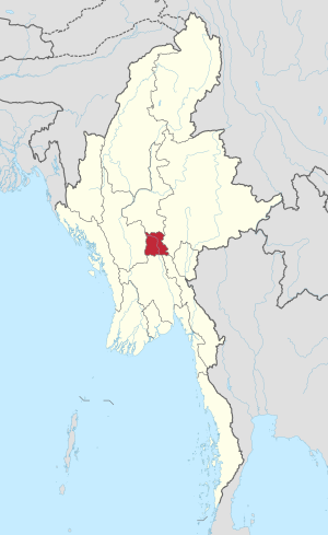
The Union Territory (Nay Pyi Taw) (Burmese: ပြည်ထောင်စုနယ်မြေ (နေပြည်တော်)), also called Nay Pyi Taw Council Territory (နေပြည်တော်ကောင်စီနယ်မြေ) (Nay Pyi Taw also spelled Nay Pyitaw, Naypyidaw or Nay Pyi Daw) is an administrative division in central Myanmar (Burma). It contains Naypyidaw, the capital city of Myanmar.

Mandalay General Hospital
Hospital in Mandalay Region, Myanmar
Distance: Approx. 783 meters
Latitude and longitude: 21.9775,96.09055556
Mandalay General Hospital (Burmese: မန္တလေးပြည်သူ့ဆေးရုံကြီး; abbreviated MGH) is a major teaching hospital in Mandalay, Myanmar, with a bed capacity of 1,500. It serves as the primary teaching institution for University of Medicine, Mandalay, alongside Mandalay Workers' Hospital. It is located on 30th Street, between 74th and 77th Streets in Chanayethazan Township.

Yadanabon Market
Market in Mandalay, Myanmar
Distance: Approx. 538 meters
Latitude and longitude: 21.971422,96.087434
Yadanabon Market (Burmese: ရတနာပုံဈေး) is Mandalay's second-largest market. It is between 77th and 33rd and 34th streets, near the Mandalay Central Railway Station. The market is now beside the Diamond Plaza.
Setkyathiha Pagoda
Buddhist Pagoda in Mandalay, Myanmar
Distance: Approx. 918 meters
Latitude and longitude: 21.9768,96.075
Setkyathiha Pagoda (Burmese: စကြာသီဟစေတီ) is a notable pagoda in Mandalay, Burma. It is known for a large bronze image of the Buddha cast by King Bagyidaw in Inwa just before the beginning of the First Anglo-Burmese War in 1824. The image was subsequently moved to Amarapura in 1852 when the Second Anglo-Burmese War broke out, and to Mandalay in 1885 when the Third Anglo-Burmese War broke out.

Sacred Heart Cathedral, Mandalay
Church in Mandalay, Myanmar
Distance: Approx. 1086 meters
Latitude and longitude: 21.983826,96.0798818
The Sacred Heart Cathedral (Burmese: ရွှေနှလုံးတော် ကက်သလစ် ဘုရားရှိခိုးကျောင်း) is a Roman Catholic cathedral in Mandalay, Myanmar. Consecrated in 1890, the cathedral is located on 81st Road between 25th and 26th streets. It serves as the headquarters of the Metropolitan Archdiocese of Mandalay (Archidioecesis Mandalayensis), follows the Roman or Latin rite and is decorated with blue and white colors.

Diamond Plaza (Mandalay)
Shopping Centre in bet. and streets, Chanaye Thazan
Distance: Approx. 374 meters
Latitude and longitude: 21.9715883,96.0849588
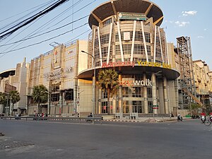
Diamond Plaza (Burmese: ဒိုင်းမွန်း ပလာဇာ) is one of the biggest shopping centres, located in downtown Mandalay near the Mandalay Central Railway Station. The complex consists of two towers: Tower A (Diamond Plaza) and Tower B (Yadanabon Super Centre).

Man Myanmar Plaza
Distance: Approx. 975 meters
Latitude and longitude: 21.9813723,96.0774863
Man Myanmar Plaza (Burmese: မန်း မြန်မာ ပလာဇာ; also known as Man Myanmar Zegyo Plaza (မန်း မြန်မာ ဈေးချို ပလာဇာ)) is a mixed use complex in Mandalay, Myanmar. The complex consists of a 13,935 m2 (150,000 sq ft) six-story shopping center, and two 25-story condominium buildings. From 2014 until the completion of Grand Park Hotel, Mandalay in 2019, the twin condo towers were the tallest buildings in Mandalay, as well as the tallest buildings outside of Yangon.
Ludu Library
Archive library in Mandalay, Myanmar
Distance: Approx. 571 meters
Latitude and longitude: 21.97390857,96.07813807
The Ludu Library and Archive (Burmese: လူထုစာကြည့်တိုက်နှင့်မော်ကွန်းတိုက်) is a public library and newspaper archive in Letsekan quarter, Chanayethazan Township, Mandalay, Myanmar. Construction began in 2000, and the library was formally founded in 2004 by the family of Ludu U Hla and his wife Daw Amar, prominent Burmese writers. The library was an extension of a private collection curated by the Ludu family and survived the 1984 Kya Gyi fire in Mandalay.
Weather in this IP's area
clear sky
29 Celsius
28 Celsius
29 Celsius
29 Celsius
1010 hPa
36 %
1010 hPa
996 hPa
10000 meters
1.99 m/s
1.67 m/s
283 degree
1 %
