Country:
 New Zealand
Region:
City:
Latitude and Longitude:
Time Zone:
Postal Code:
IP information under different IP Channel
ip-api
Country
Region
City
ASN
Time Zone
ISP
Blacklist
Proxy
Latitude
Longitude
Postal
Route
IPinfo
Country
Region
City
ASN
Time Zone
ISP
Blacklist
Proxy
Latitude
Longitude
Postal
Route
MaxMind
Country
Region
City
ASN
Time Zone
ISP
Blacklist
Proxy
Latitude
Longitude
Postal
Route
Luminati
Country
NZASN
Time Zone
Pacific/Auckland
ISP
Hoopla Hosting Limited
Latitude
Longitude
Postal
db-ip
Country
Region
City
ASN
Time Zone
ISP
Blacklist
Proxy
Latitude
Longitude
Postal
Route
ipdata
Country
Region
City
ASN
Time Zone
ISP
Blacklist
Proxy
Latitude
Longitude
Postal
Route
Popular places and events near this IP address

Christchurch
City in Canterbury, New Zealand
Distance: Approx. 110 meters
Latitude and longitude: -43.53111111,172.63611111
Christchurch ( ; Māori: Ōtautahi) is the largest city in the South Island and the second-largest city by urban area population in New Zealand. Christchurch has a population of 396,200 and is located in the Canterbury Region, near the centre of the east coast of the South Island, east of the Canterbury Plains. It is located near the southern end of Pegasus Bay, and is bounded to the east by the Pacific Ocean and to the south by the ancient volcanic complex of the Banks Peninsula.

Cathedral Square, Christchurch
Square in Christchurch, New Zealand
Distance: Approx. 144 meters
Latitude and longitude: -43.53083333,172.63638889
Cathedral Square, locally known simply as the Square, is the geographical centre and heart of Christchurch, New Zealand, where the city's Anglican cathedral, ChristChurch Cathedral is located. The square stands at the theoretical crossing of the city's two main orthogonal streets, Colombo Street and Worcester Street, though in practice both have been either blocked off or detoured around the square itself. The square was badly damaged in the February 2011 Christchurch earthquake.

Christ Church Cathedral, Christchurch
Church in Christchurch Central City, New Zealand
Distance: Approx. 147 meters
Latitude and longitude: -43.531,172.637
ChristChurch Cathedral, also called Christ Church Cathedral and (rarely) Cathedral Church of Christ, is a deconsecrated Anglican cathedral in the city of Christchurch, New Zealand. It was built between 1864 and 1904 in the centre of the city, surrounded by Cathedral Square. It became the cathedral seat of the Bishop of Christchurch, who is in the New Zealand tikanga of the Anglican Church in Aotearoa, New Zealand and Polynesia.
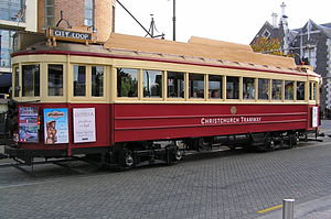
Christchurch tramway system
Tram transport network of Christchurch, New Zealand
Distance: Approx. 182 meters
Latitude and longitude: -43.53091667,172.63444444
The Christchurch tramway system was an extensive network in Christchurch, New Zealand, with steam and horse trams from 1882. Electric trams ran from 1905 to 1954, when the last line from Cashmere to Papanui was replaced by buses. In 1995, a 2.5-kilometre (1.6 mi) central city loop heritage tram was reopened in the central city as a tourist attraction.

Ballantynes fire
1947 fire in Christchurch, New Zealand
Distance: Approx. 147 meters
Latitude and longitude: -43.533414,172.63622
On Tuesday, 18 November 1947, a fire engulfed the Ballantynes department store in central Christchurch, New Zealand, resulting in the death of 41 people. It remains the deadliest fire in New Zealand's history.

Christchurch Central City
Central area of Christchurch, New Zealand
Distance: Approx. 129 meters
Latitude and longitude: -43.531,172.6365
Christchurch Central City or Christchurch City Centre is the geographical centre and the heart of Christchurch, New Zealand. It is defined as the area within the Four Avenues (Bealey Avenue, Fitzgerald Avenue, Moorhouse Avenue and Deans Avenue) and thus includes the densely built up central city, some less dense surrounding areas of residential, educational and industrial usage, and green space including Hagley Park, the Christchurch Botanic Gardens and the Barbadoes Street Cemetery. It suffered heavy damage in the 2010 Canterbury earthquake and was devastated in the 2011 Christchurch earthquake.

Statue of John Robert Godley
Statue in Cathedral Square, Christchurch, New Zealand
Distance: Approx. 127 meters
Latitude and longitude: -43.53096,172.63599
The Godley Statue is a bronze statue situated in Cathedral Square in Christchurch, New Zealand. It commemorates the "Founder of Canterbury" John Robert Godley. It was the first statue portraying a person in New Zealand.

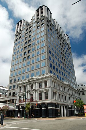
Chief Post Office, Christchurch
Government, with some commercial enterprises in Christchurch, New Zealand
Distance: Approx. 58 meters
Latitude and longitude: -43.5316,172.6358
The Chief Post Office or Christchurch Central Post Office, originally known as the Government Buildings, is located in Cathedral Square, Christchurch, New Zealand. The building was initially a post office with Immigration, Customs and Public Works departments. The Government Buildings were later replaced by the new Government Buildings opened in 1913, and the Chief Post Office remained on-site.
Clarendon Tower
Former building in Christchurch, New Zealand
Distance: Approx. 168 meters
Latitude and longitude: -43.53138889,172.63416667
Clarendon Tower was a high rise building on Worcester Street at Oxford Terrace in the Christchurch Central City, New Zealand. Built on the site of the former Clarendon Hotel, the façade of the historic building was kept in the redevelopment and was protected by the New Zealand Historic Places Trust as a Category II heritage structure. Following damage from the February 2011 Christchurch earthquake, the 17-storey building has been demolished.

City Mall, Christchurch
Street in Christchurch Central City, New Zealand
Distance: Approx. 126 meters
Latitude and longitude: -43.53257778,172.63741389
City Mall is the main pedestrian mall in the central city of Christchurch, New Zealand, comprising two sections of Cashel Street plus the Bridge of Remembrance and one section of High Street. It is also known colloquially as Cashel Mall. The Bridge of Remembrance was pedestrianised in 1976.
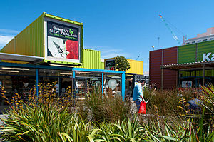
Re:START
Temporary mall in Christchurch, New Zealand
Distance: Approx. 150 meters
Latitude and longitude: -43.53326944,172.635075
Container Mall (originally called Re:START) was a temporary mall built from shipping containers in Christchurch Central City, New Zealand. It was a response to the 22 February 2011 Christchurch earthquake, which destroyed most buildings in City Mall (Cashel and High Streets), and resulted in the central city being cordoned off from public access while buildings were being demolished. Initially considered a short-term response to the lack of permanent buildings, Re:START was popular with locals and tourists alike and remained open for business until January 2018.

Hallensteins Building
Building in Christchurch Central City, New Zealand
Distance: Approx. 163 meters
Latitude and longitude: -43.533,172.6376
The Hallensteins Building was a contemporary tower in central Christchurch, located on the High Street end of City Mall. It was sometimes referred to as the Unlimited Northern Tower due to its use as the main Unlimited Paenga Tawhiti campus building. The tower had five floors with a modern exterior, large glass windows, balconies, and a mezzanine floor on the top floor.
Weather in this IP's area
overcast clouds
11 Celsius
10 Celsius
10 Celsius
11 Celsius
1025 hPa
84 %
1025 hPa
1023 hPa
10000 meters
4.12 m/s
70 degree
100 %
06:32:47
19:56:09