Country:
 Pakistan
Region:
City:
Latitude and Longitude:
Time Zone:
Postal Code:
IP information under different IP Channel
ip-api
Country
Region
City
ASN
Time Zone
ISP
Blacklist
Proxy
Latitude
Longitude
Postal
Route
IPinfo
Country
Region
City
ASN
Time Zone
ISP
Blacklist
Proxy
Latitude
Longitude
Postal
Route
MaxMind
Country
Region
City
ASN
Time Zone
ISP
Blacklist
Proxy
Latitude
Longitude
Postal
Route
Luminati
Country
PKRegion
sd
City
sukkur
ASN
Time Zone
Asia/Karachi
ISP
Ebone Network PVT. Limited
Latitude
Longitude
Postal
db-ip
Country
Region
City
ASN
Time Zone
ISP
Blacklist
Proxy
Latitude
Longitude
Postal
Route
ipdata
Country
Region
City
ASN
Time Zone
ISP
Blacklist
Proxy
Latitude
Longitude
Postal
Route
Popular places and events near this IP address
Sukkur
Metropolis in Sindh, Pakistan
Distance: Approx. 422 meters
Latitude and longitude: 27.70611111,68.84833333
Sukkur (Sindhi: سکر; Urdu: سكھر) is a city in the Pakistani province of Sindh along the western bank of the Indus River, directly across from the historic city of Rohri. Sukkur is the third largest city in Sindh after Karachi and Hyderabad, and 14th largest city of Pakistan by population. The city was originally founded by the Rai dynasty of Sindh.
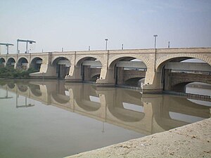
Sukkur Barrage
Barrage on the Indus in Sindh province, Pakistan
Distance: Approx. 3029 meters
Latitude and longitude: 27.68055556,68.84527778
Sukkur Barrage (Sindhi: سکر بئراج, Urdu: سکھر بیراج) is a barrage on the River Indus near the city of Sukkur in the Sindh province of Pakistan. The barrage was built during the British Raj from 1923 to 1932 and was named Lloyd Barrage. The Sukkur Barrage, is the pride of Pakistan's irrigation system as it is the largest single irrigation network of its kind in the world.

Sadh Belo
Hindu temple in Sindh, Pakistan
Distance: Approx. 2977 meters
Latitude and longitude: 27.69377778,68.87875
Sadh Belo (Sindhi: ساڌ ٻيلو), also spelt as Sadh Bela, or Sat, is an island in the Indus River near Sukkur, Sindh, Pakistan that is famous for its highly revered Udasi Sikhs temples. The temples are associated with the syncretic Udasi movement of Sikhism. The island is famous for Teerath Asthan which is the biggest Hindu temple in Pakistan.

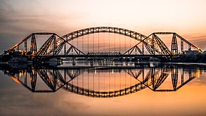
Lansdowne Bridge (Pakistan)
Indus-Bridge in Sukker, Pakistan
Distance: Approx. 3833 meters
Latitude and longitude: 27.69361111,68.88833333
The Lansdowne Bridge (Sindhi لينسڊائون پل; Urdu: لینس ڈاؤن پل) over the Indus at Sukkur was one of the great engineering feats of the 19th century. The longest cantilever bridge ever built, it had to support the load of heavy steam locomotives. The bridge was inaugurated on 25 March 1889.
Bukkur
Historical Island in Sindh, Pakistan
Distance: Approx. 3688 meters
Latitude and longitude: 27.69527778,68.8875
Bukkur, Bakhar or Bhakkar is a historical city and an Island fort situated between Rohri and Sukkur in the Sindh province of Pakistan. Bhakkar is also known as "Old Sukkur".
Lab-e-Mehran
Garden in Sukkur, Pakistan
Distance: Approx. 2258 meters
Latitude and longitude: 27.68673,68.85162
Lab-e-Mehran was an entertainment park in Sukkur, Pakistan. It is situated on the right bank of Indus River, adjacent to the Sukkur Barrage. It was built at a cost of 120 million rupees.
Ayub Bridge
Pakistani construction over the Indus river
Distance: Approx. 3815 meters
Latitude and longitude: 27.693788,68.888217
Ayub Bridge (Sindhi: ايوب پل; Urdu: ایوب پل ), named after Field Marshal Mohammad Ayub Khan (President of Pakistan), is a railway bridge over the Indus River between Rohri and Sukkur in Sindh province, Pakistan. The bridge is about 806 feet long, 247 feet high and cost Rs21.6 million. It has served the city for 50 years by providing a strong link for rail traffic between Sukkur and Rohri.

St. Mary's High School, Sukkur
School in Sukkur, Sindh, Pakistan
Distance: Approx. 2007 meters
Latitude and longitude: 27.69758333,68.86986111
St. Mary's High School is a private Catholic co-educational primary and secondary boarding and day school, located in Sukkur, Sindh, Pakistan. Founded in 1881, the school is administered by the Roman Catholic Diocese of Hyderabad in Pakistan.

Ghulam Muhammad Mahar Medical College
College in Sukkur, Sindh, Pakistan
Distance: Approx. 2168 meters
Latitude and longitude: 27.70508333,68.83061111
Ghulam Muhammad Mahar Medical College (غلام محمد مہر میڈیکل کالج) or GMMMC in short is the sixth public sector Medical college under the Government of Sindh where 100 students of Sukkur, Khairpur and Ghotki are getting education every year. It is named after Sindh politician Ghulam Muhammad Khan Mahar. It is a constituent College of Shaheed Mohtarma Benazir Bhutto Medical University, located in the center of Sukkur city GMMMC is home to 500 students in the MBBS programs, with clinical rotations occurring at GMMMC Teaching Hospital, Government Anwar Piracha Teaching Hospital, SIUT Chablani Medical Center Sukkur, National Institute of Cardiovascular Diseases (NICVD), Sukkur satellite center.
Clock Tower, Sukkur
Clock tower in Sukkur, Pakistan
Distance: Approx. 1806 meters
Latitude and longitude: 27.694498,68.864173
Clock Tower, Sukkur, also known as Ghanta Ghar, Sukkur, (Urdu: گھنٹہ گھر، سکھر) is a clock tower located in Sukkur, Sindh. The tower is 90-feet high.
Child Healthcare Institute Sukkur
Hospital in Sukkur Bypass
Distance: Approx. 2027 meters
Latitude and longitude: 27.70380556,68.83225
The Government of Sindh established the Child Healthcare Institute, the 200 beded state of the art children hospital at Sukkur, with the help of the South Korean government. The hospital was built over 27 acres of land adjacent to Ghulam Muhammad Mahar Medical College with a cost of US $57.274 million, at Airport Road, Sukkur. After completion the hospital was handed over to Sindh Institute of Child Health and Neonatology (SICHN).
Lloyd Barrage Museum
Museum in Sindh, Pakistan
Distance: Approx. 3789 meters
Latitude and longitude: 27.6733,68.8471
The Lloyd Barrage Museum (Urdu: لائیڈ بیراج میوزیم) is a museum situated on Lloyd Barrage in Sukkur, Sindh. It provides information related to the construction of the Lloyd Barrage.
Weather in this IP's area
clear sky
35 Celsius
34 Celsius
35 Celsius
35 Celsius
1011 hPa
20 %
1011 hPa
1004 hPa
10000 meters
1.62 m/s
1.68 m/s
152 degree
1 %
06:26:56
17:51:48