103.50.128.47 - IP Lookup: Free IP Address Lookup, Postal Code Lookup, IP Location Lookup, IP ASN, Public IP
Country:
Region:
City:
Location:
Time Zone:
Postal Code:
ISP:
ASN:
language:
User-Agent:
Proxy IP:
Blacklist:
IP information under different IP Channel
ip-api
Country
Region
City
ASN
Time Zone
ISP
Blacklist
Proxy
Latitude
Longitude
Postal
Route
db-ip
Country
Region
City
ASN
Time Zone
ISP
Blacklist
Proxy
Latitude
Longitude
Postal
Route
IPinfo
Country
Region
City
ASN
Time Zone
ISP
Blacklist
Proxy
Latitude
Longitude
Postal
Route
IP2Location
103.50.128.47Country
Region
jawa timur
City
prapen
Time Zone
Asia/Jakarta
ISP
Language
User-Agent
Latitude
Longitude
Postal
ipdata
Country
Region
City
ASN
Time Zone
ISP
Blacklist
Proxy
Latitude
Longitude
Postal
Route
Popular places and events near this IP address
University of Surabaya
Distance: Approx. 1391 meters
Latitude and longitude: -7.3198009,112.7681119
University of Surabaya (UBAYA) is a university in Rungkut, Surabaya, East Java, Indonesia. UBAYA is the successor to Trisakti University of Surabaya which was founded in 1966. Its name was changed to the University of Surabaya in 1968.
Petra Christian University
Private university located in Surabaya, Indonesia
Distance: Approx. 3494 meters
Latitude and longitude: -7.33947222,112.73752778
Petra Christian University, commonly abbreviated as PCU (Indonesian: Universitas Kristen Petra) is a major private Christian university the oldest and largest in Indonesia, located in Wonocolo District in Surabaya, East Java - Indonesia. It was established in 1961, founded by PPPK Petra, an educational Christian based in Surabaya which established in 1951. The Petra name itself is taken from the Greek language that translates as coral reef or rock.
Surabaya Zoo
Zoo in Surabaya, Indonesia
Distance: Approx. 3080 meters
Latitude and longitude: -7.29583333,112.73611111
Surabaya Zoo (Indonesian: Kebun Binatang Surabaya; sometimes abbreviated as KBS and Bonbin), is a 15-hectare (37-acre) zoo located in the city of Surabaya in East Java, Indonesia.
Graha Pena
Office in Surabaya , Indonesia
Distance: Approx. 2861 meters
Latitude and longitude: -7.32,112.731388
Graha Pena is a skyscraper building in Surabaya. It is one of the tallest buildings and is located at the south part of Surabaya. It has a height of 175 m.

Wonokromo railway station
Railway station in Indonesia
Distance: Approx. 2398 meters
Latitude and longitude: -7.301883,112.7391
Wonokromo Station (WO) is a large class type C railway station in Jagir, Wonokromo, Surabaya, East Java, operated by Kereta Api Indonesia. The station is located about 5 kilometers (3 mi) south of Surabaya Gubeng Station. It is close to the railway junction with each directions to Surabaya Gubeng station, Sidoarjo, and Madiun.

DBL Arena
Indoor sporting arena
Distance: Approx. 2786 meters
Latitude and longitude: -7.3205,112.7322
The DBL Arena is an indoor sporting arena located in Surabaya, East Java, Indonesia. Located in the suburb of Surabaya, adjacent to the Graha Pena Building, it is renowned as one of the Indonesia's main venue for basketball matches. It is also home for the Development Basketball League, a basketball competition between junior and senior high schools formerly named DetEksi Basketball League (DBL).

Wonokromo
District in East Java, Indonesia
Distance: Approx. 2642 meters
Latitude and longitude: -7.30032,112.737509
Wonokromo is an administrative district (kecamatan) in the city of Surabaya, Indonesia. The Wonokromo railway station serves the area. The Kalimas River originally turned north and empties into the Tanjung Perak and Kali Jagir, a manmade branch of the river that connects east to the sea and includes a dam built by the Dutch.
Sunan Ampel State Islamic University Surabaya
State Islamic university in Surabaya, East Java, Indonesia
Distance: Approx. 2627 meters
Latitude and longitude: -7.32233,112.734251
Sunan Ampel State Islamic University Surabaya, also abbreviated as UIN Sunan Ampel (formerly IAIN Sunan Ampel), is one of the state Islamic universities in Indonesia based in Surabaya which organizes multidisciplinary Islamic education as well as secular education including science and technology. The university has history of cultivating the intellectual background for Islamic movements and organizations, especially for Nahdlatul Ulama. UIN Surabaya is named after Sunan Ampel, one of Wali Sanga, the legendary Sufi figures who greatly contributed to the spread of Islam in Indonesia.
Marvell City
Shopping mall in Surabaya, Indonesia
Distance: Approx. 3112 meters
Latitude and longitude: -7.288808,112.745584
Marvell City is a superblock shopping mall based in Surabaya. The mall opened at 4 December 2015, The shopping center consists of 5 floors with tenants who are already well-known as large companies both national and international scale including Lotte Mart, CGV, Electronic Solutions, Fun World, J.CO Donuts, Pandora Escape Game, Tous Les Jours and many more. Marvell City is famous in Surabaya as family oriented mall.

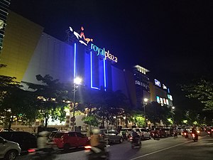
Royal Plaza (Surabaya)
Shopping mall in Surabaya, Indonesia
Distance: Approx. 2526 meters
Latitude and longitude: -7.3091953,112.7344606
Royal Plaza is a shopping center located in Surabaya, East Java. The shopping mall was founded on October 7, 2006. The mall consists of 4 floors with notable tenants namely Matahari Dept.

Jemursari railway station
Railway station in Indonesia
Distance: Approx. 3285 meters
Latitude and longitude: -7.32937,112.731
Jemursari Station (JMS) is an inactive railway station located on the border of Jemur Wonosari and Gayungan. This station was included in the Operation Area VIII Surabaya, to be precise 3 kilometres (1.9 mi) from Wonokromo Station to the south and 2.5 kilometres (1.6 mi) from Waru Station to the north. Jemursari Station was one of the first railway stations in the city of Surabaya which was built in 2003–2004 during the launch of the Delta Ekspres service for the Surabaya–Sidoarjo connection.
St Vincent de Paul Hospital
Hospital in Surabaya, Indonesia
Distance: Approx. 3459 meters
Latitude and longitude: -7.291,112.7362
St Vincent de Paul's Hospital (Indonesian: Rumah Sakit Katolik St. Vincentius a Paulo), or popularly known by its acronym as RKZ (Dutch: St. Vincentius a Paulo Roomsch Katholiek Ziekenhuis, lit. 'St Vincent de Paul Roman Catholic Hospital'), is a large Catholic hospital in Surabaya, Indonesia.
Weather in this IP's area
haze
25 Celsius
26 Celsius
25 Celsius
26 Celsius
1009 hPa
94 %
1009 hPa
1010 hPa
4000 meters
1.54 m/s
230 degree
20 %
