103.5.81.183 - IP Lookup: Free IP Address Lookup, Postal Code Lookup, IP Location Lookup, IP ASN, Public IP
Country:
 New Zealand
Region:
City:
Location:
Time Zone:
Postal Code:
ISP:
ASN:
language:
User-Agent:
Proxy IP:
Blacklist:
IP information under different IP Channel
ip-api
Country
Region
City
ASN
Time Zone
ISP
Blacklist
Proxy
Latitude
Longitude
Postal
Route
db-ip
Country
Region
City
ASN
Time Zone
ISP
Blacklist
Proxy
Latitude
Longitude
Postal
Route
IPinfo
Country
Region
City
ASN
Time Zone
ISP
Blacklist
Proxy
Latitude
Longitude
Postal
Route
IP2Location
103.5.81.183Country
nzRegion
greater wellington
City
petone
Time Zone
ISP
Language
User-Agent
Latitude
Longitude
Postal
ipdata
Country
Region
City
ASN
Time Zone
ISP
Blacklist
Proxy
Latitude
Longitude
Postal
Route
Popular places and events near this IP address

Hutt River (New Zealand)
River in New Zealand
Distance: Approx. 2557 meters
Latitude and longitude: -41.23333333,174.9
The Hutt River (Māori: Te Awa Kairangi, Te Wai o Orutu or Heretaunga; officially Te Awa Kairangi / Hutt River) flows through the southern North Island of New Zealand. It flows south-west from the southern Tararua Range for 56 kilometres (35 mi), forming a number of fertile floodplains, including Kaitoke, central Upper Hutt and Lower Hutt. The Hutt River Trail, a regional park administered by Wellington Regional Council, runs alongside the eastern side of the river.
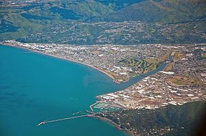
Petone
Suburb of Lower Hutt, New Zealand
Distance: Approx. 749 meters
Latitude and longitude: -41.225,174.878
Petone (Māori: Pito-one) is a large suburb of Lower Hutt, Wellington. It stands at the southern end of the Hutt Valley, on the northern shore of Wellington Harbour. Europeans first settled in Petone in January 1840, making it the oldest European settlement in the Wellington Region.

Alicetown
Suburb of Lower Hutt, New Zealand
Distance: Approx. 2178 meters
Latitude and longitude: -41.21638889,174.89083333
Alicetown is a central suburb of Lower Hutt located at the bottom of the North Island of New Zealand. The suburb is situated north of the major suburb of Petone and west of the Lower Hutt CBD. Its boundaries are the Ewen Bridge that crosses the Hutt River, New Zealand to the east, the Western Hutt Rd/Melling Railway track to the west, Wakefield St/Hutt Railway track to the south and Railway Ave to the north.

Wellington Institute of Technology
Distance: Approx. 1289 meters
Latitude and longitude: -41.2244,174.8847
The Wellington Institute of Technology, also known as WelTec, is a New Zealand polytechnic based in Petone, Lower Hutt. WelTec was formed in 2001 by an amalgamation between the Central Institute of Technology (established in 1960) and the Hutt Valley Polytechnic (established in 1904) In 2020, WelTec, along with 15 other national polytechnics, became subsidiaries of Te Pūkenga – New Zealand Institute of Skills and Technology. WelTec delivers vocational education to about 8,000 students every year.

Mokopuna Island
Island in New Zealand
Distance: Approx. 2434 meters
Latitude and longitude: -41.25,174.86666667
Mokopuna (the 'grandchild') Island is a small uninhabited island in Wellington Harbour, New Zealand. It is about 200 metres (219 yd) on its long axis and about 80 metres (87 yd) across. It lies immediately north of the much larger Matiu/Somes Island, from which it is separated by a channel about 50 metres (55 yd) wide.

Petone Workshops
Distance: Approx. 673 meters
Latitude and longitude: -41.22303889,174.86624444
The Petone Workshops were a government-owned railways maintenance and repair facility located in Petone, in Lower Hutt in the Wellington region of New Zealand's North Island. It took over construction and maintenance of rolling stock in the Wellington region from the Pipitea Point facility, starting in 1876, and became the only such facility in the region from 1878 until the opening of the replacement Hutt Workshops facility in 1929.
Maungaraki
Suburb of Lower Hutt, New Zealand
Distance: Approx. 2339 meters
Latitude and longitude: -41.20833333,174.87888889
Maungaraki is a suburb of Lower Hutt. It is one of several Lower Hutt suburbs on the western hills of the Hutt Valley. It contains the largest suburban development on the Hutt Valley's western escarpment that runs along the Wellington Fault.
Korokoro, New Zealand
Suburb of Lower Hutt, New Zealand
Distance: Approx. 1484 meters
Latitude and longitude: -41.215,174.869
Korokoro, a suburb of Lower Hutt City, lies in the south of the North Island of New Zealand. The suburb occupies part of the western hills of the Hutt Valley; its eastern slopes overlook Petone and the Wellington harbour. Korokoro was established in the 1900s by the Liberal government (in office 1891–1912), and remained a relatively small settlement until the Lower Hutt City Council developed the area for private housing in the 1960s.

Petone Recreation Ground
Distance: Approx. 1174 meters
Latitude and longitude: -41.22353611,174.88270833
Petone Recreation Ground is a cricket ground in Lower Hutt, Wellington, New Zealand. The first recorded match held on the ground came in 1951 when Hutt Valley played Wanganui in the 1950/51 Hawke Cup. The ground later held its first first-class match during the 1991/92 Shell Trophy when Wellington played Otago, with the match ending in an 8 wicket victory for Otago.

Petone Settlers Museum
Memorial in Lower Hutt, New Zealand
Distance: Approx. 842 meters
Latitude and longitude: -41.229272,174.880177
Petone Settlers Museum is a local history museum located in the Wellington Provincial Centennial Memorial, a historic building in Petone, Lower Hutt, New Zealand. The building was originally constructed to mark the Wellington province's centennial commemorations; the museum opened in the building in 1977. The building was extensively refurbished in 2016.

Memorial Park, Lower Hutt
Sports venue in Lower Hutt, New Zealand
Distance: Approx. 2081 meters
Latitude and longitude: -41.2238345,174.8943302
Memorial Park is a venue for football matches in Lower Hutt, New Zealand. It is the home of Petone FC who have been based there since 1961 as well as Capital Football who look after the game for the Wellington Region. The ground was also the training base and home ground for the National Women's team Capital Football who play in New Zealand's highest level domestic competition, the National Women's League.

Waiwhetu Aquifer
Aquifer in Wellington, New Zealand
Distance: Approx. 1818 meters
Latitude and longitude: -41.233,174.891
The Waiwhetu artesian aquifer, sometimes referred to as the Hutt aquifer, is a pressurized zone of water-retaining sand, gravel and boulders beneath the Hutt Valley and Wellington Harbour in New Zealand. The aquifer provides about 40% of the public fresh water supply for Lower Hutt and Wellington city. Water from the Hutt River begins to flow underground south from Taita Gorge, then becomes pressurized under a seal of clay.
Weather in this IP's area
broken clouds
19 Celsius
19 Celsius
19 Celsius
19 Celsius
1017 hPa
82 %
1017 hPa
995 hPa
10000 meters
5.66 m/s
10 degree
75 %