103.48.8.200 - IP Lookup: Free IP Address Lookup, Postal Code Lookup, IP Location Lookup, IP ASN, Public IP
Country:
Region:
City:
Location:
Time Zone:
Postal Code:
ISP:
ASN:
language:
User-Agent:
Proxy IP:
Blacklist:
IP information under different IP Channel
ip-api
Country
Region
City
ASN
Time Zone
ISP
Blacklist
Proxy
Latitude
Longitude
Postal
Route
db-ip
Country
Region
City
ASN
Time Zone
ISP
Blacklist
Proxy
Latitude
Longitude
Postal
Route
IPinfo
Country
Region
City
ASN
Time Zone
ISP
Blacklist
Proxy
Latitude
Longitude
Postal
Route
IP2Location
103.48.8.200Country
Region
taranaki
City
new plymouth
Time Zone
Pacific/Auckland
ISP
Language
User-Agent
Latitude
Longitude
Postal
ipdata
Country
Region
City
ASN
Time Zone
ISP
Blacklist
Proxy
Latitude
Longitude
Postal
Route
Popular places and events near this IP address

New Plymouth
City in Taranaki, New Zealand
Distance: Approx. 1269 meters
Latitude and longitude: -39.05777778,174.07416667
New Plymouth (Māori: Ngāmotu) is the major city of the Taranaki region on the west coast of the North Island of New Zealand. It is named after the English city of Plymouth, in Devon, from where the first English settlers to New Plymouth migrated. The New Plymouth District, which includes New Plymouth City and several smaller towns, is the 10th largest district (out of 67) in New Zealand, and has a population of 90,000 – about two-thirds of the total population of the Taranaki Region and 1.7% of New Zealand's population.

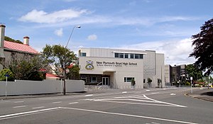
New Plymouth Boys' High School
School
Distance: Approx. 665 meters
Latitude and longitude: -39.0613,174.0866
New Plymouth Boys' High School is a single-sex boys' state secondary school in New Plymouth, Taranaki, New Zealand. The school currently caters for approximately 1300 students, including 210 boarders, on its 15 hectares (37 acres) site. The school often collaborates with the very close-by New Plymouth Girls' High School.

New Plymouth Observatory
Observatory
Distance: Approx. 942 meters
Latitude and longitude: -39.0627,174.0737
New Plymouth Observatory was opened in 1920 and is situated on Marsland Hill (Pūkākā), Robe Street, New Plymouth, New Zealand, and is the home of the New Plymouth Astronomical Society (NPAS). The Society opens the Observatory to the Public, Tuesday evenings. Winter hours are 7.30-9.00pm.
New Plymouth District Council
Distance: Approx. 1108 meters
Latitude and longitude: -39.0593996,174.0745926
New Plymouth District Council (Māori: Te Kaunihera ā-Rohe o Ngāmotu) is the territorial authority for the New Plymouth District of New Zealand. The council consists of the mayor of New Plymouth, Neil Holdom, and 14 ward councillors.

Welbourn, New Zealand
Suburb of New Plymouth, New Zealand
Distance: Approx. 807 meters
Latitude and longitude: -39.06944444,174.09194444
Welbourn (often misspelled Welbourne) is a suburb of New Plymouth, in the western North Island of New Zealand. It is located to the southeast of the city centre. Te Henui Stream runs through the suburb and State Highway 3 forms its western boundary.

Brooklands, New Plymouth
Suburb in New Plymouth, New Zealand
Distance: Approx. 465 meters
Latitude and longitude: -39.07,174.08
Brooklands is a suburb of New Plymouth, in the Taranaki region of the western North Island of New Zealand. It is located on the southern edge of the city and east of Vogeltown. The area is named after Brooklands farm, established in 1842.

Pukekura Park
Botanic garden and park near New Plymouth, New Zealand
Distance: Approx. 417 meters
Latitude and longitude: -39.06444444,174.07944444
Pukekura Park is a Garden of National Significance, covering 52 hectares in the heart of New Plymouth, Taranaki in New Zealand.

TSB Stadium
Indoor stadium located in New Zealand
Distance: Approx. 122 meters
Latitude and longitude: -39.06638889,174.08194444
TSB Stadium is an indoor stadium located adjacent to Pukekura Park in New Plymouth, Taranaki, New Zealand, with vehicle access off Rogan Street.

Festival of Lights (New Plymouth)
Distance: Approx. 417 meters
Latitude and longitude: -39.06444444,174.07944444
The TSB Festival of Lights is an annual event held in Pukekura Park, New Plymouth. Running for free every year from mid-December to late January, it has a daytime and night time programme of events for people of all ages, with light installations illuminating the park. In 2021 the festival won the Best Local Government and NZ's Favourite Event Awards at the 2021 NZ Events Association Awards.

Taranaki Cathedral
Historic church in New Plymouth, New Zealand
Distance: Approx. 1137 meters
Latitude and longitude: -39.060271,174.07308
The Taranaki Cathedral Church of St Mary (formerly known as St Mary's Church) is a historic Anglican cathedral church, located at 37 Vivian Street, New Plymouth, in New Zealand. The cathedral is the oldest stone church in New Zealand and is listed by Heritage New Zealand (formerly New Zealand Historic Places Trust) as a Category 1 Historic Place. At the same time, it is one of the newest cathedrals in the Anglican Communion.

Boer War Memorial, New Plymouth
War memorial in New Plymouth, New Zealand
Distance: Approx. 1009 meters
Latitude and longitude: -39.06135889,174.07386194
The Boer War Memorial from New Plymouth, New Zealand, is a Category 2 heritage place registered by Heritage New Zealand, situated on Marsland Hill. It was erected and unveiled in January 1911 in the memory of Taranaki men who fell in the South African Wars (1899 – 1908).

New Zealand Wars Memorial, New Plymouth
New Zealand Wars Memorial on Marsland Hill, New Plymouth
Distance: Approx. 1009 meters
Latitude and longitude: -39.06135889,174.07386194
The New Zealand Wars Memorial in New Plymouth, New Zealand, is a Category 1 historic place registered by Heritage New Zealand, situated on Marsland Hill. Dedicated to the memory of the men who died during the New Zealand Wars, it was unveiled during a ceremony in May 1909.
Weather in this IP's area
overcast clouds
17 Celsius
16 Celsius
17 Celsius
17 Celsius
1015 hPa
71 %
1015 hPa
996 hPa
10000 meters
2.06 m/s
4.91 m/s
119 degree
90 %