Country:
 Hong Kong (China)
Region:
City:
Latitude and Longitude:
Time Zone:
Postal Code:
IP information under different IP Channel
ip-api
Country
Region
City
ASN
Time Zone
ISP
Blacklist
Proxy
Latitude
Longitude
Postal
Route
IPinfo
Country
Region
City
ASN
Time Zone
ISP
Blacklist
Proxy
Latitude
Longitude
Postal
Route
MaxMind
Country
Region
City
ASN
Time Zone
ISP
Blacklist
Proxy
Latitude
Longitude
Postal
Route
Luminati
Country
HKASN
Time Zone
Asia/Hong_Kong
ISP
Netsec Limited
Latitude
Longitude
Postal
db-ip
Country
Region
City
ASN
Time Zone
ISP
Blacklist
Proxy
Latitude
Longitude
Postal
Route
ipdata
Country
Region
City
ASN
Time Zone
ISP
Blacklist
Proxy
Latitude
Longitude
Postal
Route
Popular places and events near this IP address

Lai Chi Kok station
MTR station in Kowloon, Hong Kong
Distance: Approx. 299 meters
Latitude and longitude: 22.3373,114.1482
Lai Chi Kok (Chinese: 茘枝角) is a rapid transit station on the Tsuen Wan line of the Hong Kong MTR system, between Cheung Sha Wan and Mei Foo stations. It was opened on 17 May 1982. The station is in an orange-red colour, and is a simple through station with an island platform.

Cheung Sha Wan station
MTR station in Kowloon, Hong Kong
Distance: Approx. 562 meters
Latitude and longitude: 22.3354,114.1563
Cheung Sha Wan (Chinese: 長沙灣) is an underground station located underneath Cheung Sha Wan Road in Sham Shui Po District on the Tsuen Wan line of Hong Kong MTR, between Sham Shui Po and Lai Chi Kok. It was opened on 17 May 1982. The station's colour is yellow and brown.

Caritas Medical Centre
Hospital in Kowloon, Hong Kong
Distance: Approx. 534 meters
Latitude and longitude: 22.3411111,114.1527778
Caritas Medical Centre (Chinese: 明愛醫院; Cantonese Yale: Mìhng'oi Yīyún) is a Roman Catholic founded district general hospital in So Uk, Cheung Sha Wan, New Kowloon, Hong Kong. It is the largest hospital in Sham Shui Po District and co-managed by the Hospital Authority and Caritas Hong Kong.

Ching Cheung Road
Road in Hong Kong
Distance: Approx. 571 meters
Latitude and longitude: 22.3405,114.1474
Ching Cheung Road (Chinese: 呈祥道; Jyutping: ching4 cheung4 dou6), part of the Route 7, is a dual carriageway in New Kowloon, Hong Kong linking Lung Cheung Road and Tai Po Road near Tai Wo Ping and Kwai Chung Road of Route 5 near Lai Chi Kok, varying between 2+2 lanes and 3+4 lanes for its length. This road was named in honour of Sir David Trench, the Governor of Hong Kong when it was finished, and the road's name was derived from the connection of his Chinese name (戴麟趾) and the proverb “麟趾呈祥” (Jyutping: lun4 zi2 cing4 coeng4). Kwun Tong (connected by Lung Cheung Road and Kwun Tong Road) in eastern New Kowloon was the main manufacturing centre of Hong Kong during the 1960s.

Tack Ching Girls' Secondary School
Secondary school in Hong Kong
Distance: Approx. 567 meters
Latitude and longitude: 22.3317,114.1495
Tack Ching Girls' Secondary School (Chinese: 德貞女子中學) is a girls school in the Sham Shui Po District of Kowloon, Hong Kong. In 2004 The school was relocated to a new school building at Hing Wah Street West and Sham Mong Road in Cheung Sha Wan.
So Uk
Distance: Approx. 636 meters
Latitude and longitude: 22.3411,114.1548
So Uk (Chinese: 蘇屋; Cantonese Yale: Sōuūk) is an area in New Kowloon of Hong Kong, located to the north of Cheung Sha Wan. It was originally a village founded and resided by a clan bearing the surname So. The area now includes the area surrounding So Uk Estate, and a major hospital, Caritas Medical Centre, is also located within the area.
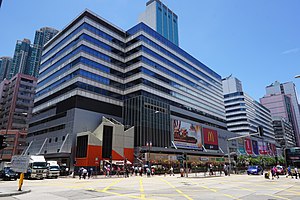
Cheung Sha Wan Plaza
Shopping centre in Cheung Sha Wan, Hong Kong
Distance: Approx. 246 meters
Latitude and longitude: 22.3371,114.14867
Cheung Sha Wan Plaza (Chinese: 長沙灣廣場; Cantonese Yale: chēuhng sā wāhn gwóng chēuhng, Jyutping: coeng4 saa1 waan1 gwong2 coeng4) is shopping centre and office complex in Cheung Sha Wan, New Kowloon, Hong Kong. It was developed by Lai Sun Development in 1989. It is erected over MTR Lai Chi Kok station, consisting of a bus terminus, multi-storey car parks, a commercial/retail podium and two office towers.

Cheung Sha Wan Factory Estate
Distance: Approx. 652 meters
Latitude and longitude: 22.335637,114.157249
Cheung Sha Wan Factory Estate (Chinese: 長沙灣工廠大廈) was a factory estate in Cheung Sha Wan, Kowloon, Hong Kong, owned and managed by the Hong Kong Housing Authority. It comprised up to six low-storey blocks without lift service, built between 1957 and 1965. Cheung Sha Wan Factory Estate was the first factory estate in Hong Kong built in Hong Kong by the Public Works Department.

Sham Shui Po Sports Ground
Sports ground in Kowloon, Hong Kong
Distance: Approx. 129 meters
Latitude and longitude: 22.337068,114.152142
Sham Shui Po Sports Ground (Chinese: 深水埗運動場) is public sports ground located in Cheung Sha Wan, Kowloon, Hong Kong. It opened on 9 January 1988.

Un Chau Estate
Housing estate in Cheung Sha Wan, Hong Kong
Distance: Approx. 539 meters
Latitude and longitude: 22.336917,114.156219
Un Chau Estate (Chinese: 元州邨), or Un Chau Street Estate (Chinese: 元州街邨) before redevelopment, is a public housing estate on the reclaimed land of Cheung Sha Wan, Kowloon, Hong Kong, located between Un Chau Street and Cheung Sha Wan Road, next to MTR Cheung Sha Wan station. It consists of 10 residential buildings completed in 1998, 1999 and 2008, which were developed into 4 phases. Phase 5 was developed on the site of the former Cheung Sha Wan Factory Estate.

Cheung Sha Wan Estate
Public housing estate in Cheung Sha Wan, Hong Kong
Distance: Approx. 590 meters
Latitude and longitude: 22.3345321,114.1562719
Cheung Sha Wan Estate (Chinese: 長沙灣邨) is a public housing estate in Cheung Sha Wan, Kowloon, Hong Kong, built on the site of the former Cheung Sha Wan Police Married Quarters near Cheung Sha Wan station. The estate consists of two residential blocks and an auxiliary facilities block linked to Un Chau Estate by a walkway spanning Cheung Sha Wan Road completed in 2013.
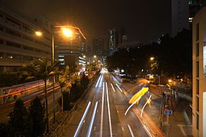
Cheung Sha Wan Road
Road in Kowloon, Hong Kong
Distance: Approx. 565 meters
Latitude and longitude: 22.33540883,114.156334
Cheung Sha Wan Road (Chinese: 長沙灣道; Jyutping: coeng4 saa1 waan4 dou6) is a main thoroughfare in Kowloon, Hong Kong going in a south-north direction from Mong Kok in the south to Lai Chi Kok in the north.
Weather in this IP's area
broken clouds
29 Celsius
35 Celsius
27 Celsius
30 Celsius
1002 hPa
84 %
1002 hPa
1000 hPa
10000 meters
2.68 m/s
4.47 m/s
135 degree
57 %
06:11:34
18:22:12