103.43.79.80 - IP Lookup: Free IP Address Lookup, Postal Code Lookup, IP Location Lookup, IP ASN, Public IP
Country:
Region:
City:
Location:
Time Zone:
Postal Code:
ISP:
ASN:
language:
User-Agent:
Proxy IP:
Blacklist:
IP information under different IP Channel
ip-api
Country
Region
City
ASN
Time Zone
ISP
Blacklist
Proxy
Latitude
Longitude
Postal
Route
db-ip
Country
Region
City
ASN
Time Zone
ISP
Blacklist
Proxy
Latitude
Longitude
Postal
Route
IPinfo
Country
Region
City
ASN
Time Zone
ISP
Blacklist
Proxy
Latitude
Longitude
Postal
Route
IP2Location
103.43.79.80Country
Region
champasak
City
pakse
Time Zone
Asia/Vientiane
ISP
Language
User-Agent
Latitude
Longitude
Postal
ipdata
Country
Region
City
ASN
Time Zone
ISP
Blacklist
Proxy
Latitude
Longitude
Postal
Route
Popular places and events near this IP address

Pakse
District & municipality in Champasak province, Laos
Distance: Approx. 5 meters
Latitude and longitude: 15.11666667,105.78333333
Pakse (or Pakxe; French: Paksé; Laotian: ປາກເຊ [pȁːk séː] 'mouth of the river'; Thai: ปากเซ) is the capital and most populous city of the southern Laotian province of Champasak. Located at the confluence of the Xe Don and Mekong Rivers, the district had a population of approximately 77,900 at the 2015 Laotian census. Pakse was the capital of the Kingdom of Champasak until it was unified with the rest of Laos in 1946.

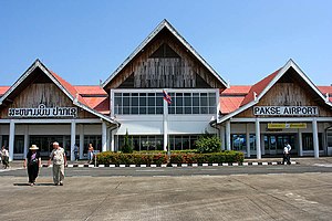
Pakse International Airport
Airport in Pakxe, Laos
Distance: Approx. 1919 meters
Latitude and longitude: 15.13388889,105.78194444
Pakse International Airport (IATA: PKZ, ICAO: VLPS) is one of the four international airports in Laos. Pakse is the former southern capital city of the Kingdom of Champasak.
Champasak Provincial Museum
Distance: Approx. 3097 meters
Latitude and longitude: 15.11833,105.8120673
The Champasak Provincial Museum is a local museum in Pakse, Laos. It holds the unique history of the province, which gathers all kind of artifacts and documents to chronicle the history of Champasak. The museum also holds historical photos of cultural events, foreign meetings and pictures of Kaysone Phomvihane, Nouhak Phoumsavan and Khamtay Siphandone, all from the south.

Champasak Stadium
Distance: Approx. 3561 meters
Latitude and longitude: 15.11833333,105.81638889
The Champasak Stadium or Champassack Stadium is a football stadium in Pakse, Laos. It is the home of Champasak F.C and it is located just north of the Daoruang Market. It has blue and green tribunes and a proper running track around the field.

Lao Airlines Flight 301
2013 aviation accident
Distance: Approx. 6656 meters
Latitude and longitude: 15.15166667,105.73305556
Lao Airlines Flight 301 was a scheduled domestic passenger flight from Vientiane to Pakse, Laos. On 16 October 2013, the ATR 72-600 aircraft operating the flight crashed into the Mekong River near Pakse, killing all 49 people on board. The accident was the first involving an ATR 72-600 and the deadliest ever to occur on Lao soil.
Weather in this IP's area
clear sky
20 Celsius
20 Celsius
20 Celsius
20 Celsius
1013 hPa
66 %
1013 hPa
991 hPa
10000 meters
8.63 m/s
14.24 m/s
23 degree
1 %