Country:
 Australia
Region:
City:
Latitude and Longitude:
Time Zone:
Postal Code:
IP information under different IP Channel
ip-api
Country
Region
City
ASN
Time Zone
ISP
Blacklist
Proxy
Latitude
Longitude
Postal
Route
IPinfo
Country
Region
City
ASN
Time Zone
ISP
Blacklist
Proxy
Latitude
Longitude
Postal
Route
MaxMind
Country
Region
City
ASN
Time Zone
ISP
Blacklist
Proxy
Latitude
Longitude
Postal
Route
Luminati
Country
AUASN
Time Zone
Australia/Sydney
ISP
TPG Telecom Limited
Latitude
Longitude
Postal
db-ip
Country
Region
City
ASN
Time Zone
ISP
Blacklist
Proxy
Latitude
Longitude
Postal
Route
ipdata
Country
Region
City
ASN
Time Zone
ISP
Blacklist
Proxy
Latitude
Longitude
Postal
Route
Popular places and events near this IP address
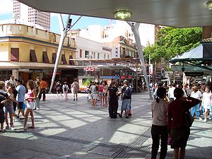
Queen Street bus station
Bus station in Brisbane, Queensland
Distance: Approx. 86 meters
Latitude and longitude: -27.47027778,153.02516667
Queen Street bus station is the primary bus terminus in Brisbane central business district in Queensland, Australia. It is underneath Uptown, Brisbane (formerly the Myer Centre) & Queen Street Mall. It opened on 26 March 1988 along with the Myer Centre.

2005 Brisbane bomb hoax
Distance: Approx. 113 meters
Latitude and longitude: -27.47,153.025
The 2005 Brisbane bomb hoax involved several bomb threats that were made to police in Brisbane, Queensland, Australia on 14 and 15 November 2005. The threats resulted in the halting of public transport services throughout the city.

Uptown, Brisbane
Shopping mall in Queensland, Australia
Distance: Approx. 96 meters
Latitude and longitude: -27.47,153.02520833
Uptown is a six-floor shopping complex located on the Queen Street Mall in the central business district of Brisbane, Queensland, Australia. The centre was named The Myer Centre from its opening in 1988 to 2023 as it used to house Queensland's largest Myer department store.
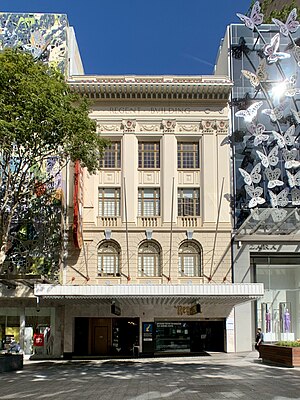
Regent Theatre, Brisbane
Heritage-listed cinema in Brisbane, Queensland
Distance: Approx. 123 meters
Latitude and longitude: -27.4694,153.0261
Regent Theatre was a heritage-listed cinema at 167 Queen Street, Brisbane, Australia. It was designed by Richard Gailey, Charles N Hollinshed and Aaron Bolot and built from 1928 to 1929 by J & E L Rees and A J Dickenson. It was one of the original Hoyts' Picture Palaces from the 1920s.
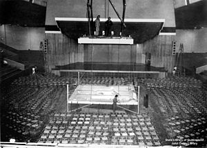
Brisbane Festival Hall
Multi-purpose arena located in the Brisbane, Australia
Distance: Approx. 72 meters
Latitude and longitude: -27.470779,153.026657
Brisbane Festival Hall was an indoor arena located on the southern corner of Albert Street and Charlotte Street, Brisbane, Queensland, Australia. It operated from 1910 to 2003, before being demolished to make the Oak Festival Towers apartment building and hotel.

T & G Building, Brisbane
Building in Brisbane, Queensland
Distance: Approx. 90 meters
Latitude and longitude: -27.46974444,153.02566667
The T & G Building was a notable office block, located on the corner of Queen Street and Albert Street in Brisbane, Queensland, Australia, built for the T&G (Temperance and General) Mutual Life Assurance Society Company in 1924.

Elizabeth Street, Brisbane
Street in Brisbane, Queensland
Distance: Approx. 22 meters
Latitude and longitude: -27.4703,153.026
Elizabeth Street is a major street in the centre of the city in Brisbane, Queensland, Australia. The street was one of the earliest in Brisbane being established at the beginning of settlement in Brisbane as Moreton Bay penal settlement. Today, most of the street is fronted by low-level retail outlets, with an increase in mixed use skyscrapers being recently constructed.
123 Albert Street
Skyscraper in Brisbane, Queensland
Distance: Approx. 78 meters
Latitude and longitude: -27.47075278,153.02673889
123 Albert Street is a commercial office development in Brisbane, Australia. The modern style office building is located in the Brisbane central business district at 123 Albert Street. The building was completed in July 2011 and opened in October 2011.

Great fire of Brisbane
Distance: Approx. 96 meters
Latitude and longitude: -27.47047,153.02503
The Great fire of Brisbane was a major conflagration that swept through the central parts of Brisbane in the Colony of Queensland (now a state of Australia) on 1 December 1864. For two and a half hours the fire burned out of control in large parts of Brisbane's central business district with entire blocks being destroyed, mainly in Queen, Albert, George, and Elizabeth Streets. It consumed 50 houses, 2 banks, 3 hotels, 4 draperies, and many other businesses as well as a "considerable amount of small houses".

Perry House, Brisbane
Heritage-listed building in Brisbane, Queensland
Distance: Approx. 41 meters
Latitude and longitude: -27.4704,153.0264
Perry House is a heritage-listed office building at 167 Albert Street (corner of Elizabeth Street), Brisbane City, Queensland, Australia. It was designed by Claude William Chambers and built from 1911 to 1923 by Thomas Keenan. It is also known as Royal Albert Apartments.

Heckelmanns Building
Heritage-listed building in Brisbane, Queensland
Distance: Approx. 113 meters
Latitude and longitude: -27.47,153.027
Heckelmanns Building is a heritage-listed warehouse at 171 Elizabeth Street, Brisbane City, City of Brisbane, Queensland, Australia. It was designed by Andrea Giovanni Stombuco and built from 1884 to 1891. It was added to the Queensland Heritage Register on 21 October 1992.

Theatre Royal, Brisbane
Former theatre in Queensland, Australia
Distance: Approx. 30 meters
Latitude and longitude: -27.4705,153.0257
The Theatre Royal was the second dedicated theatre built in Brisbane, Queensland, Australia. It opened in 1881 and was designed by Andrea Stombuco. The first venue on the same site was Mason's Concert [or Music] Hall (1865), which had been designed William (Billy) Coote and constructed by John Bourne.
Weather in this IP's area
overcast clouds
17 Celsius
17 Celsius
16 Celsius
19 Celsius
1020 hPa
93 %
1020 hPa
1019 hPa
10000 meters
1.34 m/s
3.13 m/s
187 degree
100 %
05:18:09
17:51:52