103.42.252.210 - IP Lookup: Free IP Address Lookup, Postal Code Lookup, IP Location Lookup, IP ASN, Public IP
Country:
 Indonesia
Region:
City:
Location:
Time Zone:
Postal Code:
ISP:
ASN:
language:
User-Agent:
Proxy IP:
Blacklist:
IP information under different IP Channel
ip-api
Country
Region
City
ASN
Time Zone
ISP
Blacklist
Proxy
Latitude
Longitude
Postal
Route
db-ip
Country
Region
City
ASN
Time Zone
ISP
Blacklist
Proxy
Latitude
Longitude
Postal
Route
IPinfo
Country
Region
City
ASN
Time Zone
ISP
Blacklist
Proxy
Latitude
Longitude
Postal
Route
IP2Location
103.42.252.210Country
idRegion
sulawesi utara
City
bitung
Time Zone
Asia/Makassar
ISP
Language
User-Agent
Latitude
Longitude
Postal
ipdata
Country
Region
City
ASN
Time Zone
ISP
Blacklist
Proxy
Latitude
Longitude
Postal
Route
Popular places and events near this IP address
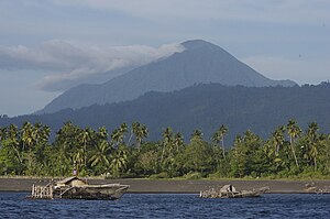
Mount Tangkoko
Stratovolcano on Sulawesi, Indonesia
Distance: Approx. 8120 meters
Latitude and longitude: 1.518,125.185
Mount Tangkoko is a stratovolcano in the north of Sulawesi island in Indonesia. Its summit has an elongated deep crater.On the east flank is a flat lava dome, Batu Angus. Historical records only show eruptions in the 19th century.

Bitung
City in North Sulawesi, Indonesia
Distance: Approx. 1728 meters
Latitude and longitude: 1.44722222,125.19777778
Bitung, officially the City of Bitung (Indonesian: Kota Bitung), is a coastal city at the north-eastern edge of the island of Sulawesi in Indonesia. Bitung is located in the province of North Sulawesi (Sulawesi Utara), and faces Lembeh Island (which forms two districts of the city), and the Lembeh Strait, which is known for its colourful marine life, in particular sea slugs. Bitung has a population of 187,932 at the 2010 Census, making it the second most populated city in the province after the capital Manado, rising to 225,134 at the 2020 Census; the official estimate as at mid 2023 was 232,440 (comprising 119,120 males and 113,330 females).

Tangkoko Batuangus Nature Reserve
Protected area in Sulawesi, Indonesia
Distance: Approx. 7967 meters
Latitude and longitude: 1.51666667,125.18333333
Tangkoko Batuangus Nature Reserve, Indonesian: Tangkoko-Batuangus Dua Saudara is a nature reserve in the northern part of Sulawesi island of Indonesia, 70 kilometres (43 miles) from Manado City. The reserve covers an area of 8,718 hectares (21,540 acres), and includes three mountains: Mount Tangkoko at 1,109 metres (3,638 feet), Mount Dua Saudara at 1,361 metres (4,465 feet), and Mount Batuangus at 450 metres (1,480 feet).

Lembeh Strait
Strait in Indonesia
Distance: Approx. 4415 meters
Latitude and longitude: 1.44972222,125.22180556
Lembeh Strait is a strait in Indonesia, separating the islands of Sulawesi and Lembeh. The town of Bitung and Tongkoko volcano are located on the western side of the strait. The strait is known for its abundant and colorful marine life, in particular sea slugs, and is a popular diving spot.

Port of Bitung
Seaport in North Sulawesi, Indonesia
Distance: Approx. 1696 meters
Latitude and longitude: 1.44305556,125.1975
Port of Bitung (Indonesian: Pelabuhan Bitung) is a seaport located on Jalan D.S Sumolang in Bitung, North Sulawesi, in Indonesia. It is the largest port in the province, consists of both container and passenger ship ports. The port serves as a hub for most exports originated from North Sulawesi and other areas of eastern Indonesia to destinations such as Philippines and Vietnam.
Weather in this IP's area
overcast clouds
29 Celsius
33 Celsius
29 Celsius
29 Celsius
1009 hPa
74 %
1009 hPa
991 hPa
10000 meters
5.57 m/s
6.23 m/s
7 degree
90 %