Country:
 Australia
Region:
City:
Latitude and Longitude:
Time Zone:
Postal Code:
IP information under different IP Channel
ip-api
Country
Region
City
ASN
Time Zone
ISP
Blacklist
Proxy
Latitude
Longitude
Postal
Route
IPinfo
Country
Region
City
ASN
Time Zone
ISP
Blacklist
Proxy
Latitude
Longitude
Postal
Route
MaxMind
Country
Region
City
ASN
Time Zone
ISP
Blacklist
Proxy
Latitude
Longitude
Postal
Route
Luminati
Country
AURegion
nsw
City
sydney
ASN
Time Zone
Australia/Sydney
ISP
TPG Telecom Limited
Latitude
Longitude
Postal
db-ip
Country
Region
City
ASN
Time Zone
ISP
Blacklist
Proxy
Latitude
Longitude
Postal
Route
ipdata
Country
Region
City
ASN
Time Zone
ISP
Blacklist
Proxy
Latitude
Longitude
Postal
Route
Popular places and events near this IP address

Bella Vista, New South Wales
Suburb of Sydney, New South Wales, Australia
Distance: Approx. 243 meters
Latitude and longitude: -33.742,150.955
Bella Vista is located 33 kilometres north-west of the Sydney central business district and is part of The Hills Shire. It is a suburb in the Hills District of Greater Western Sydney and is in the state of New South Wales, Australia. Bella Vista's Norwest Business Park is home to several Fortune 500 companies, a number of shopping centres, high-rise buildings, and industrial and recreational spaces.
Crestwood, Sydney
Suburb of Sydney, New South Wales, Australia
Distance: Approx. 1856 meters
Latitude and longitude: -33.743,150.974
Crestwood is an urban place in Sydney, New South Wales, Australia. Crestwood is located in the suburb of Baulkham Hills in the local government area of The Hills Shire.

Norwest Business Park
Distance: Approx. 1130 meters
Latitude and longitude: -33.73333333,150.96361111
The Norwest Business Park is a business park in the suburbs of Norwest and Bella Vista in the local government area of The Hills Shire in Sydney, New South Wales, Australia. Norwest Business Park is bordered by Windsor Road to the east, and Old Windsor Road to the west, with Norwest Boulevard stretching the length of the park between the two main arterial roads. Over 400 companies are located in the park, employing more than 25,000 people.
Glenwood High School (Australia)
Public, co-educational, day school in Glenwood, New South Wales, Australia
Distance: Approx. 1743 meters
Latitude and longitude: -33.73286,150.93748
Glenwood High School is a public high school located in Glenwood, New South Wales, Australia. It opened in 2005 with 490 students across two grades, Year 7 and Year 8. As of 2022 it had 1500+ students across Years 7–12.
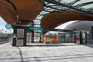
Norwest railway station
Sydney Metro railway station
Distance: Approx. 1091 meters
Latitude and longitude: -33.734251,150.963931
Norwest railway station is an underground Sydney Metro station on Brookhollow Avenue in Norwest, New South Wales, Australia. The station serves the Metro North West & Bankstown Line and was built as part of the Sydney Metro Northwest project. The station is planned to eventually serve trains to the Sydney central business district and Bankstown as part of the government's 20-year Sydney's Rail Future strategy.
Sydney Ice Arena
Sport venue in Australia
Distance: Approx. 1107 meters
Latitude and longitude: -33.73213,150.96177
Sydney Ice Arena was an ice sports and public ice skating centre, located in Norwest, New South Wales. It hosted a number of major events, including Australian Ice Hockey League games. A development application was submitted by property owner Hillsong, seeking to demolish the arena to make way for apartment blocks with retail facilities, and was approved by council.

Bella Vista railway station
Sydney Metro railway station
Distance: Approx. 1521 meters
Latitude and longitude: -33.72958,150.943535
Bella Vista railway station is a Sydney Metro station on the western edge of the Norwest Business Park in Sydney, Australia. The station serves the Metro North West & Bankstown Line and was built as part of the Sydney Metro Northwest project. The station is planned to eventually serve trains to the Sydney central business district and Bankstown as part of the government's 20-year Sydney's Rail Future strategy.

Exeter Farm
Heritage-listed residence in Glenwood, Sydney, built in 1845-1860
Distance: Approx. 1927 meters
Latitude and longitude: -33.7417,150.9336
Exeter Farm is a heritage-listed residence at 2 Knightsbridge Avenue, Glenwood, City of Blacktown, Sydney, New South Wales, Australia. It was built from 1845 to 1860. It is also known as Meurant's Cottage.

Norwest, New South Wales
Suburb of Sydney, New South Wales, Australia
Distance: Approx. 1150 meters
Latitude and longitude: -33.73305556,150.96361111
Norwest is a suburb of the Hills District within Greater Western Sydney, in the state of New South Wales, Australia, located 35 kilometres north-west of the Sydney central business district. The Norwest Business Park is located within Norwest and the adjacent suburb of Bella Vista and Baulkham Hills. The council chambers for The Hills Shire Council are also located within this suburb.
Bella Vista (homestead)
Historic site in New South Wales, Australia
Distance: Approx. 146 meters
Latitude and longitude: -33.7403,150.9528
Bella Vista is a heritage-listed residence at Elizabeth Macarthur Drive, Bella Vista, The Hills Shire, New South Wales, Australia. It was built from 1830 to 1960. It is also known as Kings Langley, Stock Farm, Seven Hills Farm and Bella Vista Farm.

Pearce Family Cemetery
Historic site in New South Wales, Australia
Distance: Approx. 1922 meters
Latitude and longitude: -33.7571,150.9561
The Pearce Family Cemetery is a heritage-listed former farming land and now cemetery located at 257 Seven Hills Road, Bella Vista in The Hills Shire local government area of New South Wales, Australia. It is also known as the Pearce Cemetery. The property is privately owned.
Valentine Sports Park
Australian soccer stadium
Distance: Approx. 882 meters
Latitude and longitude: -33.7396608,150.9447775
Valentine Sports Park is an Australian football stadium in Glenwood, a suburb of Sydney. It is the home of Football NSW. The venue received a $22 million transformation and was officially re-opened in March 2015. The impressive facility features five full-sized football fields all aligned to FIFA specifications, including three natural grass fields and two synthetic fields, all of which have lighting, six player change rooms and a multi-purpose indoor sports centre featuring an international full-sized futsal court.
Weather in this IP's area
overcast clouds
13 Celsius
12 Celsius
12 Celsius
14 Celsius
1024 hPa
87 %
1024 hPa
1012 hPa
10000 meters
0.45 m/s
1.34 m/s
213 degree
99 %
06:21:10
19:04:56