Country:
 Australia
Region:
City:
Latitude and Longitude:
Time Zone:
Postal Code:
IP information under different IP Channel
ip-api
Country
Region
City
ASN
Time Zone
ISP
Blacklist
Proxy
Latitude
Longitude
Postal
Route
IPinfo
Country
Region
City
ASN
Time Zone
ISP
Blacklist
Proxy
Latitude
Longitude
Postal
Route
MaxMind
Country
Region
City
ASN
Time Zone
ISP
Blacklist
Proxy
Latitude
Longitude
Postal
Route
Luminati
Country
AURegion
nsw
City
sydney
ASN
Time Zone
Australia/Sydney
ISP
TPG Telecom Limited
Latitude
Longitude
Postal
db-ip
Country
Region
City
ASN
Time Zone
ISP
Blacklist
Proxy
Latitude
Longitude
Postal
Route
ipdata
Country
Region
City
ASN
Time Zone
ISP
Blacklist
Proxy
Latitude
Longitude
Postal
Route
Popular places and events near this IP address

Ingleside, New South Wales
Suburb of Sydney, New South Wales, Australia
Distance: Approx. 3184 meters
Latitude and longitude: -33.6823,151.26315
Ingleside is a suburb in Northern Sydney, in the state of New South Wales, Australia. Ingleside is located 28 kilometres north of the Sydney central business district, in the local government area of Northern Beaches Council. Ingleside Heights and Tumbledown Dick are localities in the west of the suburb.
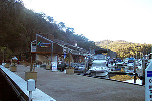
Akuna Bay
Bay in Northern Sydney
Distance: Approx. 4129 meters
Latitude and longitude: -33.64444444,151.23638889
The Akuna Bay is a bay within Broken Bay, located in the Northern Beaches Council local government area in the Northern Suburbs of Sydney, Australia. The bay is fed by Coal and Candle Creek, with its land boundaries encased within the Ku-ring-gai Chase National Park. A large marina in located within the bay.
Akuna Bay, New South Wales
Place in New South Wales, Australia
Distance: Approx. 3718 meters
Latitude and longitude: -33.648,151.235
Akuna Bay is an urban place in Sydney, Australia. Akuna Bay is located 38 kilometres (24 mi) north of the Sydney central business district, in the local government area of Northern Beaches Council. Akuna Bay sits in the Ku-ring-gai Chase National Park and takes its name from the bay on Coal and Candle Creek.

Division of Mackellar
Australian federal electoral division
Distance: Approx. 2609 meters
Latitude and longitude: -33.669,151.253
The Division of Mackellar is an Australian electoral division in the state of New South Wales.

Terrey Hills
Suburb of Sydney, New South Wales, Australia
Distance: Approx. 1148 meters
Latitude and longitude: -33.68888889,151.22083333
Terrey Hills is a suburb of Northern Sydney, in the state of New South Wales, Australia 25 kilometres north of the Sydney central business district in the local government area of Northern Beaches Council. It is part of the Forest District and Northern Beaches region. Terrey Hills is a very leafy suburb and in some areas semi-rural, with many people boarding their horses in the area.
Duffys Forest, New South Wales
Suburb of Sydney, New South Wales, Australia
Distance: Approx. 2935 meters
Latitude and longitude: -33.67525,151.19789
Duffys Forest is a suburb of northern Sydney, in the state of New South Wales, Australia. Duffys Forest is 28 kilometres north of the Sydney central business district in the local government area of Northern Beaches Council. Duffys Forest is considered to be part of the Northern Beaches region and the Forest District.

Northern Beaches Christian School
School in Australia
Distance: Approx. 2613 meters
Latitude and longitude: -33.674039,151.201874
Northern Beaches Christian School is an independent non-denominational Christian co-educational primary and secondary day school, located in Terrey Hills, Sydney, Australia. Established in 1981, the school provides a general and religious education for approximately 1,200 students from Kindergarten to Year 12. The school is affiliated with Macquarie University.
Covenant Christian School, Sydney
School in Belrose, Northern Beaches, Sydney, New South Wales, Australia
Distance: Approx. 3841 meters
Latitude and longitude: -33.71361111,151.21527778
Covenant Christian School is an independent non-denominational Christian co-educational early learning, primary and secondary day school, located in Belrose on the Northern Beaches of Sydney, New South Wales, Australia. The school was established in 1978 and delivers a general and religious education to approximately 850 children from early learning through Kindergarten to Year 12. The school is a member of Christian Education National (formerly Christian Parents Controlled Schools).
Sydney Japanese International School
School in Australia
Distance: Approx. 2561 meters
Latitude and longitude: -33.67555556,151.20194444
The Sydney Japanese International School (abbreviated as SJIS, Japanese: シドニー日本人国際学校, romanized: Shidonī Nihonjin Kokusai Gakkō), formerly known in English as the Sydney Japanese School, and in Japanese as シドニー日本人学校 Shidonī Nihonjin Gakkō, is an independent co-educational Nihonjin gakkō (Japanese international) primary and secondary day school, located in Terrey Hills within the Northern Beaches Council area of Sydney, Australia. The school serves elementary and junior high school levels, from Year K to Year 9. The school accepts non-Japanese students, offering them international classes.
German International School Sydney
School in Terrey Hills, New South Wales, Australia
Distance: Approx. 1212 meters
Latitude and longitude: -33.6889,151.2198
German International School Sydney is a German international school in Terrey Hills, Sydney, New South Wales. It serves from Preschool until IBDP Senior Secondary (Sekundarstufe II).
Sydney Baháʼí Temple
Baháʼí temple in Ingleside, Sydney, Australia
Distance: Approx. 2814 meters
Latitude and longitude: -33.6855,151.2587
The Sydney Baháʼí House of Worship or Sydney Baháʼí Temple is situated in Ingleside, a northern suburb of Sydney, Australia. According to Jennifer Taylor, a historian at Sydney University, it is among Sydney's four most significant religious buildings constructed in the twentieth century. It was the world's fourth Baháʼí House of Worship to be constructed, completed in 1961.
Waratah Park
Fauna sanctuary
Distance: Approx. 4470 meters
Latitude and longitude: -33.6762,151.1809
Waratah Park is a heritage-listed former Aboriginal land and fauna sanctuary and now Aboriginal title claim at 13 Namba Road, Duffys Forest in the Northern Beaches Council local government area of New South Wales, Australia. It is also known for serving as the fictional Waratah National Park, the filming location for the Australian television series Skippy the Bush Kangaroo (produced from 1967 to 1969), when the area was still undeveloped Crown land. After the series ended, the Crown land remained mostly undeveloped, with the government granting management of the area to a series of operators until August 2014, when the government passed full ownership of the land to the Metropolitan Local Aboriginal Land Council.
Weather in this IP's area
overcast clouds
13 Celsius
12 Celsius
12 Celsius
13 Celsius
1024 hPa
82 %
1024 hPa
1000 hPa
10000 meters
0.89 m/s
1.34 m/s
303 degree
92 %
06:20:06
19:03:48