Country:
Region:
City:
Latitude and Longitude:
Time Zone:
Postal Code:
IP information under different IP Channel
ip-api
Country
Region
City
ASN
Time Zone
ISP
Blacklist
Proxy
Latitude
Longitude
Postal
Route
Luminati
Country
ASN
Time Zone
Asia/Bangkok
ISP
Electronics Extreme Co., Ltd
Latitude
Longitude
Postal
IPinfo
Country
Region
City
ASN
Time Zone
ISP
Blacklist
Proxy
Latitude
Longitude
Postal
Route
db-ip
Country
Region
City
ASN
Time Zone
ISP
Blacklist
Proxy
Latitude
Longitude
Postal
Route
ipdata
Country
Region
City
ASN
Time Zone
ISP
Blacklist
Proxy
Latitude
Longitude
Postal
Route
Popular places and events near this IP address

Nonthaburi province
Province of Thailand
Distance: Approx. 2493 meters
Latitude and longitude: 13.8625,100.51444444
Nonthaburi is one of the central provinces (changwat) of Thailand, established by the Act Establishing Changwat Samut Prakan, Changwat Nonthaburi, Changwat Samut Sakhon and Changwat Nakhon Nayok, Buddhist Era 2489 (1946), which came into force on 9 May 1946 (Thursday). Neighboring provinces are (from north clockwise) Phra Nakhon Si Ayutthaya, Pathum Thani, Bangkok, and Nakhon Pathom. Nonthaburi is the most densely populated province after Bangkok.
Klong Prem Central Prison
Prison in Bangkok, Thailand
Distance: Approx. 2268 meters
Latitude and longitude: 13.84722222,100.55388889
Klong Prem Central prison (Thai: เรือนจํากลางคลองเปรม; RTGS: Rueancham Klang Khlong Prem) is a maximum security prison in Chatuchak District, Bangkok, Thailand. The prison has several separate sections. The compound houses up to 20,000 inmates.
Praboromarajchanok Institute
Organization in Nonthaburi, Thailand
Distance: Approx. 529 meters
Latitude and longitude: 13.850242,100.528228
Praboromarajchanok Institute (Thai: สถาบันพระบรมราชชนก) is a public higher education institute for production of public health workforce under the Ministry of Public Health in Thailand. It named after the father of modern medicine and public health in Thailand, Prince Mahidol of Songkhla.

Nonthaburi
City in Thailand
Distance: Approx. 1179 meters
Latitude and longitude: 13.85083333,100.52222222
Nonthaburi (Thai: นนทบุรี, pronounced [nōn.tʰá(ʔ).bū.rīː]) is the principal city of the district and province of the same name in Thailand. On 15 February 1936, Nonthaburi town municipality (thesaban mueang) was established, which only covered Suan Yai subdistrict (tambon), just 2.5 km2 (0.97 sq mi). On 25 September 1995, Nonthaburi was upgraded to city municipality (thesaban nakhon) by enlargement of the city with four more subdistricts, Talat Khwan (8.2 km2 [3.2 sq mi]), Bang Khen (9.0 km2 [3.5 sq mi]), Bang Kraso (11.2 km2 [4.3 sq mi]) and Tha Sai (8.0 km2 [3.1 sq mi]), covering a total of 38.9 km2 (15.0 sq mi).

Nonthaburi Civic Center MRT station
Monorail station in Thailand
Distance: Approx. 2484 meters
Latitude and longitude: 13.8602,100.513
Nonthaburi Civic Center station (Thai: สถานีศูนย์ราชการนนทบุรี, RTGS: Sathani Sun Ratchakan Nonthaburi) is a Bangkok MRT station on the Purple Line and Pink Line. The station is located on the Rattanathibet road in Nonthaburi Province. The station opened on 6 August 2016 on the Purple Line, while the Pink Line opened on 21 November 2023.

Bamrasnaradura Infectious Diseases Institute
Specialised hospital in Thailand
Distance: Approx. 1222 meters
Latitude and longitude: 13.85388889,100.52277778
Bamrasnaradura Infectious Diseases Institute (Thai: สถาบันบำราศนราดูร; RTGS: bamrat naradun) is a specialised hospital for patients infected with highly contagious diseases and used to control the outbreak of the diseases. It was found in 1960 as Bamrasnaradura Hospital. The hospital is currently a division of Department of Disease Control, Ministry of Public Health and located in Nonthaburi Province, Thailand within the headquarters of the ministry itself.

Yaek Tiwanon MRT station
Monorail station in Thailand
Distance: Approx. 2229 meters
Latitude and longitude: 13.8396,100.5149
Yaek Tiwanon station (Thai: สถานีแยกติวานนท์) is a Bangkok MRT station on the Purple Line. The station opened on 6 August 2016 and is located on Bangkok-Nonthaburi road, near its intersection with Tiwanon Road in Nonthaburi Province. The station has four entrances.

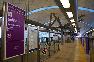
Wong Sawang MRT station
Monorail station in Bangkok, Thailand
Distance: Approx. 2260 meters
Latitude and longitude: 13.8299,100.5265
Wong Sawang station (Thai: สถานีวงศ์สว่าง, pronounced [sā.tʰǎː.nīː wōŋ sā.wàːŋ]) is a Bangkok MRT station on the Purple Line. The station opened on 6 August 2016 and is located on Bangkok-Nonthaburi road, near its intersection with Wong Sawang Road in Bangkok. The station has four entrances.
Srithanya Hospital
Hospital in Nonthaburi, Thailand
Distance: Approx. 1792 meters
Latitude and longitude: 13.846255,100.516697
Srithanya Hospital (Thai: โรงพยาบาลศรีธัญญา) is the largest psychiatric hospital in Thailand, located in Mueang Nonthaburi District, Nonthaburi Province. It is adjacent to the headquarters of the Ministry of Public Health and is operated by the Department of Mental Health (DMH). It is served by Ministry of Public Health MRT station, located in front of the hospital.

Wong Sawang
Khwaeng in Thailand
Distance: Approx. 2377 meters
Latitude and longitude: 13.828303,100.528464
Wong Sawang (Thai: วงศ์สว่าง, pronounced [wōŋ sā.wàːŋ]) is a khwaeng (subdistrict) of two subdistricts of Bang Sue District, Bangkok, apart from Bang Sue Subdistrict. It is also the name of the surrounding area.
Khae Rai
Road junction
Distance: Approx. 1653 meters
Latitude and longitude: 13.85916667,100.52166667
Khae Rai (Thai: แคราย, pronounced [kʰɛ̄ː rāːj]) is the name of a major road intersection and its surrounding neighborhood in downtown Nonthaburi, a northern suburb city of Bangkok and the administrative seat of Nonthaburi province. Formed by the crossing of Ngam Wong Wan/Rattanathibet and Tiwanon roads, it lies within Bang Kraso subdistrict of Mueang Nonthaburi district, and is home to government offices of both the city and the province as well as commercial and residential developments. It serves as a mass transit interchange between the MRT Purple Line and Pink Line, as well as the planned Brown Line.

Khae Rai MRT station
Railway station in Nonthaburi, Thailand
Distance: Approx. 1998 meters
Latitude and longitude: 13.8626,100.5207
Khae Rai station (Thai: สถานีแคราย) is a Bangkok MRT station on the Pink Line. The station is located on Tiwanon Road in Mueang Nonthaburi district, Nonthaburi province. The station has four exits.
Weather in this IP's area
few clouds
30 Celsius
32 Celsius
28 Celsius
30 Celsius
1011 hPa
59 %
1011 hPa
1010 hPa
10000 meters
1.03 m/s
20 %
06:19:19
17:47:04