103.40.125.33 - IP Lookup: Free IP Address Lookup, Postal Code Lookup, IP Location Lookup, IP ASN, Public IP
Country:
Region:
City:
Location:
Time Zone:
Postal Code:
IP information under different IP Channel
ip-api
Country
Region
City
ASN
Time Zone
ISP
Blacklist
Proxy
Latitude
Longitude
Postal
Route
Luminati
Country
ASN
Time Zone
Asia/Tokyo
ISP
BEKKOAME INTERNET INC.
Latitude
Longitude
Postal
IPinfo
Country
Region
City
ASN
Time Zone
ISP
Blacklist
Proxy
Latitude
Longitude
Postal
Route
IP2Location
103.40.125.33Country
Region
shizuoka
City
nishi
Time Zone
Asia/Tokyo
ISP
Language
User-Agent
Latitude
Longitude
Postal
db-ip
Country
Region
City
ASN
Time Zone
ISP
Blacklist
Proxy
Latitude
Longitude
Postal
Route
ipdata
Country
Region
City
ASN
Time Zone
ISP
Blacklist
Proxy
Latitude
Longitude
Postal
Route
Popular places and events near this IP address

Mishima, Shizuoka
City in Chūbu, Japan
Distance: Approx. 2171 meters
Latitude and longitude: 35.1185,138.91855556
Mishima (三島市, Mishima-shi) is a city located in eastern Shizuoka Prefecture, Japan. As of 31 July 2019, the city had an estimated population of 109,803 in 49,323 households, and a population density of 1,800 persons per square kilometre (4,700 per square mile). The total area of the city is 62.02 square kilometres (23.95 sq mi).
Nagaizumi
Town in Japan
Distance: Approx. 875 meters
Latitude and longitude: 35.13766667,138.89716667
Nagaizumi (長泉町, Nagaizumi-chō) is a town located in Suntō District, Shizuoka Prefecture, Japan. As of 1 August 2019, the town had an estimated population of 43,568 in 18154 households and a population density of 1,600 persons per km2. The total area of the town was 26.63 square kilometres (10.28 sq mi).

Mishima Station
Railway station in Mishima, Shizuoka Prefecture, Japan
Distance: Approx. 1070 meters
Latitude and longitude: 35.12722222,138.91055556
Mishima Station (三島駅, Mishima-eki) is a railway station in the city of Mishima, Shizuoka, Japan, operated by the Central Japan Railway Company (JR Central). It is also a union station with the Izuhakone Railway. The station was also a freight terminal of the Japan Freight Railway Company (JR Freight), although freight operations are now only on an occasional basis.

Ōoka Station
Railway station in Numazu, Shizuoka Prefecture, Japan
Distance: Approx. 2305 meters
Latitude and longitude: 35.11583333,138.88083333
Ōoka Station (大岡駅, Ōoka-eki) is a railway station in the city of Numazu, Shizuoka Prefecture, Japan, operated by the Central Japan Railway Company (JR Central).
Nagaizumi-Nameri Station
Railway station in Nagaizumi, Shizuoka Prefecture, Japan
Distance: Approx. 1948 meters
Latitude and longitude: 35.1475,138.89916667
Nagaizumi-Nameri Station (長泉なめり駅, Nagaizumi-Nameri-eki) is a railway station in the town of Nagaizumi, Shizuoka Prefecture, Japan, operated by the Central Japan Railway Company (JR Central).

Shimo-Togari Station
Railway station in Nagaizumi, Shizuoka Prefecture, Japan
Distance: Approx. 367 meters
Latitude and longitude: 35.12972222,138.89527778
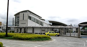
Shimo-Togari Station (下土狩駅, Shimo-Togari-eki) is a railway station in the town of Nagaizumi, Shizuoka Prefecture, Japan, operated by the Central Japan Railway Company (JR Central).

Mishima Taisha
Shinto shrine in Mishima, Shizuoka, Japan
Distance: Approx. 1996 meters
Latitude and longitude: 35.12194444,138.91888889
The Mishima Taisha (三嶋大社) is a Shinto shrine located in the city of Mishima in Shizuoka Prefecture, Japan. It is the ichinomiya of former Izu Province as well as its Sōja shrine. The main festival of the shrine is held annually on August 16, and features yabusame performances.

Mishima-Hirokōji Station
Railway station in Mishima, Shizuoka Prefecture, Japan
Distance: Approx. 1634 meters
Latitude and longitude: 35.11902222,138.91121667
Mishima-Hirokōji Station (三島広小路駅, Mishimahirokōji-eki) is a railway station located in the city of Mishima, Shizuoka Prefecture, Japan operated by the private railroad company Izuhakone Railway.

Mishima-Tamachi Station
Railway station in Mishima, Shizuoka Prefecture, Japan
Distance: Approx. 2265 meters
Latitude and longitude: 35.11654167,138.91796111
Mishima-Tamachi Station (三島田町駅, Mishimatamachi-eki) is a railway station located in the city of Mishima, Shizuoka Prefecture, Japan operated by the private railroad company Izuhakone Railway.

Mishima-Futsukamachi Station
Railway station in Mishima, Shizuoka Prefecture, Japan
Distance: Approx. 3148 meters
Latitude and longitude: 35.11148889,138.92543056
Mishima-Futsukamachi Station (三島二日町駅, Mishimafutsukamachi-eki) is a railway station located in an industrial area of the city of Mishima, Shizuoka Prefecture, Japan operated by the private railroad company Izuhakone Railway.

Sano Art Museum
Art museum in Shizuoka, Japan
Distance: Approx. 2258 meters
Latitude and longitude: 35.114944,138.915917
The Sano Art Museum (佐野美術館, Sano Bijutsukan) is a private art museum, located in the Nakata neighborhood of the city of Mishima, Shizuoka Prefecture, central Japan. The museum was founded in 1966 by Mishima-born Sano Ryūichi, founder of the chemical company Tekkōsha and recipient of the Second Order of the Sacred Treasure. The museum has a collection of over 2500 items, and is especially noted for its collection of Japanese swords.

Rakuju-en
Distance: Approx. 1345 meters
Latitude and longitude: 35.12305556,138.91138889
Rakuju-en (楽寿園) is a public park with a Japanese garden and zoo, located in the city of Mishima, Shizuoka Prefecture, Japan. It was designated as a National Place of Scenic Beauty of Japan as well as a Natural monument of Japan in 1954. In 2012, the Rakuju-en was designated as part of the Izu Peninsula Geopark.
Weather in this IP's area
overcast clouds
8 Celsius
4 Celsius
8 Celsius
8 Celsius
1016 hPa
78 %
1016 hPa
972 hPa
10000 meters
5.2 m/s
9.25 m/s
231 degree
94 %

