Country:
Region:
City:
Latitude and Longitude:
Time Zone:
Postal Code:
IP information under different IP Channel
ip-api
Country
Region
City
ASN
Time Zone
ISP
Blacklist
Proxy
Latitude
Longitude
Postal
Route
Luminati
Country
ASN
Time Zone
Asia/Tokyo
ISP
Dai Nippon Printing Co., Ltd
Latitude
Longitude
Postal
IPinfo
Country
Region
City
ASN
Time Zone
ISP
Blacklist
Proxy
Latitude
Longitude
Postal
Route
db-ip
Country
Region
City
ASN
Time Zone
ISP
Blacklist
Proxy
Latitude
Longitude
Postal
Route
ipdata
Country
Region
City
ASN
Time Zone
ISP
Blacklist
Proxy
Latitude
Longitude
Postal
Route
Popular places and events near this IP address

Nihon University
Private, higher education institution in Japan
Distance: Approx. 794 meters
Latitude and longitude: 35.691,139.737608
Nihon University (日本大学, Nihon Daigaku, lit. 'Japan University'), abbreviated as Nichidai (日大), is a private research university in Japan. Its predecessor, Nihon Law School (currently the Department of Law), was founded by Yamada Akiyoshi, the Minister of Justice, in 1889. The university's name is derived from the Japanese word "Nihon" meaning Japan.

Ministry of Defense (Japan)
Japanese department for military and national security
Distance: Approx. 405 meters
Latitude and longitude: 35.693,139.728
The Ministry of Defense (防衛省, Bōei-shō) is an executive department of the Government of Japan responsible for preserving the peace and independence of Japan, and maintaining the country's national security and the Japan Self-Defense Forces. The ministry is headed by the Minister of Defense, and is the largest ministry in the Japanese government. The ministry is headquartered in Ichigaya, Shinjuku, Tokyo, and is required by Article 66 of the Constitution to be completely subordinate to civilian authority.

Ichigaya Station
Railway and metro station in Tokyo, Japan
Distance: Approx. 656 meters
Latitude and longitude: 35.69111111,139.73555556
Ichigaya Station (市ヶ谷駅, Ichigaya-eki) is a railway station in Chiyoda, Tokyo, Japan. The Number of Passengers on Ichigaya as recorded by the East Japan Railway Company Trains in 2017-2022 was 15,274 ((単位 千人)).

Kudankita
District of Chiyoda, Tokyo, Japan
Distance: Approx. 908 meters
Latitude and longitude: 35.6939,139.7408
Kudankita (九段北) is a district of Chiyoda, Tokyo, Japan, consisting of four chōme. It was a part of the former ward of Kōjimachi. As of March 1, 2007, its population is 1,404.

Ushigome-kagurazaka Station
Metro station in Tokyo, Japan
Distance: Approx. 719 meters
Latitude and longitude: 35.70085278,139.73580278
Ushigome-kagurazaka Station (牛込神楽坂駅) is a subway station in Shinjuku, Tokyo, Japan. Its station number is E-05. The station is near Kagurazaka.

Ushigome-yanagichō Station
Metro station in Tokyo, Japan
Distance: Approx. 687 meters
Latitude and longitude: 35.69951667,139.72502778
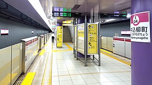
Ushigome-yanagichō Station (牛込柳町駅, Ushigome-yanagichō-eki) is a subway station on the Toei Oedo Line in Shinjuku, Tokyo, Japan, operated by the Tokyo subway operator Tokyo Metropolitan Bureau of Transportation (Toei). It is numbered "E-04".

Ushigome
Neighborhood in Tokyo
Distance: Approx. 825 meters
Latitude and longitude: 35.70183056,139.73613333
Ushigome (牛込) is a neighborhood in Shinjuku, Tokyo, and a former ward (牛込区 Ushigome-ku) in the now-defunct Tokyo City. The name Ushigome refers to a former cattle ranch in the area that was next to a horse ranch, Komagome (駒込). In 1947, when the 35 wards of Tokyo were reorganized into 23, it was merged with Yotsuya ward of Tokyo City and Yodobashi suburban ward of Tokyo-fu to form the modern Shinjuku ward.
Tokyo Chinese School
School
Distance: Approx. 810 meters
Latitude and longitude: 35.6885027,139.7323358
Tokyo Chinese School (TCS) is a Chinese International school in Gobanchō (五番町), Chiyoda, Tokyo, Japan. The Ministry of Education, Culture, Sports, Science and Technology (MEXT) accredits the school. Originally established in 1929 as an elementary school for Overseas Taiwanese, its operation now follows the education system of the Republic of China (Taiwan), and provides education for students ageing between 7 and 18.

Akebonobashi Station
Metro station in Tokyo, Japan
Distance: Approx. 830 meters
Latitude and longitude: 35.69238889,139.72277778
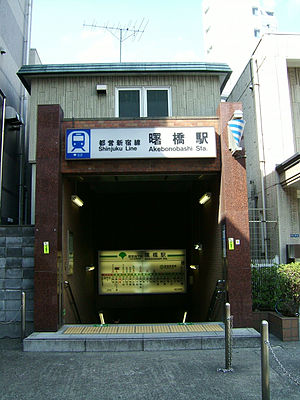
Akebonobashi Station (曙橋駅, Akebonobashi-eki) is a subway station on the Toei Shinjuku Line in Shinjuku, Tokyo, Japan, operated by Toei Subway. Its station number is S-03.
Tokyo Korean School
International school in Japan
Distance: Approx. 869 meters
Latitude and longitude: 35.6969,139.7215
Tokyo Korean School (Japanese: 東京韓国学校 Tōkyō Kankoku Gakkō, Korean: 동경한국학교, romanized: Donggyeong Hanguk Hakgyo) is a Korean school located in Wakamatsu-cho, Shinjuku-ku, Tokyo, Japan; catering to the Korean expatriate community and to Japanese-Koreans living in and around Tokyo. It was founded in 1954. It is affiliated with the South Korean government and Mindan (민단).

JICA Research Institute
Distance: Approx. 145 meters
Latitude and longitude: 35.69442,139.73127
The JICA Research Institute (JICA-RI) (JICA研究所 Jaika Kenkyujo) is a research organization based in Tokyo, Japan. JICA-RI was established as a research wing of the Japan International Cooperation Agency (JICA) on October 1, 2008. In the University of Pennsylvania's 2014 Global Go To Think Tanks Report, JICA-RI is ranked at the highest in the category of international development among institutions in Japan, which is followed by other institutions such as Institute of Developing Economies, JETRO (IDE-JETRO), Japan Institute of International Affairs (JIIA), and Global Industrial and Social Progress Research Institute (GISPRI).

Gobanchō, Chiyoda, Tokyo
District in Tokyo, Japan
Distance: Approx. 731 meters
Latitude and longitude: 35.69017222,139.73536389
Part of the Banchō area, Gobanchō (五番町) is an upscale, mostly residential district of Chiyoda, Tokyo, Japan. As of June 2020, the population of this district is 971 in 439 households.
Weather in this IP's area
broken clouds
19 Celsius
19 Celsius
18 Celsius
20 Celsius
1021 hPa
61 %
1021 hPa
1017 hPa
10000 meters
5.66 m/s
350 degree
75 %
06:17:58
16:33:58

