Country:
 Chinese mainland
Region:
City:
Latitude and Longitude:
Time Zone:
Postal Code:
IP information under different IP Channel
ip-api
Country
Region
City
ASN
Time Zone
ISP
Blacklist
Proxy
Latitude
Longitude
Postal
Route
IPinfo
Country
Region
City
ASN
Time Zone
ISP
Blacklist
Proxy
Latitude
Longitude
Postal
Route
MaxMind
Country
Region
City
ASN
Time Zone
ISP
Blacklist
Proxy
Latitude
Longitude
Postal
Route
Luminati
Country
CNASN
Time Zone
Asia/Shanghai
ISP
CHINA UNICOM China169 Backbone
Latitude
Longitude
Postal
db-ip
Country
Region
City
ASN
Time Zone
ISP
Blacklist
Proxy
Latitude
Longitude
Postal
Route
ipdata
Country
Region
City
ASN
Time Zone
ISP
Blacklist
Proxy
Latitude
Longitude
Postal
Route
Popular places and events near this IP address

Changsha
Capital of Hunan, China
Distance: Approx. 22 meters
Latitude and longitude: 28.228,112.939
Changsha is the capital of Hunan, China. It is the 17th most populous city in China with a population of over 10 million, and the third-most populous city in Central China, located in the lower reaches of the Xiang River in northeastern Hunan. The city forms a part of the Greater Changsha Metropolitan Region along with Zhuzhou and Xiangtan, also known as Changzhutan City Cluster.
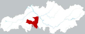
Yuelu, Changsha
District in Hunan, China
Distance: Approx. 1091 meters
Latitude and longitude: 28.2352946,112.93133153
Yuelu District (simplified Chinese: 岳麓区; traditional Chinese: 嶽麓區; pinyin: Yuèlù qū) is one of six urban districts of the prefecture-level city of Changsha, the capital of Hunan Province, China. It is the 4th most populous district (after Heshan, Dingcheng and Yueyanglou Districts) in Hunan. The district is bordered to the north by Wangcheng District, to the west by Ningxiang County, to the south by Yuhu District of Xiangtan City, across the Xiang river to the west by Tianxin, Furong and Kaifu Districts.

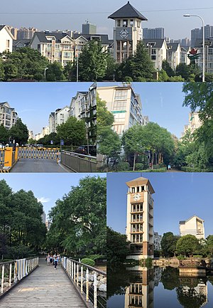
Hunan University of Technology and Business
Public university in Changsha, China
Distance: Approx. 1919 meters
Latitude and longitude: 28.22697,112.919483
The Hunan University of Technology and Business (HUTB, Chinese: 湖南工商大学) is a provincial public university located in Changsha, Hunan, China. As of 2023, Hunan University of Technology and Business ranked the best in Hunan and 23rd nationwide among universities specialized in finance, business, and economics in the recent edition of the recognized Best Chinese Universities Ranking.

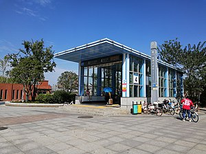
Jinxing Road station
Metro station in Changsha, China
Distance: Approx. 1826 meters
Latitude and longitude: 28.212124,112.935279
Jinxing Road station is a subway station in Changsha, Hunan, China, operated by the Changsha subway operator Changsha Metro.
Xihu Park station
Metro station in Changsha, China
Distance: Approx. 2292 meters
Latitude and longitude: 28.208728,112.946581
Xihu Park station is a subway station in Changsha, Hunan, China, operated by the Changsha subway operator Changsha Metro.
Wangyue Subdistrict
Subdistrict in Hunan, People's Republic of China
Distance: Approx. 1639 meters
Latitude and longitude: 28.23069504,112.92253016
Wangyue Subdistrict (Chinese: 望岳街道; pinyin: Wàngyuè Jiēdào) is an urban subdistrict and the seat of Yuelu District in Changsha, Hunan Province, China. The subdistrict is located in the north eastern part of the district, it is bordered to the north by Yueliangdao Subdistrict of Wangcheng District, to the east by Guanshaling Subdistrict, to the south by Meixihu, Lugu and Yinpenling Subdistricts, to the west by Wangchengpo Subdistrict. Wangyue covers 13.6 km2 (5.3 sq mi) with a population of 27,812 (as of 2010 census), it is divided into four communities and four communities under its jurisdiction, its administrative centre is at Qiliying Community (七里营社区).
Guanshaling
Subdistrict in Changsha, Hunan, China
Distance: Approx. 1359 meters
Latitude and longitude: 28.23246819,112.9519846
Guanshaling Subdistrict (simplified Chinese: 观沙岭街道; traditional Chinese: 觀沙嶺街道; pinyin: Guānshālǐng Jiēdào) is a subdistrict of Yuelu District in Changsha, Hunan, China. The subdistrict has an area of about 14.17 km2 (5.47 sq mi) with a population of 51,324 (as of 2010 census). The subdistrict of Guanshaling has three villages and 13 communities under its jurisdiction, its administrative office is at Juzhou Xinyuan Community (桔洲新苑社区).
Bafang Community
Community in Hunan, People's Republic of China
Distance: Approx. 1150 meters
Latitude and longitude: 28.23824422,112.94176159
Bafang Community (Chinese: 八方社区; pinyin: Bāfāng Shèqū) is a community of Wangyue Subdistrict in Yuelu District, Changsha, China. The community is located in the northeast of Wangyue Subdistrict and the east of Yuelu District, it is a pure residence with 4 blocks of residential area named Bafang Residential Area (Chinese: 八方小区) surrounded by four roads. The residential area of Bafang was named after Bafang Mountain (Chinese: 八方山), it was invested and developed by Changsha Jingfa Real Estate (Chinese: 长沙经发房地产) under Chanfine Group (Chinese: 长房集团).
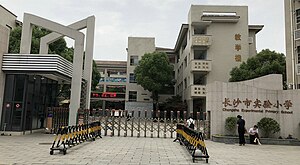
Changsha Experimental Primary School
Public primary school in China
Distance: Approx. 933 meters
Latitude and longitude: 28.23529738,112.94406568
Changsha Experimental Primary School (Chinese: 长沙市实验小学; pinyin: Chǎngshāshì Shíyàn Xiǎoxué) is a six - year public primary school located in Wangyue Subdistrict, Changsha, Hunan. It was formerly known as the First Elementary School of Hunan Province (湖南官立初等第一小学堂) founded in 1905 (31st year of Qing dynasty Guangxu). In December 1983, it was approved to change to the present name by the Changsha Municipal Government.
Guanshaling station
Metro station in Changsha, China
Distance: Approx. 1883 meters
Latitude and longitude: 28.236216,112.955906
Guanshaling station (simplified Chinese: 观沙岭站; traditional Chinese: 觀沙嶺站; pinyin: Guānshālǐng Zhàn) is an interchange station for Changsha Metro Line 4 and Changsha–Zhuzhou–Xiangtan intercity railway.

Liugoulong station
Metro station in Changsha, China
Distance: Approx. 1054 meters
Latitude and longitude: 28.224369,112.948829
Liugoulong station (simplified Chinese: 六沟垅站; traditional Chinese: 六溝垅站; pinyin: Liùgōulǒng Zhàn) is a subway interchange station in Changsha, Hunan, China, operated by the Changsha subway operator Changsha Metro.

Changsha Municipal People's Government
Distance: Approx. 934 meters
Latitude and longitude: 28.234451,112.945358
The Changsha Municipal People's Government (simplified Chinese: 长沙市政府; traditional Chinese: 長沙市政府; pinyin: Chángshāshì Zhèngfǔ) is the top-tier local government administrative body of the People's Republic of China that governs the prefecture-level city of Changsha, the capital of Hunan province. The current mayor is Zheng Jianxin.
Weather in this IP's area
broken clouds
27 Celsius
30 Celsius
27 Celsius
27 Celsius
1008 hPa
79 %
1008 hPa
1000 hPa
10000 meters
5.72 m/s
9.53 m/s
341 degree
51 %
06:15:15
18:28:58