Country:
Region:
City:
Latitude and Longitude:
Time Zone:
Postal Code:
IP information under different IP Channel
ip-api
Country
Region
City
ASN
Time Zone
ISP
Blacklist
Proxy
Latitude
Longitude
Postal
Route
Luminati
Country
ASN
Time Zone
Asia/Tokyo
ISP
Cable Television TOYAMA Inc.
Latitude
Longitude
Postal
IPinfo
Country
Region
City
ASN
Time Zone
ISP
Blacklist
Proxy
Latitude
Longitude
Postal
Route
db-ip
Country
Region
City
ASN
Time Zone
ISP
Blacklist
Proxy
Latitude
Longitude
Postal
Route
ipdata
Country
Region
City
ASN
Time Zone
ISP
Blacklist
Proxy
Latitude
Longitude
Postal
Route
Popular places and events near this IP address

Toyama (city)
Core city in Chūbu, Japan
Distance: Approx. 315 meters
Latitude and longitude: 36.69591667,137.21369444
Toyama (富山市, Toyama-shi, Japanese: [toꜜjama]) is the capital city of Toyama Prefecture, Japan, located on the coast of the Sea of Japan in the Chūbu region on central Honshū, about 200 km (120 mi) north of the city of Nagoya and 300 km (190 mi) northwest of Tokyo. As of 1 June 2019, the city had an estimated population of 415,844 in 176,643 households, and a population density of 335 persons per km2. Its total area was 1,241.77 square kilometres (479.45 sq mi).

Toyama City Gymnasium
Distance: Approx. 1100 meters
Latitude and longitude: 36.706572,137.214481
Toyama City Gymnasium is an indoor sporting arena located in Toyama, Japan. The capacity of the arena is 5,000 people. It hosted some of the group games for the 2003 FIVB Volleyball Men's World Cup.
Siege of Toyama
Distance: Approx. 669 meters
Latitude and longitude: 36.6933,137.211
The siege of Toyama was a battle during the Azuchi-Momoyama period (16th century) of Japan.

Toyama Station
Major railway station in Toyama, Toyama Prefecture, Japan
Distance: Approx. 588 meters
Latitude and longitude: 36.701217,137.213209
Toyama Station (富山駅, Toyama-eki) is a major railway station in Toyama, Toyama Prefecture, Japan, operated by West Japan Railway Company (JR West) and Ainokaze Toyama Railway. It is the largest and busiest railway terminal in Toyama. Dentetsu Toyama Station (電鉄富山駅, Dentetsu-Toyama-eki), the local railway terminal that provides access to nearby towns (Funahashi, Kamiichi, Tateyama, etc.) as well as access to Tateyama Station (the starting point of the Tateyama Kurobe Alpine Route) via Toyama Chihō Railway is next to Toyama Station.

Inarimachi Station (Toyama)
Railway station in Toyama, Toyama Prefecture, Japan
Distance: Approx. 1303 meters
Latitude and longitude: 36.6968,137.2316
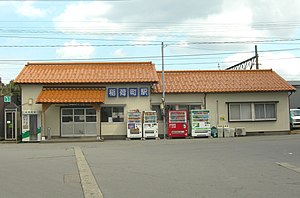
Inarimachi Station (稲荷町駅, Inarimachi-eki) is a train station in the city of Toyama, Toyama Prefecture, Japan operated by the Toyama Chihō Railway.
Fujikoshi Station
Railway station in Toyama, Toyama Prefecture, Japan
Distance: Approx. 1715 meters
Latitude and longitude: 36.6879,137.2326
Fujikoshi Station (不二越駅, Fujikoshi-eki) is a railway station in the city of Toyama, Toyama Prefecture, Japan, operated by the private railway operator Toyama Chihō Railway.

Toyama Castle
Building in Toyama Prefecture, Japan
Distance: Approx. 669 meters
Latitude and longitude: 36.6933,137.211
Toyama Castle (富山城, Toyama-jō) is a flatland-style Japanese castle located in the city of Toyama, Toyama Prefecture, in the Hokuriku region of Japan. It is also called Azumi Castle (安住城 Azumi-jō). Built in 1543, the castle and its surrounding land is maintained by the government of Japan as a public park.
Tower 111
Skyscraper in Japan
Distance: Approx. 721 meters
Latitude and longitude: 36.70333333,137.21611111
The Tower 111 (タワー111, Tawā Toripuruwan) is a skyscraper in Toyama City, Japan. Construction of the 111 m (364 ft), 22-storey building was finished in 1994. As of 2011, the building was the tallest structure in Toyama Prefecture.

Ainokaze Toyama Railway
Third-sector railway operating company in Japan
Distance: Approx. 722 meters
Latitude and longitude: 36.70258333,137.21311111
The Ainokaze Toyama Railway (あいの風とやま鉄道株式会社, Ainokaze Toyama Tetsudō Kabushiki-gaisha) is a Japanese third-sector railway operating company established in 2012 to operate passenger railway services on the section of the JR West Hokuriku Main Line within Toyama Prefecture when it was separated from the JR West network in March 2015, coinciding with the opening of the Hokuriku Shinkansen extension from Nagano to Kanazawa. The company was founded on 24 July 2012, and has its headquarters in Toyama in Toyama Prefecture.

Sakaemachi Station (Toyama)
Railway station in Toyama, Toyama Prefecture, Japan
Distance: Approx. 1582 meters
Latitude and longitude: 36.69138889,137.23333333
Sakaemachi Station (栄町駅, Sakaemachi-eki) is a railway station in the city of Toyama, Toyama Prefecture, Japan, operated by the private railway operator Toyama Chihō Railway.
Toyama Science Museum
Building in Toyama Prefecture, Japan
Distance: Approx. 1832 meters
Latitude and longitude: 36.680983,137.211804
Toyama Science Museum (富山市科学博物館, Toyama-shi Kagaku Hakubutsukan) first opened in Toyama, Toyama Prefecture, Japan in 1979 as the Toyama City Science and Culture Center (富山市科学文化センター). The Museum reopened in its current guise after renewal in 2007. The museum collects, preserves, researches, and displays materials relating to the natural history of the area and there is also a planetarium.

Toyama Gokoku Shrine
Shrine in Toyama, Japan
Distance: Approx. 1628 meters
Latitude and longitude: 36.68972222,137.20111111
Toyama Gokoku Shrine (富山縣護國神社, Toyamaken gokoku jinja) is a Shinto shrine located in Toyama, Toyama Prefecture, Japan. It enshrines the kami of "martyrs of the state" (国事殉難者) or soldiers whom have perished and its annual festivals take place on April 25 and October 5. It was established in 1913.
Weather in this IP's area
broken clouds
15 Celsius
15 Celsius
13 Celsius
16 Celsius
1019 hPa
94 %
1019 hPa
1018 hPa
10000 meters
0.51 m/s
75 %
06:30:07
16:41:55


