Country:
 Bangladesh
Region:
City:
Latitude and Longitude:
Time Zone:
Postal Code:
IP information under different IP Channel
ip-api
Country
Region
City
ASN
Time Zone
ISP
Blacklist
Proxy
Latitude
Longitude
Postal
Route
IPinfo
Country
Region
City
ASN
Time Zone
ISP
Blacklist
Proxy
Latitude
Longitude
Postal
Route
MaxMind
Country
Region
City
ASN
Time Zone
ISP
Blacklist
Proxy
Latitude
Longitude
Postal
Route
Luminati
Country
BDASN
Time Zone
Asia/Dhaka
ISP
Tomato Web Pvt Limited
Latitude
Longitude
Postal
db-ip
Country
Region
City
ASN
Time Zone
ISP
Blacklist
Proxy
Latitude
Longitude
Postal
Route
ipdata
Country
Region
City
ASN
Time Zone
ISP
Blacklist
Proxy
Latitude
Longitude
Postal
Route
Popular places and events near this IP address

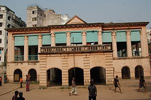
Ahsan Manzil
National museum in Bangladesh
Distance: Approx. 243 meters
Latitude and longitude: 23.70859722,90.40605833
Ahsan Manzil is a palace located in the Kumartoli area of Dhaka, Bangladesh. It was formerly the residence and seat of the Nawab of Dhaka and has been designated an Old Dhaka Heritage Site. It now serves as a museum.
Dhaka Collegiate School
Government, boys high school in Dhaka, Bangladesh
Distance: Approx. 453 meters
Latitude and longitude: 23.707728,90.410757
Dhaka Collegiate School is a secondary school in Dhaka, Bangladesh. It is one of the oldest schools in Bangladesh. The students of collegiate school are called Collegiatian.
Pogose School
Private school in Bangladesh
Distance: Approx. 306 meters
Latitude and longitude: 23.7094,90.4102
Pogose Laboratory School and College, IER, Jagannath University (Bengali: পোগোজ ল্যাবরেটরি স্কুল এন্ড কলেজ ,আ.ই.আর,জগন্নাথ বিশ্ববিদ্যালয়) was established in Dhaka on June 12, 1848, as the first private school of the country by Armenian merchant Nicholas Pogose, who was an ex-student of Dhaka Collegiate School. It is located at Chittaranjan Avenue. The school was managed as a proprietary institution and in 1871, about a year after the death of Pogose, it was taken over by Mohini Mohan Das, a banker and zamindar.

Jagannath University
Public university in Sadarghat, Bangladesh
Distance: Approx. 378 meters
Latitude and longitude: 23.71027778,90.41111111
Jagannath University (JnU) (Bengali: জগন্নাথ বিশ্ববিদ্যালয়) is a public university located in Sadarghat, Dhaka, the capital of Bangladesh. Founded as Dhaka Brahma School in 1858 and renamed Jagannath School in 1872, the institution was taken over by the Pakistani government in 1968, while Bangladesh was still a part of Pakistan. It opened graduate and post-graduate programmes in 1975 and was approved as a full public university in 2005.
Kotwali Thana (Dhaka)
Thana in Dhaka South City Corporation, Bangladesh
Distance: Approx. 166 meters
Latitude and longitude: 23.71069,90.409
Dhaka Kotwali (Bengali: ঢাকা কোতোয়ালী) is the Sadar (Principal) Thana of Dhaka District in the Division of Dhaka, Bangladesh.

Dhaka National Medical College
Private medical college located in Dhaka, Bangladesh
Distance: Approx. 490 meters
Latitude and longitude: 23.7107,90.4122
Dhaka National Medical College is a private medical college in Dhaka, Bangladesh. It was founded in 1925 as the Dhaka National Medical Institute which was then situated near Bahadur Shah Park. Following the 1972 independence of Bangladesh, the educational function of the Dhaka National Medical Institute became moribund, although the associated hospital remained active.

Old Dhaka
Historical territory of the city of Dhaka
Distance: Approx. 437 meters
Latitude and longitude: 23.70694444,90.40944444
Old Dhaka (Bengali: পুরান ঢাকা, romanized: Puran Dhaka) is a term used to refer to the historic old city of Dhaka, the capital of Bangladesh. It was founded in 1608 as Jahangirabad or Jahangirnagar (Bengali: জাহাঙ্গীরনগর, romanized: Jahangirnogor, lit. 'City of Jahangir'), the capital of Mughal Province of Bengal and named after the Mughal emperor Jahangir. It is located on the banks of the Buriganga River.

Shankhari Bazaar
Neighborhoods in Dhaka in Dhaka Division, Bangladesh
Distance: Approx. 237 meters
Latitude and longitude: 23.709995,90.409683
Shankhari Bazaar is one of the oldest areas in Old Dhaka broadly known as Shankhari Potti. It stretches along a narrow lane, lined with richly decorated brick buildings, built during the late Mughal or Colonial period.

Gol Talab
Distance: Approx. 256 meters
Latitude and longitude: 23.70972222,90.405
Gol Talab or Gol Talaab (talab means tank) also known as Nawab Bari Pukur, is a small oval-shaped water tank/pond in Islampur, Old Dhaka, Dhaka, Bangladesh, located immediately to the north-west of the Ahsan Manzil Palace and north of the Buriganga River. Gol Talab is an official heritage site, designated by the city government of Dhaka.
Shankharibazar massacre
Distance: Approx. 239 meters
Latitude and longitude: 23.71,90.4097
Shankharibazar massacre (Bengali: শাঁখারীবাজার গণহত্যা) was a massacre of over 212 Bengali Hindus in the Shankharibazar area of Old Dhaka in East Pakistan on 26 March 1971 by the Pakistani occupation army. The survivors fled to the villages on the other side of the Buriganga, in the region now known as Keraniganj. Shankharibazar became deserted and dead bodies remained on the streets for quite a long time.

St Thomas Church, Dhaka
Church in Dhaka, Bangladesh
Distance: Approx. 490 meters
Latitude and longitude: 23.7102,90.4122
St Thomas Cathedral Church is a cathedral belonging to the Diocese of Dhaka of the Church of Bangladesh, which is a United Protestant denomination that formed as a result of a merger between the Anglican and Presbyterian churches in the region. It is the seat of the diocese. The church premise was in an area of lush greeneries with the famous Bahadur Shah Park at a stone's throw distance on the south.

Azad (movie theater)
Movie theater in Bangladesh
Distance: Approx. 248 meters
Latitude and longitude: 23.7112883,90.4096266
Azad is a movie theater located in Johnson Road, Dhaka, Bangladesh. Azad is one of the oldest movie theaters and the fourth oldest movie theater in the capital of the country.
Weather in this IP's area
haze
30 Celsius
36 Celsius
30 Celsius
30 Celsius
1008 hPa
74 %
1008 hPa
1007 hPa
4000 meters
1.54 m/s
110 degree
40 %
05:57:18
17:29:00