Country:
 Pakistan
Region:
City:
Latitude and Longitude:
Time Zone:
Postal Code:
IP information under different IP Channel
ip-api
Country
Region
City
ASN
Time Zone
ISP
Blacklist
Proxy
Latitude
Longitude
Postal
Route
Luminati
Country
PKASN
Time Zone
Asia/Karachi
ISP
Multinet Pakistan Pvt. Ltd.
Latitude
Longitude
Postal
IPinfo
Country
Region
City
ASN
Time Zone
ISP
Blacklist
Proxy
Latitude
Longitude
Postal
Route
db-ip
Country
Region
City
ASN
Time Zone
ISP
Blacklist
Proxy
Latitude
Longitude
Postal
Route
ipdata
Country
Region
City
ASN
Time Zone
ISP
Blacklist
Proxy
Latitude
Longitude
Postal
Route
Popular places and events near this IP address
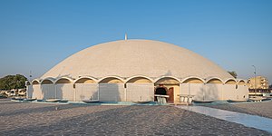
Masjid-e-Tooba
Mosque in Karachi, Pakistan
Distance: Approx. 1817 meters
Latitude and longitude: 24.84301667,67.05445
Masjid-e-Tooba or Tooba Mosque (Urdu: مسجد طوبٰی) also known as Gol Masjid, is located in the city of Karachi, Sindh the province of Pakistan. It is situated in the phase 2 of DHA (Defence Housing Authority), Karachi. The construction of the mosque began in 1966 and completed in 1969.
Azam Basti
Residential neighborhood of Karachi, Pakistan
Distance: Approx. 2126 meters
Latitude and longitude: 24.85,67.06666667
Azam Basti (Urdu: اعظم بستی) is a neighborhood in Karachi East district of Karachi, Pakistan. It was previously administered as part of Jamshed Town, which was disbanded in 2011. There are several ethnic groups in Azam Basti including Muhajirs, Punjabis, Sindhis, Kashmiris, Seraikis, Pakhtuns, Balochis, Memons, Bohras, Ismailis.
Chanesar Town
Neighbourhood in Karachi, Karachi East
Distance: Approx. 2702 meters
Latitude and longitude: 24.85,67.05
Chanesar Town (Urdu: چنیسر گوٹھ) is a neighborhood in Karachi East district of Karachi, Pakistan. It is led by The Pakistan Peoples Party by Chairman Mohammad Asif B and Saeed Ghani, and all of the Sindh Province. It was previously administered as part of Jamshed Town, which was disbanded in 2011.

PNS Shifa Hospital
Pakistan Navy's military hospital for medical training and certification.
Distance: Approx. 1788 meters
Latitude and longitude: 24.837087,67.050172
The Pakistan Navy Station Shifa (reporting name:PNS Shifa) is a military hospital located in the Clifton Cantonment in Karachi, Sindh, Pakistan.
Gizri
Area of Karachi in Sindh, Pakistan
Distance: Approx. 2291 meters
Latitude and longitude: 24.817413,67.049367
Gizri is one of the neighborhoods of Clifton Cantonment in the city of Karachi, Sindh, Pakistan. One of the oldest neighborhoods of Karachi was considered as Fishermen Village. There's still a small number of fisher live here who speak Bravhi & Sindhi language.
DHA Suffa University
University in Sindh, Pakistan
Distance: Approx. 2237 meters
Latitude and longitude: 24.8147,67.0796
DHA Suffa University (DSU) (Urdu: ڈی ایچ اے جامعة الصفّہ) is a non-profit private sector university named after Suffah of Masjid-e-Nabwi. It is located in the Phase VII (extension) of Defence Housing Authority, Karachi, in Sindh, Pakistan. The university received its Charter in 2002 and started operations in 2012.
Heritage Foundation Pakistan
Distance: Approx. 1796 meters
Latitude and longitude: 24.8230817,67.0509557
Heritage Foundation of Pakistan is a Pakistani heritage and humanitarian aid organization founded by Yasmeen Lari and Suhail Zaheer Lari in 1980. In 1984, when there were plans to demolish the historically significant Hindu Gymkhana, Karachi building because it had somewhat deteriorated due to lack of maintenance, Heritage Foundation Pakistan intervened to save it. After that, the building was designated as a Protected Sindh Cultural Heritage building and is still being used as a facility that houses the National Academy of Performing Arts .
Baltistani Society
Distance: Approx. 2702 meters
Latitude and longitude: 24.85,67.05
Baltistani Society is one of the neighbourhoods of Jamshed Town in Karachi, Sindh, Pakistan. There are several ethnic groups including Baltis, Muhajirs, Punjabis, Sindhis, Kashmiris, Seraikis, Pakhtuns, Balochis, Memons, Bohras Ismailis and Christians.
Abyssinia Lines
Place in Karachi, Sindh, Pakistan
Distance: Approx. 2702 meters
Latitude and longitude: 24.85,67.05
Abyssinia Lines is one of the neighbourhoods of Jamshed Town in Karachi, Sindh, Pakistan. There are several ethnic groups including Muhajirs, Punjabis, Sindhis, Kashmiris, Seraikis, Pakhtuns, Balochis, Memons, Bohras Ismailis, Baltis Nagaris commonly call Gilgitis and Christians. It is established as a refugee Colony for muhajirs.
Gulistan-e-Zafar
Neighborhood in Karachi
Distance: Approx. 2702 meters
Latitude and longitude: 24.85,67.05
Gulistan-e-Zafar is one of the neighbourhoods of Jamshed Town in Karachi, Sindh, Pakistan. There are several ethnic groups including Muhajirs, Punjabis, Sindhis, Kashmiris, Seraikis, Pakhtuns, Balochis, Memons, Bohras Ismailis and Christians.
Delhi Colony
Neighbourhood in Karachi, Pakistan
Distance: Approx. 1689 meters
Latitude and longitude: 24.83333333,67.05
Delhi Colony (Urdu: دہلی کالونی) is a neighbourhood near Clifton, Karachi.

Consulate-General of the United Arab Emirates, Karachi
Diplomatic mission located in Pakistan
Distance: Approx. 2496 meters
Latitude and longitude: 24.81527778,67.04877778
The Consulate-General of the United Arab Emirates in Karachi is a diplomatic mission of the UAE in Pakistan.
Weather in this IP's area
smoke
26 Celsius
26 Celsius
26 Celsius
26 Celsius
1013 hPa
89 %
1013 hPa
1012 hPa
5000 meters
2.06 m/s
250 degree
06:39:34
17:50:55