Country:
Region:
City:
Latitude and Longitude:
Time Zone:
Postal Code:
IP information under different IP Channel
ip-api
Country
Region
City
ASN
Time Zone
ISP
Blacklist
Proxy
Latitude
Longitude
Postal
Route
Luminati
Country
ASN
Time Zone
Asia/Shanghai
ISP
China Education and Research Network Center
Latitude
Longitude
Postal
IPinfo
Country
Region
City
ASN
Time Zone
ISP
Blacklist
Proxy
Latitude
Longitude
Postal
Route
db-ip
Country
Region
City
ASN
Time Zone
ISP
Blacklist
Proxy
Latitude
Longitude
Postal
Route
ipdata
Country
Region
City
ASN
Time Zone
ISP
Blacklist
Proxy
Latitude
Longitude
Postal
Route
Popular places and events near this IP address

Shanghai
Municipality of China
Distance: Approx. 322 meters
Latitude and longitude: 31.22861111,121.47472222
Shanghai is a direct-administered municipality and the most populous urban area in China. The city is located on the Chinese shoreline on the southern estuary of the Yangtze River, with the Huangpu River flowing through it. The population of the city proper is the third largest in the world, with around 24.87 million inhabitants in 2023, while the urban area is the most populous in China, with 29.87 million residents.
People's Square
Public square in central Shanghai
Distance: Approx. 373 meters
Latitude and longitude: 31.229564,121.47438
People's Square (Chinese: 人民广场) is a large public square in the Huangpu District of Shanghai. It is south of Nanjing Road (West) and north of Huaihai Road (East). People's Square is the site of Shanghai's municipal government headquarters building and the standard reference point for measurement of distance of almost all highways in the Shanghai municipality is set in the north of the square, near the fountain.

Site of the First CPC National Congress · South Huangpi Road station
Shanghai Metro station
Distance: Approx. 479 meters
Latitude and longitude: 31.222745,121.473306
Site of the First CPC National Congress · South Huangpi Road (simplified Chinese: 一大会址·黄陂南路; traditional Chinese: 一大會址·黃陂南路; pinyin: Yīdà Huìzhǐ Huángpí Nán Lù) is an interchange station on lines 1 and 14 of the Shanghai Metro; line 1 opened on 10 April 1995 as part of the section between Jinjiang Park and Shanghai Railway Station; It became an interchange station on 31 December 2021 with the opening of line 14. On 20 June 2021, to celebrate the 100th Anniversary of the Chinese Communist Party, the station name changed from South Huangpi Road Station to Site of the First CPC National Congress · South Huangpi Road Station. Nearby Xintiandi station was also renamed to Site of the First CPC National Congress · Xintiandi station.
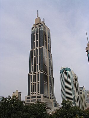
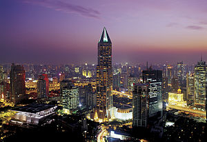
Lippo Plaza
Office & Retail in Shanghai, China
Distance: Approx. 117 meters
Latitude and longitude: 31.226294,121.470992
Lippo Plaza is a 38 floor tower in the Luwan District of Shanghai, China and was completed in 1998. It was built by architect Frank C Y Feng and Associates Limited.

K11 (Shanghai)
Office and retail complex in Shanghai, China
Distance: Approx. 368 meters
Latitude and longitude: 31.2255,121.4685
K11 (Chinese: K11购物艺术中心; pinyin: K11 Gòuwù Yìshù Zhōngxīn, also known as K11 Art Mall) is a shopping mall, located on Huaihai Lu of the Xintiandi district, in the former Luwan District of Shanghai, China. It is 278 m high and was designed by Bregman and Hamann Architects. The mall consists of six stories above ground, and three underground, with a total area of about 40,000 m2.

Dashijie station
Shanghai Metro station
Distance: Approx. 294 meters
Latitude and longitude: 31.2294,121.473
Dashijie (Chinese: 大世界; pinyin: Dàshìjiè; lit. 'Great World') is a station on Shanghai Metro Line 8 and Line 14. It began operation on 29 December 2007 and became an interchange station with Line 14 on 30 December 2021.

JW Marriott Shanghai
Distance: Approx. 482 meters
Latitude and longitude: 31.2308,121.4698
The JW Marriott Hotel Shanghai is a flagship hotel of the Marriott Group in Shanghai, China, that opened in 2003. It is housed at Tomorrow Square, the tallest building in downtown Puxi. Tomorrow Square was designed by Richards Mixon of John Portman & Associates.

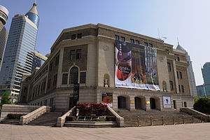
Shanghai Concert Hall
Concert hall in Shanghai, China
Distance: Approx. 239 meters
Latitude and longitude: 31.22890556,121.47288889
Cadillac·Shanghai Concert Hall is located on the intersection of Yan'an Road and South Tibet Road of Huangpu District, Shanghai. It was founded in 1930 as Nanking Theatre. In 1949, its name was changed to Beijing Cinema.
Shanghai Race Club
Horse racing club in Shanghai, China
Distance: Approx. 358 meters
Latitude and longitude: 31.23,121.473
The Shanghai Race Club was a horse racing club located in Shanghai, China. The club was based at the Shanghai Racecourse (跑马厅; 跑馬廳), and the two names are often used interchangeably. Originally the Race Committee of the International Recreation Club, the Race Club was first established in 1850, with the building of Shanghai's first racecourse.

Great World
Historic amusement arcade in Shanghai, China
Distance: Approx. 454 meters
Latitude and longitude: 31.2302,121.4748
The Great World (Chinese: 大世界; pinyin: Dà Shìjìe; Shanghainese: Da Syga) is an amusement arcade and entertainment complex located in Shanghai, China. Built in 1917 on the corner of Avenue Edward VII (now Yan'an Road) and Yu Ya Ching Road (now Middle Xizang Road), it was the first and for a long time the most influential indoor amusement arcade in Shanghai, so much so that it spawned imitations all over China. It had gained a reputation as the “No.

Greater Shanghai Plan
1927 Plan for Shanghai developed by the Republic of China
Distance: Approx. 453 meters
Latitude and longitude: 31.2307,121.4737
The Greater Shanghai Plan (simplified Chinese: 大上海计划; traditional Chinese: 大上海計劃; pinyin: Dà Shànghǎi Jìhuà) was a 1927 plan for the city of Shanghai, China, drawn up by the Nationalist Government of the Republic of China in Nanjing. It was presented at the 123rd meeting of the Shanghai City Government in July 1929 and as one of its provisions allocated 7,000 mu (~4.6 km2) in the modern day Jiangwan Subdistrict of Shanghai's Yangpu District for the construction of a government headquarters and administration centre. Had it been completed, the government headquarters building would have stood close to the junction of today's Hengren Road (恒仁路) and the Qingyuan Ring Road (清源环路) (31.3131°N 121.5255°E / 31.3131; 121.5255).

Bloody Saturday (Shanghai)
Misdirected attack on civilians during the Second Sino-Japanese War
Distance: Approx. 451 meters
Latitude and longitude: 31.230628,121.473848
Bloody Saturday, also known as Black Saturday and the Great World bombing, was a misdirected attack on civilians by the Republic of China Air Force on 14 August 1937 during the Battle of Shanghai of the Second Sino-Japanese War. On the day, the Chinese Air Force, in an unsuccessful attempt to attack the Japanese cruiser Idzumo moored next to the Japanese Consulate in Shanghai, accidentally bombed the city centre, resulting in the deaths of some thousand civilians.
Weather in this IP's area
mist
21 Celsius
21 Celsius
21 Celsius
21 Celsius
1016 hPa
94 %
1016 hPa
1013 hPa
4000 meters
2 m/s
30 degree
40 %
06:21:28
16:56:09

