103.31.105.131 - IP Lookup: Free IP Address Lookup, Postal Code Lookup, IP Location Lookup, IP ASN, Public IP
Country:
Region:
City:
Location:
Time Zone:
Postal Code:
IP information under different IP Channel
ip-api
Country
Region
City
ASN
Time Zone
ISP
Blacklist
Proxy
Latitude
Longitude
Postal
Route
Luminati
Country
Region
pb
City
lahore
ASN
Time Zone
Asia/Karachi
ISP
Cyber Internet Services Pvt Ltd.
Latitude
Longitude
Postal
IPinfo
Country
Region
City
ASN
Time Zone
ISP
Blacklist
Proxy
Latitude
Longitude
Postal
Route
IP2Location
103.31.105.131Country
Region
punjab
City
gujranwala
Time Zone
Asia/Karachi
ISP
Language
User-Agent
Latitude
Longitude
Postal
db-ip
Country
Region
City
ASN
Time Zone
ISP
Blacklist
Proxy
Latitude
Longitude
Postal
Route
ipdata
Country
Region
City
ASN
Time Zone
ISP
Blacklist
Proxy
Latitude
Longitude
Postal
Route
Popular places and events near this IP address

Gujranwala
Metropolis in Punjab
Distance: Approx. 583 meters
Latitude and longitude: 32.15666667,74.19
Gujranwala (Punjabi: گُجرانوالہ, pronounced [gʊˈd͡ʒɾãːʋaːɭaː]; Urdu: گوجرانوالہ, pronounced [ɡoːdʒᵊɾãːʋaːlaː]) is the fourth most-populous city in the Pakistani province of Punjab. Located in northern Punjab's Rachna Doab, it serves as the headquarters of the eponymous district and division. It is also known as "City of Wrestlers" and is quite famous for its food.

Shadman, Karachi
Neighbourhood of Karachi
Distance: Approx. 5133 meters
Latitude and longitude: 32.11666667,74.2
Shadman Town (Urdu: شادمان ) is one of the neighbourhoods of North Nazimabad Town in Karachi, Sindh, Pakistan. It is the Union Council 8 of North Nazimabad Town. Sector 14/A and Sector 14/B comprised this town.
Jinnah Stadium, Gujranwala
Multipurpose stadium in Gujranwala, Punjab, Pakistan
Distance: Approx. 320 meters
Latitude and longitude: 32.16361111,74.19083333
The Jinnah Stadium, formerly known as Municipal Stadium, is a multipurpose stadium in Gujranwala, Punjab, Pakistan. It is used mostly for cricket matches. Built in 1981, the creator of this stadium is Alhaj Muhammad Aslam Butt (former mayor of Gujranwala).
Shaikh Rajada
Village in Punjab, Pakistan
Distance: Approx. 6488 meters
Latitude and longitude: 32.17305556,74.25583333
Shaikh Rajada, also spelled Shaikherjada, is a village on Pasroor Road in Gujranwala District in West Punjab (Pakistan), with a population of around 5000 as of 2021. It is said that the village is named after a person Shaikhu. He has three other brothers named Pandu, Gagard and Azam so the sarounded villages are named after them i.e.
Board of Intermediate and Secondary Education, Gujranwala
Examination board in Gujranwala, Punjab
Distance: Approx. 4509 meters
Latitude and longitude: 32.2022,74.188
The Board of Intermediate and Secondary Education, Gujranwala (colloquially known as BISE Gujranwala) is an examination board for secondary and intermediate education in Gujranwala Division.
Khiali Shahpur
Town in Punjab, Pakistan
Distance: Approx. 4755 meters
Latitude and longitude: 32.121,74.173
Khiali Shahpur is a town in Gujranwala in Punjab, Pakistan.
Islam Medical College
Distance: Approx. 901 meters
Latitude and longitude: 32.15438,74.18423
Islam Medical College (abbreviated as IMC), established in 2010, is a private college of medicine located on Pasroor Road, Sialkot, Punjab, Pakistan. It is registered with Pakistan Medical commission. PMC, affiliated with UHS and approved by Ministry of Health.

University of the Punjab, Gujranwala
Public university in Gujranwala, Pakistan
Distance: Approx. 4607 meters
Latitude and longitude: 32.190336,74.152994
University of the Punjab, Gujranwala Campus (also referred to as Punjab University Gujranwala campus or PUGC) is a satellite campus of University of the Punjab, Lahore which is located in Gujranwala, Punjab, Pakistan. It is the third-oldest campus amongst the five University of the Punjab campuses. The university occupies 81 kanals (approx.
Gujranwala railway station
Railway station in Gujranwala, Pakistan
Distance: Approx. 1668 meters
Latitude and longitude: 32.17666667,74.1875
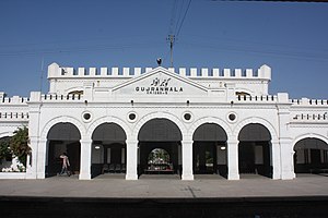
Gujranwala Railway Station (Urdu: گوجرانوالہ ریلوے اسٹیشن) is located in Gujranwala city, Gujranwala district of Punjab province of the Pakistan. Gujranwala is the 5th largest city of Pakistan. Gujranwala Railway Station consists of 4 platforms.
Gujranwala City railway station
Railway station in Gujranwala, Pakistan
Distance: Approx. 1640 meters
Latitude and longitude: 32.1764,74.1871
Gujranwala City Railway Station (Urdu: گوجرانوالہ شہر ریلوے اسٹیشن) was a railway station located at Grand Trunk Road, Gujranwala, Punjab. It is no more functional.

Clock Tower, Gujranwala
Clock tower in Pakistan, Pakistan
Distance: Approx. 824 meters
Latitude and longitude: 32.1587,74.180309
Clock Tower, Gujranwala, also known as Estcourt Clock Tower, is a clock tower in Gujranwala, Punjab, Pakistan.
Ladhe Wala Waraich
Municipal Council in Punjab, Pakistan
Distance: Approx. 6899 meters
Latitude and longitude: 32.157755,74.115244
Ladhe Wala Waraich (Punjabi and Urdu: لدھونوالہ وڑائچ), is a city of Gujranwala District in the Punjab province of Pakistan. The city is part Gujranwala Saddar Tehsil. Ladhe Wala Waraich lies to the west of Gujranwala and is part of the larger metropolitan area.
Weather in this IP's area
broken clouds
10 Celsius
8 Celsius
10 Celsius
10 Celsius
1015 hPa
19 %
1015 hPa
989 hPa
10000 meters
2.27 m/s
2.78 m/s
143 degree
58 %
