Country:
Region:
City:
Latitude and Longitude:
Time Zone:
Postal Code:
IP information under different IP Channel
ip-api
Country
Region
City
ASN
Time Zone
ISP
Blacklist
Proxy
Latitude
Longitude
Postal
Route
Luminati
Country
ASN
Time Zone
Asia/Jakarta
ISP
PT JC Indonesia
Latitude
Longitude
Postal
IPinfo
Country
Region
City
ASN
Time Zone
ISP
Blacklist
Proxy
Latitude
Longitude
Postal
Route
db-ip
Country
Region
City
ASN
Time Zone
ISP
Blacklist
Proxy
Latitude
Longitude
Postal
Route
ipdata
Country
Region
City
ASN
Time Zone
ISP
Blacklist
Proxy
Latitude
Longitude
Postal
Route
Popular places and events near this IP address

Kotagede
Kemantren in Java, Indonesia
Distance: Approx. 709 meters
Latitude and longitude: -7.81786484,110.39541084
Kotagede (Javanese: ꦏꦸꦛꦒꦼꦝꦺ, romanized: Kuthagedhé) is a city district (kemantren) and a historic neighborhood in Yogyakarta, Special Region of Yogyakarta, Indonesia. Kotagede contains the remains of the first capital of Mataram Sultanate, established in the 16th century. Some of the remains of the old Kotagede are remains of the palace, the royal cemetery, the royal mosque, and defensive walls and moats.

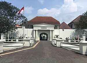
Fort Vredeburg Museum
History museum in Jalan Ahmad Yani No. 6, Yogyakarta
Distance: Approx. 3136 meters
Latitude and longitude: -7.800375,110.366378
Fort Vredeburg Museum (Indonesian: Museum Benteng Vredeburg; Javanese: ꦩꦸꦱꦶꦪꦸꦩ꧀ꦧꦺꦠꦺꦁꦮ꦳ꦽꦢꦼꦧꦸꦂꦒ꧀, romanized: Musiyum Bètèng Vredeburg) was a former colonial fortress located in the city of Yogyakarta, Special Region of Yogyakarta, Indonesia. The military complex—owned by the Yogyakarta Sultanate, but leased to the central government and managed by an agency of the central government—has been converted into a museum of the Indonesian independence struggle which was opened in 1992. It is located in front of Gedung Agung and near the Kraton Yogyakarta (Sultan's Palace).

Yogyakarta
Capital of the Special Region of Yogyakarta, Indonesia
Distance: Approx. 3245 meters
Latitude and longitude: -7.80138889,110.36444444
Yogyakarta (English: YOHG-yə-KAR-tə; Javanese: ꦔꦪꦺꦴꦒꦾꦏꦂꦠ Ngayogyakarta [ŋɑːˈjɔɡjɔˈkɑːrtɔ]; Petjo: Jogjakarta) is the capital city of the Special Region of Yogyakarta in Indonesia, in the south-central part of the island of Java. As the only Indonesian royal city still ruled by a monarchy, Yogyakarta is regarded as an important centre for classical Javanese fine arts and culture such as ballet, batik textiles, drama, literature, music, poetry, silversmithing, visual arts, and wayang puppetry. Renowned as a centre of Indonesian education, Yogyakarta is home to a large student population and dozens of schools and universities, including Gadjah Mada University, the country's largest institute of higher education and one of its most prestigious.

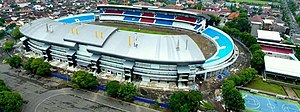
Mandala Krida Stadium
Sporting venue in Yogyakarta, Indonesia
Distance: Approx. 2465 meters
Latitude and longitude: -7.79583333,110.38416667
Mandala Krida Stadium (Indonesian: Stadion Mandala Krida; Javanese: ꦱꦼꦠꦝꦶꦪꦺꦴꦤ꧀ꦩꦤ꧀ꦢꦭꦏꦿꦶꦢ, romanized: Setadhiyon Mandala Krida) is a football stadium located in Yogyakarta, Yogyakarta Special Region, Indonesia. The stadium is surrounded by three roads, east is the Gondosuli Road, south is Kenari Road, and west is the Andung Road. The stadium is used mostly for football matches in general and also held several large events in the city, such as concerts, the presidential campaign, and Eid prayers.

Kraton Ngayogyakarta Hadiningrat
Royal palace complex in Yogyakarta, Indonesia
Distance: Approx. 3046 meters
Latitude and longitude: -7.805689,110.36406
The Royal Palace of Yogyakarta (Indonesian: Keraton Ngayogyakarta Hadiningrat, Javanese: ꦏꦿꦠꦺꦴꦤ꧀ꦔꦪꦺꦴꦒꦾꦏꦂꦠꦲꦢꦶꦤꦶꦔꦿꦠ꧀, romanized: Kadhaton Ngayogyakarta Adiningrat) is a palace complex in the city of Yogyakarta, Yogyakarta Special Region, Indonesia. It is the seat of the reigning Sultan of Yogyakarta and his family. The complex is a center of Javanese culture and contains a museum displaying royal artifacts.
Kusumanegara Heroes' Cemetery
Cemetery in Indonesia
Distance: Approx. 1746 meters
Latitude and longitude: -7.80269722,110.38363056
Kusumanegara Heroes' Cemetery (also spelled Kusuma Negara; also known as Semaki Heroes' Cemetery) is a cemetery located in Yogyakarta, Indonesia. It is the final resting place of five National Heroes of Indonesia.
University of Sarjanawiyata Tamansiswa in Yogyakarta
Distance: Approx. 1812 meters
Latitude and longitude: -7.8015,110.3923
Universitas Sarjanawiyata Tamansiswa Yogyakarta is a university in Yogyakarta City in Indonesia. The University has its origins in Taman Siswa founded in 1922 by Ki Hajar Dewantara.

Taman Pintar Yogyakarta
Science museum in Yogyakarta, Indonesia
Distance: Approx. 3026 meters
Latitude and longitude: -7.80055556,110.3675
Taman Pintar Yogyakarta (lit. 'Yogyakarta Smart Park'), or just Taman Pintar, is a science-themed park and museum for kids and a place for expression, appreciation, creation in a pleasant situation. It is situated on the center of the city of Yogyakarta, on Jalan Panembahan Senopati. Bringing its motto educate and pleasant, the place that was firstly built in 2004 wants to increase the intention of kids and the young generation in science through imaginations, trials, and games in order to improve the human resources.
Bintaran
Distance: Approx. 1939 meters
Latitude and longitude: -7.805,110.3767
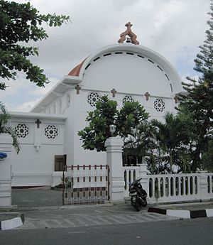
Bintaran (Javanese: ꦧꦶꦤ꧀ꦠꦫꦤ꧀) is a village in Wirogunan, Mergangsan, Yogyakarta, Indonesia. The area is known for its Dutch-Javanese architecture. It was formerly a Catholic settlement.

Gembira Loka Zoo
Zoo in Yogyakarta, Indonesia
Distance: Approx. 1792 meters
Latitude and longitude: -7.803968,110.3978733
Gembira Loka Zoo (Indonesian: Kebun Binatang Gembira Loka; Javanese: ꦏꦼꦧꦺꦴꦤ꧀ꦫꦗꦒꦼꦩ꧀ꦧꦶꦫꦭꦺꦴꦏ, romanized: Kêbon Raja Gêmbira Loka) is a zoological garden located in Yogyakarta, Special Region of Yogyakarta, Indonesia. Gembira Loka Zoo was opened in 1956 and comprises a botanical garden, orchid nursery, (artificial) lake, children's park, numerous scenic bridges across the Gajahwong River, and a collection of approximately 470 animals, most notable of which are its native Indonesian tigers, leopards, Komodo dragons, saltwater crocodiles, orangutans, and gibbons, as well as African animals such as lions, camels and hippopotamus. The park is 54 acres (21.8 hectares) in size.
Among Rogo Sports Hall
Multifunction sports arena in Special Region of Yogyakarta, Indonesia
Distance: Approx. 2202 meters
Latitude and longitude: -7.79801001,110.38529013
Among Rogo Sports Hall (Indonesian: Gelanggang Olahraga Among Rogo) is a multifunction sports arena in Semaki, Umbulharjo, Yogyakarta, Special Region of Yogyakarta, Indonesia. This arena can be used for basketball, badminton, volleyball, futsal, and taekwondo venues.

Yogyakarta metropolitan area
Metropolitan area in Special Region of Yogyakarta, Indonesia
Distance: Approx. 3245 meters
Latitude and longitude: -7.80138889,110.36444444
The Greater Yogyakarta, known locally as Kartamantul (Javanese: ꦏꦂꦠꦩꦤ꧀ꦠꦸꦭ꧀, romanized: Kartamantul), an acronym of Yogyakarta–Sleman–Bantul, is a built-up area in Special Region of Yogyakarta, Indonesia. Although unofficial, the Greater Yogyakarta sometimes referred to as the Yogyakarta metropolitan area.
Weather in this IP's area
overcast clouds
25 Celsius
26 Celsius
25 Celsius
25 Celsius
1011 hPa
88 %
1011 hPa
1001 hPa
10000 meters
0.22 m/s
1.24 m/s
212 degree
100 %
05:09:41
17:34:22

