Country:
Region:
City:
Latitude and Longitude:
Time Zone:
Postal Code:
IP information under different IP Channel
ip-api
Country
Region
City
ASN
Time Zone
ISP
Blacklist
Proxy
Latitude
Longitude
Postal
Route
Luminati
Country
ASN
Time Zone
Asia/Shanghai
ISP
CHINA UNICOM China169 Backbone
Latitude
Longitude
Postal
IPinfo
Country
Region
City
ASN
Time Zone
ISP
Blacklist
Proxy
Latitude
Longitude
Postal
Route
db-ip
Country
Region
City
ASN
Time Zone
ISP
Blacklist
Proxy
Latitude
Longitude
Postal
Route
ipdata
Country
Region
City
ASN
Time Zone
ISP
Blacklist
Proxy
Latitude
Longitude
Postal
Route
Popular places and events near this IP address

Lhasa
Urban district of the City of Lhasa in Tibet
Distance: Approx. 745 meters
Latitude and longitude: 29.65388889,91.1175
Lhasa, officially the Chengguan District of Lhasa City, is the inner urban district of Lhasa City, Tibet Autonomous Region, Southwestern China. Lhasa is the second most populous urban area on the Tibetan Plateau after Xining and, at an altitude of 3,656 metres (11,990 ft), Lhasa is one of the highest cities in the world. The city has been the religious and administrative capital of Tibet since the mid-17th century.

Potala Palace
Fortress in Lhasa, Tibet
Distance: Approx. 1178 meters
Latitude and longitude: 29.65777778,91.11694444
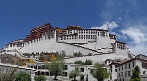
The Potala Palace is a dzong fortress in Lhasa, capital of the Tibet Autonomous Region in China. It was the winter palace of the Dalai Lamas from 1649 to 1959, has been a museum since then, and a World Heritage Site since 1994. The palace is named after Mount Potalaka, the mythical abode of the bodhisattva Avalokiteśvara.

Chagpori
Spirit-mountain in Tibet
Distance: Approx. 948 meters
Latitude and longitude: 29.6522043,91.1094743
Chagpori, Chakpori, Chokpori, Chagpo Ri (Wylie: lcags po ri, literally "Iron Mountain") is a spirit-mountain of Vajrapani in Lhasa, Tibet. It is south of Potala and just to the left when one is facing the Potala. It is considered to be one of the four holy mountains of central Tibet.

Zhol Village
Village in Lhasa, Tibet, China
Distance: Approx. 1193 meters
Latitude and longitude: 29.657917,91.117167
Zhol Village, or Shol Village (Chinese: 雪城; often transcribed as Zhöl or Shöl Village), is a village at the base of the Potala Palace in Lhasa, Tibet. It contained the residences and administrative buildings of Ganden Phodrang's government officials and other Tibetans. It was a favorite haunt of the 6th Dalai Lama.

Monument to the Peaceful Liberation of Tibet
Monument in People's Republic of China
Distance: Approx. 652 meters
Latitude and longitude: 29.65305556,91.11722222
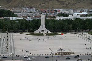
The Monument to the Peaceful Liberation of Tibet (Chinese: 西藏和平解放纪念碑) stands in the southern part of the Potala square in Lhasa, Tibet Autonomous Region just outside the protective zone and buffer zone of the World Heritage Site. It celebrates what the People's Republic of China calls the "Peaceful Liberation of Tibet" by the People's Liberation Army, or what the exiled Tibetan government calls the invasion and annexation of Tibet. The foundation stone was laid on July 18, 2001 by Hu Jintao, China's vice-president at the time.

Treasure of the Plateau
Sculpture in Lhasa, Tibet, China
Distance: Approx. 1209 meters
Latitude and longitude: 29.65563,91.10952
The Treasure of the Plateau (Chinese: 高原之宝) is an urban sculpture in Lhasa, Tibet Autonomous Region, China.
Chagpori Park
Park in Lhasa, Tibet, China
Distance: Approx. 1174 meters
Latitude and longitude: 29.65555556,91.11
Chagpori Park (Chinese: 药王山公园), located in Chengguan District, Lhasa, Tibet Autonomous Region, China.
Shirin Dorje Pohang
Distance: Approx. 605 meters
Latitude and longitude: 29.64878,91.11142
Shirin Dorje Pohang or Shirin Dorjee Pho Zhang (Chinese: 雪林多吉颇章, Wylie: zhol gling rdo rje pho brang, ZYPY: ཞོལ་གླིང་རྡོ་རྗེ་ཕོ་བྲང) is the palace of Panchen Lama, located in Lhasa, Tibet Autonomous Region, China.
Tibet Autonomous Region Mass Art Museum
Art museum in Lhasa, Tibet, China
Distance: Approx. 1034 meters
Latitude and longitude: 29.65008,91.12756
The Tibet Autonomous Region Mass Art Museum (Chinese: 西藏自治区群众艺术馆) is an autonomous region-level mass art museum in the Tibet Autonomous Region of China, located at No. 2 Dosenger Road in Lhasa.
Tibet Autonomous Region Guesthouse
Distance: Approx. 842 meters
Latitude and longitude: 29.65394,91.12134
The Tibet Autonomous Region Guesthouse (Chinese: 西藏自治区迎宾馆) is the official reception center of the Tibet Autonomous Region of the People's Republic of China, subordinate to the General Office of the Tibet Autonomous Regional Committee of the Chinese Communist Party, and is located on Yutuo Road in Lhasa. Originally built in 1965 to welcome the establishment of the Tibet Autonomous Region, it underwent a large-scale renovation and expansion in 2002. The building was a landmark of Lhasa in the 1960s and one of the outstanding buildings in Lhasa in the 1960s.
Lhasa Cinema City
Movie theater in Lhasa, Tibet, China
Distance: Approx. 1155 meters
Latitude and longitude: 29.65233,91.12778
Lhasa Cinema City (Chinese: 拉萨电影城), is a movie theater in Lhasa, Tibet Autonomous Region, China.

Potala Palace Square
Square in Lhasa, Tibet, China
Distance: Approx. 794 meters
Latitude and longitude: 29.65433,91.11707
Potala Palace Square (Chinese: 布达拉宫广场) is a large square in the center of Lhasa, Tibet Autonomous Region, China, located in the south side of the Potala Palace, formerly known as the Working People's Cultural Palace Square (Chinese: 劳动人民文化宫广场). In 1995, the Potala Palace Square was built on the basis of the original Tibetan Working People's Cultural Palace Square, and in August 1995, the Potala Palace Square was handed over to the management of the Tibetan Working People's Cultural Palace. The Potala Palace Square was rebuilt and expanded in 2005.
Weather in this IP's area
clear sky
3 Celsius
2 Celsius
3 Celsius
3 Celsius
1016 hPa
48 %
1016 hPa
660 hPa
10000 meters
2.03 m/s
2.1 m/s
173 degree
08:16:50
19:02:26