103.29.193.193 - IP Lookup: Free IP Address Lookup, Postal Code Lookup, IP Location Lookup, IP ASN, Public IP
Country:
Region:
City:
Location:
Time Zone:
Postal Code:
IP information under different IP Channel
ip-api
Country
Region
City
ASN
Time Zone
ISP
Blacklist
Proxy
Latitude
Longitude
Postal
Route
Luminati
Country
ASN
Time Zone
Australia/Sydney
ISP
Sliced Tech Holdings Unit Trust
Latitude
Longitude
Postal
IPinfo
Country
Region
City
ASN
Time Zone
ISP
Blacklist
Proxy
Latitude
Longitude
Postal
Route
IP2Location
103.29.193.193Country
Region
australian capital territory
City
waramanga
Time Zone
Australia/Sydney
ISP
Language
User-Agent
Latitude
Longitude
Postal
db-ip
Country
Region
City
ASN
Time Zone
ISP
Blacklist
Proxy
Latitude
Longitude
Postal
Route
ipdata
Country
Region
City
ASN
Time Zone
ISP
Blacklist
Proxy
Latitude
Longitude
Postal
Route
Popular places and events near this IP address

Weston, Australian Capital Territory
Suburb of Canberra, Australian Capital Territory
Distance: Approx. 1693 meters
Latitude and longitude: -35.338,149.059
Weston (postcode: 2611) is a suburb of Canberra, Australian Capital Territory, Australia. At the 2021 census, Weston had a population of 4,000 people. Weston was named after a former homestead built in the area sometime around 1835.

Weston Creek
Place in Australian Capital Territory
Distance: Approx. 1891 meters
Latitude and longitude: -35.33666667,149.05638889
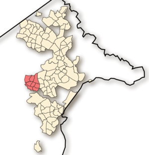
Weston Creek is a district in the Australian Capital Territory in Australia. The district is subdivided into divisions (suburbs), sections and blocks. The district comprises eight residential suburbs, situated to the west of the Woden Valley district and approximately 13 kilometres (8.1 mi) southwest of the Canberra City centre.

Waramanga, Australian Capital Territory
Suburb of Canberra, Australian Capital Territory
Distance: Approx. 82 meters
Latitude and longitude: -35.353,149.063
Waramanga () (postcode: 2611) is a suburb of Canberra, Australian Capital Territory, Australia in the district of Weston Creek. Waramanga was established in the late-1960s and was named after the Warumungu people of Central Australia. Streets in the suburb of Warramanga are named after Australian Aborignal people.

Chapman, Australian Capital Territory
Suburb of Canberra, Australian Capital Territory
Distance: Approx. 2055 meters
Latitude and longitude: -35.357,149.04
Chapman is a suburb of Canberra, Australian Capital Territory, Australia, where many diplomats and some of the wealthier citizens of Canberra chose to take their residency. It is located in the Weston Creek area. The suburb is named after Sir Austin Chapman (1864–1926), the member for Eden-Monaro from 1901 to 1926 who held portfolios in the Deakin and Bruce governments.

Fisher, Australian Capital Territory
Suburb of Canberra, Australian Capital Territory
Distance: Approx. 1004 meters
Latitude and longitude: -35.361,149.057
Fisher is a suburb of Canberra, Australian Capital Territory, Australia located in the district of Weston Creek. Fisher was named after Andrew Fisher (1862–1928), coal miner, founding member of the federal parliamentary Labor Party and Prime Minister of Australia for three terms between 1908 and 1915 (ACTLIC, 2004). The theme for the street names in Fisher is Australian mines and mining towns (ACTPLA, 2003).

Stirling, Australian Capital Territory
Suburb of Canberra, Australian Capital Territory
Distance: Approx. 1185 meters
Latitude and longitude: -35.349,149.05
Stirling is a suburb of Canberra, Australian Capital Territory, Australia. It is located in the Weston Creek district. The suburb is named after Sir James Stirling (1791–1865) who was the first Governor of Western Australia between 1829–1839 and established settlements at Perth and Fremantle in 1829.
Chifley, Australian Capital Territory
Suburb of Canberra, Australian Capital Territory
Distance: Approx. 1439 meters
Latitude and longitude: -35.35111111,149.07777778
Chifley (postcode: 2606) is a suburb of Canberra, Australia, in the district of Woden Valley. The suburb's area is 1.6 square kilometres (0.62 sq mi). It was named after Joseph Benedict Chifley, Prime Minister of Australia from July 1945 to December 1949.

Lyons, Australian Capital Territory
Suburb of Canberra, Australian Capital Territory
Distance: Approx. 1759 meters
Latitude and longitude: -35.342,149.076
Lyons is a suburb in the Canberra, Australia district of Woden. The postcode is 2606. The suburb was named after Joseph Lyons, Labor Premier of Tasmania from 1923 to 1928 and a Minister in the James Scullin government from 1929 until his resignation from the Labor Party in March 1931.
Mount Stromlo High School
Public high school
Distance: Approx. 665 meters
Latitude and longitude: -35.355,149.0552
Mount Stromlo High School is a public high school located in Waramanga, Australian Capital Territory. Mount Stromlo came into being after the merger of Weston Creek high school & Holder high school in 1990. The school is a traditional coeducational public school for students in year 7-10 aged 12-16.
Alliance Institute for Mission
Distance: Approx. 625 meters
Latitude and longitude: -35.35003333,149.05625556
Alliance Institute for Mission is an evangelical Christian theological institute based in Rhodes, New South Wales, Sydney, Australia. It is affiliated with the Christian & Missionary Alliance of Australia.
Oakey Hill
Distance: Approx. 1782 meters
Latitude and longitude: -35.33773,149.068
Oakey Hill is a hill near Canberra, Australian Capital Territory. It rises 80 metres (260 ft) above the adjacent south Canberra suburbs of Lyons, Curtin and Weston, and its 66 hectares (163 acres) is one of 33 areas which form Canberra Nature Reserve. The highest point of the hill, 684 metres above sea level, is marked by a survey station.

Cooleman Court
Australian sub-regional shopping centre
Distance: Approx. 1562 meters
Latitude and longitude: -35.3412,149.0528
Cooleman Court, sometimes known colloquially as "Coolo", is a sub-regional shopping centre located in the Weston Creek suburb of Weston, Australia. Cooleman Court offers a total of 80 stores and facilities, spanning indoor and outdoor space, replicating something of a town square. Its major tenant is Woolworths.
Weather in this IP's area
few clouds
31 Celsius
30 Celsius
29 Celsius
32 Celsius
1004 hPa
34 %
1004 hPa
926 hPa
10000 meters
6.69 m/s
320 degree
20 %