Country:
Region:
City:
Latitude and Longitude:
Time Zone:
Postal Code:
IP information under different IP Channel
ip-api
Country
Region
City
ASN
Time Zone
ISP
Blacklist
Proxy
Latitude
Longitude
Postal
Route
Luminati
Country
ASN
Time Zone
Asia/Tokyo
ISP
ARTERIA Networks Corporation
Latitude
Longitude
Postal
IPinfo
Country
Region
City
ASN
Time Zone
ISP
Blacklist
Proxy
Latitude
Longitude
Postal
Route
db-ip
Country
Region
City
ASN
Time Zone
ISP
Blacklist
Proxy
Latitude
Longitude
Postal
Route
ipdata
Country
Region
City
ASN
Time Zone
ISP
Blacklist
Proxy
Latitude
Longitude
Postal
Route
Popular places and events near this IP address

Naha
Capital city of Okinawa Prefecture, Japan
Distance: Approx. 944 meters
Latitude and longitude: 26.21222222,127.67916667
Naha (那覇市, Naha-shi, Japanese: [naꜜha], Okinawan: Nāfa or Nafa) is the capital city of Okinawa Prefecture, the southernmost prefecture of Japan. As of 1 June 2019, the city has an estimated population of 317,405 and a population density of 7,939 people per km2 (20,562 persons per sq. mi.).
Kumemura
Location of Ryukyu Kingdom bureaucracy
Distance: Approx. 679 meters
Latitude and longitude: 26.21744,127.675831
Kumemura (久米村, Okinawan: Kuninda; Middle Chinese: Kjú-méi ts'won) was an Okinawan community of scholars, bureaucrats, and diplomats in the port city of Naha near the royal capital of Shuri, which was a center of culture and learning during the time of the Ryukyu Kingdom. The people of Kumemura, traditionally believed to all be descendants of the Chinese immigrants who first settled there in 1392, came to form an important and aristocratic class of scholar-bureaucrats, the yukatchu, who dominated the royal bureaucracy, and served as government officials at home, and as diplomats in relations with China, Japan, and others. The community's special function came to an end in 1879, with Okinawa's formal annexation to Japan, and it has since been geographically absorbed into the prefectural capital of Naha; the area is now known simply as Kume.
Roman Catholic Diocese of Naha
Roman Catholic diocese in Japan
Distance: Approx. 944 meters
Latitude and longitude: 26.21222222,127.67916667
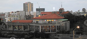
The Diocese of Naha (Latin: Dioecesis Nahana, Japanese: カトリック那覇教区) is a Latin Church diocese of the Catholic Church in the ecclesiastical province of the Metropolitan Nagasaki 長崎, in southern Japan. Its cathedral episcopal see is the Cathedral of the Immaculate Heart of Mary (Kainan Church), located in the city of Naha (on and administrative capital of Okinawa).

Naminoue Shrine
Distance: Approx. 718 meters
Latitude and longitude: 26.220636,127.671352
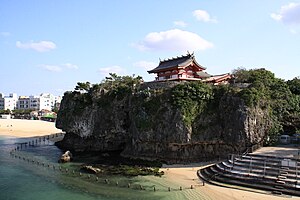
Naminoue Shrine (波上宮, Naminoue-gū) is a Shinto shrine in Naha, Okinawa Prefecture, Japan, the ichinomiya (primary shrine) of the prefecture. It sits atop a high bluff, overlooking Naminoue Beach and the ocean. Originally a sacred space of the native Ryukyuan religion, due to its location and natural beauty, it was dedicated to nirai kanai, the mythical source of all life, and to the sea.
Gokoku-ji (Okinawa)
Buddhist temple in Okinawa Prefecture, Japan
Distance: Approx. 667 meters
Latitude and longitude: 26.220112,127.671613
Gokoku-ji (護国寺, "Protection of the Nation Temple") is a Zen Buddhist temple in Naha, Okinawa. Established in 1367, the temple served as a major national temple for the Okinawan kingdom of Chūzan and the unified Ryūkyū Kingdom which would follow. It is well known for its associations with Christian missionary Bernard Jean Bettelheim and with the 1853-1854 visits by Commodore Matthew Perry to Okinawa.
Fukushūen
Distance: Approx. 721 meters
Latitude and longitude: 26.21797,127.675943
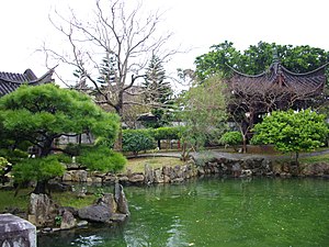
Fukushūen (福州園, lit. "Fuzhou Garden" or "Foochow Garden") is a traditional Chinese garden in the Kume area of Naha, Okinawa. The garden was constructed in 1992, in celebration of the 10th anniversary of the establishment of the sister city relationship between Naha and Fuzhou in China.

Shiseibyō
Distance: Approx. 576 meters
Latitude and longitude: 26.21916667,127.67194444
The Shiseibyō (至聖廟) is a Confucian temple in the Wakasa district of Naha, Okinawa. It served for centuries as a major center of Chinese learning for the Ryūkyū Kingdom, and contains within its precincts the Meirindō, first public school in Okinawa.

Naha Port Facility
United States Forces Japan facility in Naha, Okinawa, Japan
Distance: Approx. 743 meters
Latitude and longitude: 26.20833333,127.66666667
The Naha Port Facility, formerly the Naha Military Port, is a United States Forces Japan facility located in Naha, Okinawa, Japan, at the mouth of Kokuba River (国場川, Kokuba-gawa), which flows into the East China Sea. The Naha Military Port was constructed by the U.S. troops after their landing on Okinawa Island in 1945. In 1950, Yarazamori Castle was demolished to make room for the port facility.

Asahibashi Station
Monorail station in Naha, Okinawa Prefecture, Japan
Distance: Approx. 566 meters
Latitude and longitude: 26.2119,127.675
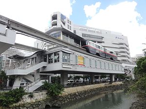
Asahibashi Station (旭橋駅, Asahibashi-eki) is one of the railway station on the Okinawa Urban Monorail (Yui Rail) located in Naha, Okinawa Prefecture, Japan.

Prefectural Office Station
Monorail station in Naha, Okinawa Prefecture, Japan
Distance: Approx. 899 meters
Latitude and longitude: 26.2144,127.679
Prefectural Office Station (県庁前駅, Kenchō-mae-eki) is a railway station on the Okinawa Urban Monorail (Yui Rail) in Naha, Okinawa Prefecture, Japan.
Mie Castle
Ryukyuan gusuku in Naha, Okinawa, Japan
Distance: Approx. 493 meters
Latitude and longitude: 26.2138,127.6651
Mie Castle (三重城, Mie jō, Okinawan: Mii gushiku) is a Ryukyuan gusuku in Naha, Okinawa. It is located on the northern mouth of the Kokuba River in Naha Port.

Naha City Museum of History
Building in Okinawa Prefecture, Japan
Distance: Approx. 926 meters
Latitude and longitude: 26.21378075,127.67925408
Naha City Museum of History (那覇市歴史博物館, Naha-shi Rekishi Hakubutsukan) opened in Naha, Okinawa Prefecture, Japan, in 2006. The collection includes the National Treasure Materials relating to the Shō Family of Ryūkyū Kings. The digital museum was launched in 2014.
Weather in this IP's area
light intensity shower rain
25 Celsius
26 Celsius
23 Celsius
25 Celsius
1013 hPa
95 %
1013 hPa
1012 hPa
10000 meters
3.09 m/s
50 degree
75 %
06:48:45
17:39:41


