Country:
 Brazil
Region:
City:
Latitude and Longitude:
Time Zone:
Postal Code:
IP information under different IP Channel
ip-api
Country
Region
City
ASN
Time Zone
ISP
Blacklist
Proxy
Latitude
Longitude
Postal
Route
IPinfo
Country
Region
City
ASN
Time Zone
ISP
Blacklist
Proxy
Latitude
Longitude
Postal
Route
MaxMind
Country
Region
City
ASN
Time Zone
ISP
Blacklist
Proxy
Latitude
Longitude
Postal
Route
Luminati
Country
 SG
SGASN
Time Zone
Asia/Singapore
ISP
HUAWEI CLOUDS
Latitude
Longitude
Postal
db-ip
Country
Region
City
ASN
Time Zone
ISP
Blacklist
Proxy
Latitude
Longitude
Postal
Route
ipdata
Country
Region
City
ASN
Time Zone
ISP
Blacklist
Proxy
Latitude
Longitude
Postal
Route
Popular places and events near this IP address

São Paulo
Most populous city in Brazil
Distance: Approx. 56 meters
Latitude and longitude: -23.55,-46.63333333
São Paulo (, Brazilian Portuguese: [sɐ̃w ˈpawlu] ; Portuguese for 'Saint Paul') is the most populous city in Brazil and the capital of the state of São Paulo. Listed by the Globalization and World Cities Research Network (GaWC) as an alpha global city, it exerts substantial international influence in commerce, finance, arts, and entertainment. It is the largest urban area by population outside Asia and the most populous Portuguese-speaking city in the world.
Cajamar, São Paulo
Municipality in the state of São Paulo in Brazil
Distance: Approx. 65 meters
Latitude and longitude: -23.55027778,-46.63388889
Cajamar is a municipality in the State of São Paulo, Brazil. It is part of the Metropolitan Region of São Paulo. The population is 77,934 (2020 est.) in an area of 131.39 km².
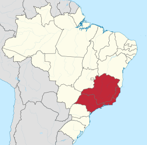
Southeast Region, Brazil
Region in Brazil
Distance: Approx. 56 meters
Latitude and longitude: -23.55,-46.63333333
The Southeast Region of Brazil (Portuguese: Região Sudeste do Brasil [ʁeʒiˈɐ̃w suˈdɛstʃi du bɾaˈziw]) is composed of the states of Espírito Santo, Minas Gerais, Rio de Janeiro and São Paulo. It is the richest region of the country, responsible for approximately 60% of the Brazilian GDP, as São Paulo, Rio de Janeiro, and Minas Gerais are the three richest states of Brazil, the top three Brazilian states in terms of GDP. The Southeast of Brazil also has the highest GDP per capita among all Brazilian regions. The Southeast region accounts for about 44% of Brazil's total population, leading the country in population, urban population, population density, vehicles, industries, universities, airports, ports, highways, hospitals, schools, houses and many other areas.

São Paulo Cathedral
Cathedral in Brazil
Distance: Approx. 130 meters
Latitude and longitude: -23.551168,-46.63434
The Metropolitan Cathedral of Our Lady Assumption and Saint Paul (Portuguese: Catedral Metropolitana de Nossa Senhora da Assunção e São Paulo), also known as the See Cathedral (Portuguese: Catedral da Sé), is the cathedral of the Roman Catholic Archdiocese of São Paulo, Brazil. Its current and seventh metropolitan archbishop is Dom Odilo Pedro Cardinal Scherer, appointed by Pope Benedict XVI on March 21, 2007, and installed on April 29 of the same year. The existing cathedral's construction, in a Gothic revival style, began in 1913 and ended four decades later.
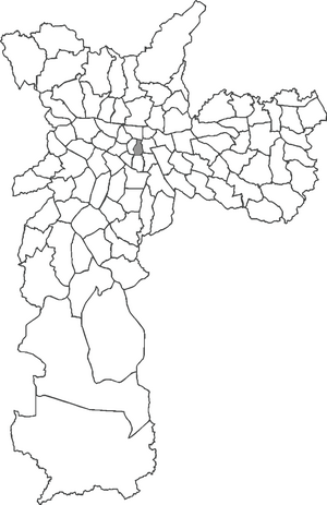
Sé (district of São Paulo)
District of São Paulo, Brazil
Distance: Approx. 112 meters
Latitude and longitude: -23.55111112,-46.63416668
Sé is the name of the most central borough in the city of São Paulo, in Brazil, divided in eight districts. The name comes from the presence of São Paulo Cathedral (Catedral da Sé) in the borough, and it is also the name of the central square (Praça da Sé). Also located in the Sé are the Pátio do Colégio, site of the foundation of the city in 1554, the São Paulo stock exchange (the Bovespa), the mayor's palace and other historical buildings, including the Municipal Theater of São Paulo, the São Paulo Music Hall (Sala São Paulo) and the central railway Luz Station (Estação da Luz).

Praça da Sé
Distance: Approx. 65 meters
Latitude and longitude: -23.55027778,-46.63388889
Praça da Sé (English: See Square) is a public space in São Paulo, Brazil. Considered as the city's central point, it is the point from where the distance of all roads passing through São Paulo are counted. The square was the location of many historical events in São Paulo's history, most notably during the Diretas Já movement.

Sé (São Paulo Metro)
São Paulo Metro station
Distance: Approx. 25 meters
Latitude and longitude: -23.55059,-46.633522
Sé is a central station on Line 1 (Blue) and Line 3 (Red) of the São Paulo Metro. It is located under the Praça da Sé, next to the São Paulo Cathedral. It was officially inaugurated on 17 February 1978.

Subprefecture of Mooca
Subprefecture in Southeast, Brazil
Distance: Approx. 114 meters
Latitude and longitude: -23.5511,-46.6342
The Subprefecture of Mooca is one of 32 subprefectures of the city of São Paulo, Brazil. It comprises six districts: Brás, Mooca, Belém, Pari, Água Rasa, and Tatuapé. It's a historical place of the city, where much of the industrial development of the city took place.

Subprefecture of Sé
Subprefecture in Southeast, Brazil
Distance: Approx. 114 meters
Latitude and longitude: -23.5511,-46.6342
The Subprefecture of Sé is one of 32 subprefectures of the city of São Paulo, Brazil. It comprises eight districts: Bela Vista, Bom Retiro, Cambuci, Consolação, Liberdade, República, Sé, Santa Cecília. This subprefecture forms the inner city, historical core of the city.

Trolleybuses in São Paulo
Distance: Approx. 56 meters
Latitude and longitude: -23.55,-46.63333333
Trolleybuses in São Paulo provide a portion of the public transport service in Greater São Paulo, in the state of São Paulo, Brazil, with two independent trolleybus systems.: 15 The SPTrans (São Paulo Transportes) system opened in 1949 and serves the city of São Paulo, while the Empresa Metropolitana de Transportes Urbanos de São Paulo (EMTU) system opened in 1988 and serves suburban areas to the southeast of the city proper. Worldwide, São Paulo is the only metropolitan area possessing two independent trolleybus systems.

Marco Zero (São Paulo)
Geographic monument in São Paulo, Brazil
Distance: Approx. 68 meters
Latitude and longitude: -23.550385,-46.633956
Marco Zero (Zero Milestone) is a geographic monument in downtown São Paulo. In 1934, the marble milestone was installed in front of the São Paulo Cathedral on the Praça da Sé to symbolize the center of the city. The sculpture is a both a tourist attraction and a central point of reference for street numbers in the city.

Bahia State University
University in Bahia, Brazil
Distance: Approx. 56 meters
Latitude and longitude: -23.55,-46.63333333
State University of Bahia (Portuguese: Universidade do Estado da Bahia, UNEB) is a public university in the Brazilian state of Bahia. Founded in 1983, the university regrouped existing schools in the state of Bahia. The university is included Technical Education Center of Bahia, the Faculty of Agronomy of the Middle San Francisco (Brazilian river), the schools of education of Alagoinhas, Jacobina, and Santo Antônio de Jesus, and the Faculties of Philosophy, Sciences and Letters of Caetité a Juazeiro.
Weather in this IP's area
clear sky
24 Celsius
24 Celsius
23 Celsius
25 Celsius
1018 hPa
72 %
1018 hPa
932 hPa
10000 meters
3.09 m/s
70 degree
06:10:12
17:58:18