103.254.186.153 - IP Lookup: Free IP Address Lookup, Postal Code Lookup, IP Location Lookup, IP ASN, Public IP
Country:
Region:
City:
Location:
Time Zone:
Postal Code:
IP information under different IP Channel
ip-api
Country
Region
City
ASN
Time Zone
ISP
Blacklist
Proxy
Latitude
Longitude
Postal
Route
Luminati
Country
ASN
Time Zone
Asia/Kathmandu
ISP
WorldLink Communications Pvt Ltd
Latitude
Longitude
Postal
IPinfo
Country
Region
City
ASN
Time Zone
ISP
Blacklist
Proxy
Latitude
Longitude
Postal
Route
IP2Location
103.254.186.153Country
Region
lumbini
City
butwal
Time Zone
Asia/Kathmandu
ISP
Language
User-Agent
Latitude
Longitude
Postal
db-ip
Country
Region
City
ASN
Time Zone
ISP
Blacklist
Proxy
Latitude
Longitude
Postal
Route
ipdata
Country
Region
City
ASN
Time Zone
ISP
Blacklist
Proxy
Latitude
Longitude
Postal
Route
Popular places and events near this IP address

Butwal
Sub-Metropolitan City, Rupandehi Nepal
Distance: Approx. 1736 meters
Latitude and longitude: 27.7,83.466
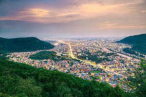
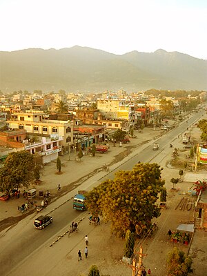
Butwal (Nepali: बुटवल), officially Butwal Sub-Metropolitan City (Nepali: बुटवल उपमहानगरपालिका),previously known as Khasyauli (Nepali: खस्यौली), is a sub-metropolitan city and economic hub in Lumbini Province in West Nepal. Butwal has a city population of 195,054 as per the 2021 AD Nepal census. The city is one of the tetra-cities of rapidly growing Butwal-Tilottama-Bhairahawa-Devdaha urban agglomeration primarily based on the Siddhartha Highway in West Nepal with a total urban agglomerated population of 4,74,541.
Motipur, Rupandehi
Village Development Committee in Lumbini Province, Nepal
Distance: Approx. 4059 meters
Latitude and longitude: 27.66666667,83.43333333
Motipur is a Village Development Committee in Rupandehi District in Lumbini Province of southern Nepal. At the time of the 1991 Nepal census it had a population of 5601 people residing in 927 individual households. It is now combined with Butwal municipality to form Butwal sub-metropolitan city.

Karahiya, Rupandehi
Place in Western, Nepal
Distance: Approx. 171 meters
Latitude and longitude: 27.7,83.45
Karahiya is a town in Tilottama Municipality in Rupandehi District in Lumbini Province of southern Nepal. The former village development committee was merged to form the new municipality on 18 May 2014. It is located halfway between Butwal and Bhairahawa in the foothills of Chhure range and on the bank of Tinau River.

Siddha Baba Temple
Shiva temple in Nepal
Distance: Approx. 3104 meters
Latitude and longitude: 27.72196111,83.46864167
Siddha Baba Temple (Nepali: श्री सिद्धबाबा मन्दिर) is a Hindu temple of Shiva located near the city of Butwal, Dobhan-5, Palpa district of Nepal. The temple is visited by the people all over Nepal and mostly by the Hindus of Palpa and Rupandehi and neighboring districts. It is believed that the wishes of the devotees who visit the temple comes true.

Eden English Boarding High School
Coeducational school in Butwal, Rupandehi District, Nepal
Distance: Approx. 1858 meters
Latitude and longitude: 27.68394444,83.44719444
Eden English Boarding High School (Nepali: ईडन इंग्लिश बोर्डिगं हाई स्कूल) is a school located in Butwal city, Rupandehi District. Though the school is located on Butwal Sub-metro but focuses on the students to be collected from mid-urban communities of nearby areas.
Butwal Technical Institute
School
Distance: Approx. 1986 meters
Latitude and longitude: 27.708364,83.4665426
The Butwal Technical Institute (BTI) is a community based technical school located in Butwal, Nepal. The school was established in 1963 by United Mission to Nepal (UMN) in the leadership of Odd Hoftun, a Norwegian Engineer. At that time, Odd Hoftun was deputed for the construction of Tansen Mission Hospital by UMN. During the construction of the hospital, he could not find local skilled people.

Kanti Higher Secondary School
Government-run community school in Lumbini Pradesh, Nepal
Distance: Approx. 1784 meters
Latitude and longitude: 27.707,83.465
Kanti Higher Secondary School (Nepali: कान्ति उच्च माध्यमिक विद्यालय ) is a government - run community school in Butwal, Nepal. The school is one of few community schools providing courses in English language. The school was established in 2010 B.S. The school partially rents the space for the commercial business to raise fund to run the school and provide scholarships to the students.

Jit Gadhi
Distance: Approx. 1144 meters
Latitude and longitude: 27.7034416,83.45955423
The Jit Gadhi (Nepali: जितगढी; historically known as Butwal Gadhi) is a fort in Butwal, Lumbini Province, Nepal. It was built by the Sen dynasty. The fort was used during the Anglo-Nepalese War (1814–1816) where Colonel Ujir Singh Thapa led Nepal's victory in the Battle of Jitgadhi against the East India Company.
Battle of Jit Gadhi
1814 battle between Nepal and the East India Company
Distance: Approx. 1144 meters
Latitude and longitude: 27.7034416,83.45955423
The Battle of Jit Gadhi (Nepali: जितगढीको युद्ध; sometimes referred to as Jit Gadh) was fought in 1814 in Jit Gadhi, Lumbini Province between Nepal and the East India Company. It resulted in Nepalese victory. The battle was commanded by Ujir Singh Thapa and John Sullivan Wood.

Padma Chaitya Bihar
Buddhist monastery in Butwal, Nepal
Distance: Approx. 1072 meters
Latitude and longitude: 27.7065,83.457
Padma Chaitya Vihar is a Buddhist monastery located in Butwal, Nepal. It was established in 1971 BS (1914-1915) when the Newar people came for settlement in this area. It is believed that the monastery was established before any significant settlement occurred in Butwal.

Manimukunda Sen Park
Public park in Butwal, Nepal
Distance: Approx. 922 meters
Latitude and longitude: 27.7062962,83.455195
Manimukunda Sen Park(Nepali: माणिमुकुन्द उद्यान), locally known as Phulbari(Nepali: फुलबारी), is a historic site and a major tourist attraction in Rupandehi district of Nepal. The park houses a ruin of palace of king Manimukunda Sen of medieval Palpa Kingdom. The park is located in western side of Butwal city.
Butwal International Conference Centre
Convention centre in Butwal, Nepal
Distance: Approx. 2883 meters
Latitude and longitude: 27.6848015,83.471582
Butwal International Conference Centre (Nepali: बुटवल अन्तराष्ट्रिय सम्मेलन केन्द्र) is the largest convention center in Nepal. The assembly hall was constructed in 6.4 Bighas (approx 42,649 m2)of land at a cost of NPR 2.5 billion. The assembly hall has a capacity of 10,000 people.
Weather in this IP's area
scattered clouds
15 Celsius
14 Celsius
15 Celsius
15 Celsius
1018 hPa
55 %
1018 hPa
985 hPa
10000 meters
2.24 m/s
1.86 m/s
24 degree
35 %