Country:
 New Zealand
Region:
City:
Latitude and Longitude:
Time Zone:
Postal Code:
IP information under different IP Channel
ip-api
Country
Region
City
ASN
Time Zone
ISP
Blacklist
Proxy
Latitude
Longitude
Postal
Route
IPinfo
Country
Region
City
ASN
Time Zone
ISP
Blacklist
Proxy
Latitude
Longitude
Postal
Route
MaxMind
Country
Region
City
ASN
Time Zone
ISP
Blacklist
Proxy
Latitude
Longitude
Postal
Route
Luminati
Country
NZRegion
ota
ASN
Time Zone
Pacific/Auckland
ISP
Wicked Networks
Latitude
Longitude
Postal
db-ip
Country
Region
City
ASN
Time Zone
ISP
Blacklist
Proxy
Latitude
Longitude
Postal
Route
ipdata
Country
Region
City
ASN
Time Zone
ISP
Blacklist
Proxy
Latitude
Longitude
Postal
Route
Popular places and events near this IP address
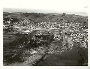
Abbotsford, New Zealand
Suburb in Dunedin, New Zealand
Distance: Approx. 665 meters
Latitude and longitude: -45.897,170.426
Abbotsford is a suburb of the New Zealand city of Dunedin. It is located to the west of the city centre. It is Immediately to the north of Green Island, and separated from it by State Highway 1 and South Island Main Trunk Railway (opened to Green Island in 1874).

Anglican Diocese of Dunedin
Distance: Approx. 437 meters
Latitude and longitude: -45.902907,170.428629
The Diocese of Dunedin is one of the thirteen dioceses and hui amorangi (Māori bishoprics) of the Anglican Church in Aotearoa, New Zealand and Polynesia. The diocese covers the same area as the provinces of Otago and Southland in the South Island of New Zealand; or approximately 65,990 square kilometres (25,480 sq mi), with a population 272,541 (in 2001). Anglicans are traditionally the third largest religious group in Otago and Southland after Presbyterians and Roman Catholics.
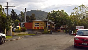
Fairfield School, Dunedin
Primary and intermediate (year 0-8) school
Distance: Approx. 2449 meters
Latitude and longitude: -45.900647,170.391515
Fairfield School is a Primary and Intermediate school in Dunedin, New Zealand. The school was established during the late 19th century in the suburb of Fairfield by William Martin. It is situated on Sickels Street near the Dunedin Southern Motorway.

Fairfield, Otago
Suburb in Dunedin, New Zealand
Distance: Approx. 1805 meters
Latitude and longitude: -45.9,170.4
Fairfield is a suburb of Dunedin, New Zealand. Fairfield lies in rolling hill country, close to the slopes of Saddle Hill and Scroggs Hill. The name Fairfield was originally given as a descriptive name by early European settler William Martin to his farm property, located close to where the town now stands.
Waldronville
Suburb in Dunedin, New Zealand
Distance: Approx. 2757 meters
Latitude and longitude: -45.92361111,170.40416667
Waldronville is a coastal settlement on the Pacific Ocean coast of the South Island of New Zealand. Established in the 1950s as a commuter settlement, it is located 13 kilometres (8.1 mi) to the southwest of Dunedin city centre, and lies within the city's limits. Waldronville was developed by Bill Waldron, when he purchased the McCraws farm in the early 1950s, initially for 200 houses.
Concord, New Zealand
Suburb in Dunedin, New Zealand
Distance: Approx. 2635 meters
Latitude and longitude: -45.902,170.457
Concord is a small residential suburb of the New Zealand city of Dunedin. It is southwest of the city centre. It lay on State Highway 1 until the construction of the Dunedin Southern Motorway in the 1990s, but is now bypassed by traffic from central Dunedin.
Sunnyvale Park
Distance: Approx. 763 meters
Latitude and longitude: -45.9,170.41388889
Sunnyvale Park is a multi-use sports venue in Dunedin, New Zealand. It is located immediately to the west of Abbotsford in Sunnyvale, near Green Island, and is bounded by Main South Road, Dunedin Southern Motorway and Abbot's Creek, a tributary of the Kaikorai Stream. The park is currently used primarily for football (soccer), being a former home ground for Otago United in the New Zealand Football Championship, as well as local club side Green Island.
Burnside, Dunedin
Suburb in Dunedin, New Zealand
Distance: Approx. 2531 meters
Latitude and longitude: -45.898,170.455
Burnside is a mainly industrial suburb of the New Zealand city of Dunedin. It is located at the mouth of a long valley, the Kaikorai Valley, through which flows the Kaikorai Stream. This valley stretches to the northeast for 3.5 kilometres (2.2 mi).
1979 Abbotsford landslip
Distance: Approx. 1097 meters
Latitude and longitude: -45.897095,170.434739
On 8 August 1979, a major landslip occurred in the Dunedin, New Zealand, suburb of Abbotsford. It was the largest landslide in a built-up area in New Zealand's history, resulting in the destruction of 69 houses – around one sixth of the suburb – but no fatalities.

Green Island, New Zealand
Suburb in Dunedin, New Zealand
Distance: Approx. 586 meters
Latitude and longitude: -45.90277778,170.43055556
Green Island is a suburb of Dunedin, New Zealand. Not an actual island, this former borough takes its name from the Green Island bush, uncleared native forest extending from the valley where the community is centred over the hills towards the coast. The name of the nearby offshore island — Green Island (Okaihe) — was used to identify the bush and, thus, also lent its name to the mainland suburb.
Island Park Recreation Reserve
Distance: Approx. 3139 meters
Latitude and longitude: -45.92805556,170.40555556
Island Park Recreation Reserve is a coastal reserve in Waldronville, just to the southwest of Dunedin, New Zealand. The Kaikorai Stream and Westwood Recreation Reserve lie to the west. The reserve was established in 1977, coming into effect in 1978.

Blackhead (New Zealand)
Point in Dunedin, New Zealand
Distance: Approx. 3339 meters
Latitude and longitude: -45.93194444,170.43194444
Blackhead is a promontory on the coast of Otago, New Zealand. It lies within the city limits of Dunedin, some 10 kilometres (6.2 mi) southwest of the city centre. The promontory extends some 500 metres into the ocean, and rises to a height of a little over 100 metres (330 ft).
Weather in this IP's area
overcast clouds
10 Celsius
9 Celsius
10 Celsius
10 Celsius
1003 hPa
66 %
1003 hPa
1001 hPa
10000 meters
2.92 m/s
5.63 m/s
49 degree
99 %
06:55:06
18:17:22