Country:
 Chinese mainland
Region:
City:
Latitude and Longitude:
Time Zone:
Postal Code:
IP information under different IP Channel
ip-api
Country
Region
City
ASN
Time Zone
ISP
Blacklist
Proxy
Latitude
Longitude
Postal
Route
IPinfo
Country
Region
City
ASN
Time Zone
ISP
Blacklist
Proxy
Latitude
Longitude
Postal
Route
MaxMind
Country
Region
City
ASN
Time Zone
ISP
Blacklist
Proxy
Latitude
Longitude
Postal
Route
Luminati
Country
CNASN
Time Zone
Asia/Shanghai
ISP
CHINA UNICOM China169 Backbone
Latitude
Longitude
Postal
db-ip
Country
Region
City
ASN
Time Zone
ISP
Blacklist
Proxy
Latitude
Longitude
Postal
Route
ipdata
Country
Region
City
ASN
Time Zone
ISP
Blacklist
Proxy
Latitude
Longitude
Postal
Route
Popular places and events near this IP address
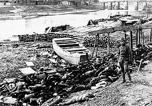
Nanjing Massacre
1937 mass murder of Chinese civilians by the Japanese army
Distance: Approx. 1240 meters
Latitude and longitude: 32.05,118.76666667
The Nanjing Massacre or the Rape of Nanjing (formerly romanized as Nanking) was the mass murder of Chinese civilians in Nanjing, the capital of the Republic of China, immediately after the Battle of Nanking and the retreat of the National Revolutionary Army in the Second Sino-Japanese War, by the Imperial Japanese Army. Beginning on December 13, 1937, the massacre lasted six weeks. The perpetrators also committed other war crimes such as mass rape, looting, torture, and arson.
Nanjing Normal University
Public university in Nanjing, Jiangsu. China
Distance: Approx. 529 meters
Latitude and longitude: 32.05611111,118.76444444
Nanjing Normal University (NJNU; Chinese: 南京师范大学; pinyin: Nánjīng Shīfàn Dàxué) is a provincial public university in Nanjing, Jiangsu, China. It is affiliated with the Province of Jiangsu, and co-sponsored by the Ministry of Education and the provincial government. The university is part of the Double First-Class Construction and Project 211.

Wang Jingwei regime
Puppet state of Japan in China (1940–1945)
Distance: Approx. 1240 meters
Latitude and longitude: 32.05,118.76666667
The Reorganized National Government of the Republic of China, commonly described as the Wang Jingwei regime, was a puppet state of the Empire of Japan in eastern China. It existed coterminous with the Nationalist government of the Republic of China under Chiang Kai-shek, which was fighting Japan alongside the other Allies of World War II. The country functioned as a dictatorship under Wang Jingwei, formerly a high-ranking official of the Nationalist Kuomintang (KMT). The region it administered was initially seized by Japan during the late 1930s at the beginning of the Second Sino-Japanese War.

Wutaishan Stadium
Stadium in Nanjing, China
Distance: Approx. 1200 meters
Latitude and longitude: 32.05103611,118.76863333
Wutaishan Stadium (Simplified Chinese: 五台山体育场) is a multi-purpose stadium in Wutaishan Sports Center (Simplified Chinese: 五台山体育中心), Nanjing, China. It is currently used mostly for football matches, as home ground of Nanjing City since 2024 and formerly for Jiangsu Ladies. The stadium has a capacity for 22,000 people.
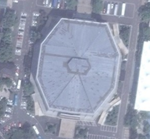
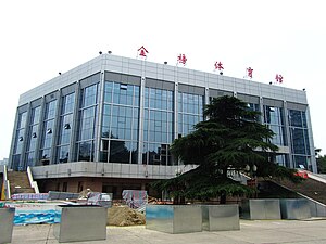
Wutaishan Gymnasium
Indoor arena in Nanjing, China
Distance: Approx. 1130 meters
Latitude and longitude: 32.05111111,118.76694444
The Wutaishan Gymnasium is an indoor arena in Nanjing, China. The arena is used mainly for indoor sports such as basketball, and it hosted the final round of the 2002 FIBA World Championship for Women. The facility has a capacity of 10,000 people.
Hohai University
Public university in Nanjing, Jiangsu, China
Distance: Approx. 857 meters
Latitude and longitude: 32.05888889,118.75416667
Hohai University (HHU; Chinese: 河海大学; pinyin: Héhǎi Dàxué) is a public university in Nanjing, Jiangsu, China. It is affiliated with the Ministry of Education of China, and co-sponsored by the Ministry of Education, the Ministry of Water Resources, the State Oceanic Administration, and the Jiangsu Provincial People's Government. The university is part of Project 211 and the Double First-Class Construction.

Gulou, Nanjing
District in Jiangsu, China
Distance: Approx. 1154 meters
Latitude and longitude: 32.064,118.7514
Gulou District (Chinese: 鼓楼区; pinyin: Gǔlóu Qū; lit. 'Drum tower') is one of 11 districts of Nanjing, the capital of Jiangsu province, China. It is named after the Drum Tower of Nanjing (Gulou).
Wutaishan Sports Center
Sports center in Nanjing, China
Distance: Approx. 1200 meters
Latitude and longitude: 32.05103611,118.76863333
Wutaishan Sports Center is a sports center in Nanjing, China. It was established in 1952 and it was one of the oldest and most advanced stadiums in early time of People's Republic of China. It is home to the Wutaishan Stadium.

Qingliangshan Park
Park in Nanjing, China
Distance: Approx. 1143 meters
Latitude and longitude: 32.05194444,118.75666667
Qingliangshan Park (Chinese: (清凉山公园; lit. 'cooling hill'), is a 73 hectares (180 acres) park located in the Gulou District, Nanjing, China. It sits on Qingliang Hill, which is more than 100 metres (330 ft) high and 4 kilometres (2.5 mi) in radius.
Timeline of Nanjing
Distance: Approx. 1240 meters
Latitude and longitude: 32.05,118.766667
The following is a timeline of the history of the city of Nanjing, Jiangsu Province, China.

Yunnanlu station
Railway station in Nanjing, Jiangsu, China
Distance: Approx. 609 meters
Latitude and longitude: 32.0612,118.76943
Yunnanlu station (Chinese: 云南路站), is a station on Line 4 of the Nanjing Metro, and a planned interchange station with the currently under-construction Line 5. It opened on January 18, 2017 alongside seventeen other stations as part of Line 4's first phase. The station is oriented on an east–west axis, underneath the intersection of Beijing West Road and Yunnan Road to the north and Shanghai Road to the south.

Jiangsu State Security Department
Provincial department of China's Ministry of State Security
Distance: Approx. 207 meters
Latitude and longitude: 32.05944,118.76139
The Jiangsu State Security Department (江苏省国家安全厅) is the provincial bureau of the Chinese Ministry of State Security in Jiangsu which serves as the coastal province's intelligence service and secret police. They are involved extensively in espionage against the United States, and aviation-related industrial espionage, operating the advanced persistent threat TURBINE PANDA, also known as APT26. They are most well known for their alleged responsibility for the high-profile 2015 hack of the United States Office of Personnel Management, stealing the personal details of over 20 million U.S. federal civil servants.
Weather in this IP's area
scattered clouds
28 Celsius
32 Celsius
28 Celsius
28 Celsius
1009 hPa
80 %
1009 hPa
1008 hPa
10000 meters
5.47 m/s
8.05 m/s
73 degree
27 %
05:51:17
18:06:21