Country:
Region:
City:
Latitude and Longitude:
Time Zone:
Postal Code:
IP information under different IP Channel
ip-api
Country
Region
City
ASN
Time Zone
ISP
Blacklist
Proxy
Latitude
Longitude
Postal
Route
Luminati
Country
ASN
Time Zone
Asia/Shanghai
ISP
CHINA UNICOM China169 Backbone
Latitude
Longitude
Postal
IPinfo
Country
Region
City
ASN
Time Zone
ISP
Blacklist
Proxy
Latitude
Longitude
Postal
Route
db-ip
Country
Region
City
ASN
Time Zone
ISP
Blacklist
Proxy
Latitude
Longitude
Postal
Route
ipdata
Country
Region
City
ASN
Time Zone
ISP
Blacklist
Proxy
Latitude
Longitude
Postal
Route
Popular places and events near this IP address

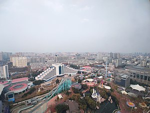
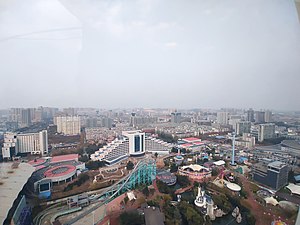
Weifang
Prefecture-level city in Shandong, People's Republic of China
Distance: Approx. 122 meters
Latitude and longitude: 36.708,119.162
Weifang (simplified Chinese: 潍坊; traditional Chinese: 濰坊; pinyin: Wéifāng) is a prefecture-level city in central Shandong province, People's Republic of China. The city borders Dongying to the northwest, Zibo to the west, Linyi to the southwest, Rizhao to the south, Qingdao to the east, and looks out to the Laizhou Bay to the north. Its population was 9,386,705 at the 2020 census, of whom 3,095,520 lived in the built-up (or metro) area made up of four urban districts (Kuiwen, Weicheng, Hanting and Fangzi) and Changle County largely being urbanized.

Weifang Airport
Airport in Shandong, China
Distance: Approx. 7717 meters
Latitude and longitude: 36.64694444,119.11861111
Weifang Airport (IATA: WEF, ICAO: ZSWF) is an airport in Weifang, Shandong, People’s Republic of China. The airport operator called "Weifang Nanyuan Airport Ltd." but official name called "Weifang Airport".

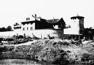
Weixian Internment Camp
WW2 Japanese internment camp for enemy civilians
Distance: Approx. 3221 meters
Latitude and longitude: 36.70222222,119.12638889
The Weixian Internment Camp (Chinese: 濰縣集中營), better known historically as the Weihsien Internment Camp, was a Japanese-run internment camp called a "Civilian Assembly Center" in the former Wei County (濰縣; 潍县; Wéixiàn; Wei2hsien4), located near the city of Weifang, Shandong, China. The compound was used by the Japanese during World War II to intern civilians of Allied countries living in North China. The camp operated from March 1943 until October 1945 and more than 2,200 civilians were interned for all or part of the time the camp was open.

Hanting, Weifang
District in Shandong, People's Republic of China
Distance: Approx. 8162 meters
Latitude and longitude: 36.76972222,119.20916667
Hanting (simplified Chinese: 寒亭区; traditional Chinese: 寒亭區; pinyin: Hántíng Qū) is an urban district of the city of Weifang, Shandong province, China, bordering the Laizhou Bay in its far north.

Fangzi, Weifang
District in Shandong, People's Republic of China
Distance: Approx. 5666 meters
Latitude and longitude: 36.65611111,119.16611111
Fangzi (Chinese: 坊子区; Chinese: 坊子區; pinyin: Fāngzǐ Qū) is a district of the city of Weifang, Shandong province, China. It has an area of 345.55 km2 (133.42 sq mi) and Fangzi District has a household population of 331,100 and a resident population of 362,900(2021).

Kuiwen, Weifang
District in Shandong, People's Republic of China
Distance: Approx. 2588 meters
Latitude and longitude: 36.707,119.133
Kuiwen (Chinese: 奎文; Chinese: 奎文區; pinyin: Kuíwén) is an urban district of the city of Weifang, Shandong province, China. It has an area of 71 km2 (27 sq mi) and according to the Seventh Census, as of 00:00 on November 1, 2020, the resident population of Kuiwan District was 475,103 people.
Weifang Sports Center Stadium
Football stadium in Weifang, China
Distance: Approx. 3607 meters
Latitude and longitude: 36.71704722,119.12361111
Weifang Olympic Sports Centre Stadium was a football stadium in Weifang, China. It hosts football matches and hosted some matches for the women's football competition at the 2009 National Games of China. The stadium holds 45,000 spectators.

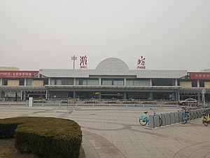
Weifang railway station
Railway station in Weifang, Shandong, China
Distance: Approx. 6369 meters
Latitude and longitude: 36.69606389,119.09192778
The Weifang railway station (simplified Chinese: 潍坊站; traditional Chinese: 濰坊站; pinyin: Wéifāng zhàn) is a railway station in Weicheng District, Weifang, Shandong. It currently lies on the Qingdao–Jinan passenger railway (running CRH and passenger trains) and Qingdao–Jinan railway (running cargo trains and some passenger trains which give ways to CRH).First class seat There is also a branch linking to Fangzi railway station in southern Fangzi District. The city is also served by Weifang North railway station on high-speed lines, however it is located on the northern edge of the urban area.

Weifang World Kite Museum
Museum in Weifang, Shandong, China
Distance: Approx. 4207 meters
Latitude and longitude: 36.70379,119.11502
Weifang World Kite Museum (Chinese: 潍坊世界风筝博物馆) is a museum in the Kuiwen District of Weifang, China. First opened in 1989, it has twelve galleries with models and kites from China's ancient past to modern times and kites from around the world. Weifang is renowned as the "World Capital of Kites".

Dayu Subdistrict, Weifang
Subdistrict in Shandong, People's Republic of China
Distance: Approx. 3826 meters
Latitude and longitude: 36.71972222,119.12222222
Dayu Subdistrict (Chinese: 大虞街道; pinyin: Dàyú Jiēdào) is a subdistrict in Kuiwen District, Weifang, China.
Weather in this IP's area
overcast clouds
13 Celsius
13 Celsius
13 Celsius
13 Celsius
1023 hPa
86 %
1023 hPa
1020 hPa
10000 meters
1.23 m/s
1.56 m/s
19 degree
100 %
06:37:11
16:57:42