103.247.5.41 - IP Lookup: Free IP Address Lookup, Postal Code Lookup, IP Location Lookup, IP ASN, Public IP
Country:
Region:
City:
Location:
Time Zone:
Postal Code:
IP information under different IP Channel
ip-api
Country
Region
City
ASN
Time Zone
ISP
Blacklist
Proxy
Latitude
Longitude
Postal
Route
Luminati
Country
ASN
Time Zone
Asia/Kolkata
ISP
RailTel Corporation of India Ltd
Latitude
Longitude
Postal
IPinfo
Country
Region
City
ASN
Time Zone
ISP
Blacklist
Proxy
Latitude
Longitude
Postal
Route
IP2Location
103.247.5.41Country
Region
maharashtra
City
amravati
Time Zone
Asia/Kolkata
ISP
Language
User-Agent
Latitude
Longitude
Postal
db-ip
Country
Region
City
ASN
Time Zone
ISP
Blacklist
Proxy
Latitude
Longitude
Postal
Route
ipdata
Country
Region
City
ASN
Time Zone
ISP
Blacklist
Proxy
Latitude
Longitude
Postal
Route
Popular places and events near this IP address

Amravati
City in Maharashtra, India
Distance: Approx. 1742 meters
Latitude and longitude: 20.92583333,77.76472222
Amravati is a city in Maharashtra located in the Vidarbha region. It is the ninth largest city in Maharashtra, India & second largest city in the Vidarbha region in terms of population. It is the administrative headquarter of Amravati district as well as Amravati Division which includes Amravati District, Akola District, Buldhana District, Washim District & Yavatmal District.

Berar Province
British Indian province under the nominal sovereignty of Hyderabad State
Distance: Approx. 1852 meters
Latitude and longitude: 20.91666667,77.75
Berar Province, also known as the Hyderabad Assigned Districts, was a province of Hyderabad. After 1853, it was administered by the British, although the Nizam retained formal sovereignty over the province. Azam Jah, the eldest son of the 7th Nizam, held the title of Mirza-Baig ("Prince") of Berar.

Amravati district
District of Maharashtra, India
Distance: Approx. 367 meters
Latitude and longitude: 20.93,77.75
Amravati district (Marathi pronunciation: [əmɾaːʋət̪iː]) is a district of Maharashtra state in central India. It is the administrative headquarter of Amravati division, which is one of the two divisions in Vidarbha (other being Nagpur), out of total 6 regions in state of Maharashtra. The district is situated between 20°32' and 21°46' north latitudes and 76°37' and 78°27' east longitudes.

Amravati division
Place in Maharashtra, India
Distance: Approx. 1852 meters
Latitude and longitude: 20.91666667,77.75
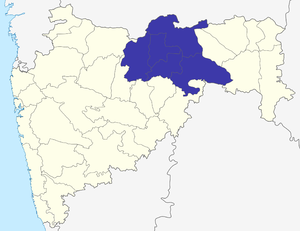
Amravati Division, also known as Varhad, is an Indian one of the six administrative divisions of Maharashtra state in India. Amravati and Nagpur divisions constitute the ancient Vidarbha region. Amravati Division is bound by Madhya Pradesh state to the north, Nagpur Division to the east, Telangana state to the southeast, Marathwada region (Aurangabad Division) to the south and southwest, and Nashik Division to the west.
Government College of Engineering, Amravati
College in Amravati
Distance: Approx. 2935 meters
Latitude and longitude: 20.95856944,77.75803889
Government College of Engineering, Amravati (GCOEA) is an autonomous engineering college affiliated to Sant Gadge Baba Amravati University in Amravati, Maharashtra, India. Established in 1964, it is one of the oldest engineering institutes in state of Maharashtra. Beside engineering education, it is a recognized research center for Ph.D Programs in Civil, Mechanical, Electrical, Electronics and Computer Engineering for Amravati University.

Berar Division
Division of the Central Provinces of British India
Distance: Approx. 1852 meters
Latitude and longitude: 20.91666667,77.75
The Berar Division, formerly Berar Province, was one of the former administrative divisions of the Central Provinces and Berar of British India. Ellichpur (Achalpur) was the capital and the administrative headquarters of the division. The Berar Division had an area of 28,515 km² with a population of 2,672,673 in 1881.

Amravati Lok Sabha constituency
Lok Sabha constituency in Maharashtra
Distance: Approx. 1597 meters
Latitude and longitude: 20.93194167,77.76529167
Amravati Lok Sabha constituency is one of the 48 Lok Sabha (parliamentary) constituencies in Maharashtra state in western India.
Walgaon
Town in Maharashtra, India
Distance: Approx. 8594 meters
Latitude and longitude: 20.99888889,77.70638889
Walgaon is a town in Amravati district in the Indian state of Maharashtra. Samadhi of Gadge Maharaj is located near this town. Its Coordinates are: Coordinates: 20°59'56"N 77°42'23"E .

Amravati Assembly constituency
Constituency of the Maharashtra legislative assembly in India
Distance: Approx. 1597 meters
Latitude and longitude: 20.93194167,77.76529167
Amravati Assembly constituency is one of the 288 constituencies of Maharashtra Vidhan Sabha and one of the eight which are located in the Amravati district. It is a part of the Amravati (Lok Sabha constituency) along with five other Vidhan Sabha assembly constituencies, viz. Badnera, Teosa, Daryapur (SC), Melghat (ST) and Achalpur.

Badnera Assembly constituency
Constituency of the Maharashtra legislative assembly in India
Distance: Approx. 8763 meters
Latitude and longitude: 20.85720833,77.72841389
Badnera is one of the 288 constituencies of Maharashtra Vidhan Sabha and one of the eight which are located in Amravati district. It is a part of the Amravati (Lok Sabha constituency) along with five other Vidhan Sabha assembly constituencies, viz. Amravati, Teosa, Daryapur (SC), Melghat (ST) and Achalpur.
Amravati railway station
Railway station in Maharashtra, India
Distance: Approx. 896 meters
Latitude and longitude: 20.9315,77.7584
Amravati railway station serves Amravati in Amravati district in the Indian state of Maharashtra. It is linked to Badnera railway station on the Howrah–Nagpur–Mumbai line. This is a terminal station.
Hanuman Vyayam Prasarak Mandal
School in Amravati, India, Maharashtra, India
Distance: Approx. 1204 meters
Latitude and longitude: 20.9266935,77.740833
Popularly known as HVPM, this is a premier institute in India for physical training. It was set up by Mr Anant Vaidya and Mr Ambadas Vaidya around 1914. Earlier it was referred as Hanuman Akhada.
Weather in this IP's area
clear sky
19 Celsius
18 Celsius
19 Celsius
19 Celsius
1018 hPa
41 %
1018 hPa
979 hPa
10000 meters
1.21 m/s
1.27 m/s
100 degree