Country:
 USA
USARegion:
City:
Latitude and Longitude:
Time Zone:
Postal Code:
IP information under different IP Channel
ip-api
Country
Region
City
ASN
Time Zone
ISP
Blacklist
Proxy
Latitude
Longitude
Postal
Route
IPinfo
Country
Region
City
ASN
Time Zone
ISP
Blacklist
Proxy
Latitude
Longitude
Postal
Route
MaxMind
Country
Region
City
ASN
Time Zone
ISP
Blacklist
Proxy
Latitude
Longitude
Postal
Route
Luminati
Country
USASN
Time Zone
America/Chicago
ISP
AMAZON-02
Latitude
Longitude
Postal
db-ip
Country
Region
City
ASN
Time Zone
ISP
Blacklist
Proxy
Latitude
Longitude
Postal
Route
ipdata
Country
Region
City
ASN
Time Zone
ISP
Blacklist
Proxy
Latitude
Longitude
Postal
Route
Popular places and events near this IP address

Burlington, Massachusetts
Town in Massachusetts, United States
Distance: Approx. 2515 meters
Latitude and longitude: 42.50472222,-71.19611111
Burlington is a town in Middlesex County, Massachusetts, United States. The population was 26,377 at the 2020 census.

WRKO
Talk radio station in Boston, Massachusetts
Distance: Approx. 1803 meters
Latitude and longitude: 42.490373,-71.217556
WRKO (680 AM) is a commercial news/talk radio station licensed to Boston, Massachusetts, serving Greater Boston and much of surrounding New England. Owned by iHeartMedia, WRKO is a Class B AM station that provides secondary coverage to portions of Massachusetts, Connecticut, Rhode Island, New Hampshire and Maine during the day, but is highly directional at night to protect a number of clear-channel stations on adjacent frequencies. WRKO serves as the Boston affiliate for ABC News Radio, Coast to Coast AM and This Morning, America's First News with Gordon Deal; syndicated personalities Joe Pags, John Batchelor and Bill Cunningham; the flagship station of The Howie Carr Show, and the home of radio personality Jeff Kuhner.
Burlington Mall (Massachusetts)
Shopping mall in Burlington, Massachusetts, United States
Distance: Approx. 1263 meters
Latitude and longitude: 42.48212,-71.21398
Burlington Mall is a shopping mall located in Burlington, Massachusetts. It was opened in 1968. Anchor stores are Nordstrom and Macy's, with one vacant anchor building formerly housing Lord & Taylor.
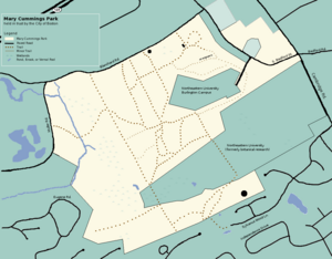
Mary Cummings Park
Public park in Massachusetts, United States
Distance: Approx. 812 meters
Latitude and longitude: 42.4755,-71.1947
Mary Cummings Park is a 216-acre (0.87 km2) public park in Woburn and Burlington, Massachusetts located at Babylon and Whispering Hills. The former farm and estate became a park managed by the City of Boston's Park Department in 1930. Mary Cummings left the land to the City under the condition that it be kept "forever open as a public pleasure ground".

Burlington High School (Massachusetts)
School in Burlington, Massachusetts, United States
Distance: Approx. 1651 meters
Latitude and longitude: 42.497,-71.1973
Burlington High School is a four-year comprehensive high school located at 123 Cambridge Street in Burlington, Massachusetts. It is credited by the New England Association of Schools and Colleges. Burlington High was one of 30 schools in the state of Massachusetts named to the AP Honor Roll by the College Board in 2011 for simultaneously increasing access to Advanced Placement coursework while maintaining or increasing the percentage of students earning scores of 3 or higher on AP exams.

Lahey Hospital & Medical Center
Hospital in Massachusetts, United States
Distance: Approx. 548 meters
Latitude and longitude: 42.4842,-71.2047
The Lahey Hospital & Medical Center, formerly known as the Lahey Clinic, is a physician-led nonprofit teaching hospital of Tufts University School of Medicine based in Burlington, Massachusetts. The hospital was founded in Boston in 1923 by surgeon Frank H. Lahey, M.D., and is managed by Beth Israel Lahey Health. U.S. News & World Report has cited it several times on its list of "America's Best Hospitals" in the category of urology.
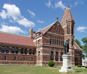
Winn Memorial Library
United States historic place
Distance: Approx. 3598 meters
Latitude and longitude: 42.47888889,-71.155
Woburn Public Library, previously known as the Winn Memorial Library (1876–79) is a National Historic Landmark in Woburn, Massachusetts. Designed by architect H. H. Richardson, the Romanesque Revival building was a bequest of the Winn family. It houses the Woburn Public Library, an institution that was established in 1856.
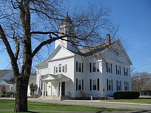
Meeting House of the Second Parish in Woburn
Historic church in Massachusetts, United States
Distance: Approx. 2476 meters
Latitude and longitude: 42.50444444,-71.19888889
The United Church of Christ, Congregational is a historic Congregational church in Burlington, Massachusetts. Built in 1732, it is one of the oldest religious structures in Massachusetts, and one of a small number of pre-19th century church buildings. It was redesigned in 1846 to bring it into the then-popular Greek Revival style, extending it in length and adding a somewhat Gothic-looking steeple.

Center School (Burlington, Massachusetts)
United States historic place
Distance: Approx. 2515 meters
Latitude and longitude: 42.50472222,-71.19611111
The Center School is a historic school building at 13 Bedford Street in Burlington, Massachusetts. The one-room wood-frame schoolhouse was built in 1855, and occupies a prominent place in the center of Burlington. The building is basically Greek Revival in style, with some Italianate features.

West School (Burlington, Massachusetts)
United States historic place
Distance: Approx. 3189 meters
Latitude and longitude: 42.50611111,-71.22
The West School is a historic school building at 106 Bedford Street in Burlington, Massachusetts. The one-room schoolhouse was built in 1794–5, when the area was still part of Woburn. The building was originally located in what is now Simonds Park in the center of Burlington, but was moved to its present location in 1839 to serve as the school for the western part of town.

Willard's Woods
Conservation area in Lexington, Massachusetts
Distance: Approx. 2488 meters
Latitude and longitude: 42.468,-71.222
Willard's Woods is a 100-acre (0.40 km2) conservation area located in Lexington, Massachusetts. It was first founded as a large orchard farm in the 1870s, and has since expanded and become a popular recreational area, with three miles of trails, two streams running through it, a nice boardwalk type path near a pond, a bike path going from opposite ends of the woods, and a variety of plants and wildlife.

Turning Mill / Middle Ridge
Modernist subdivision in Lexington, Massachusetts
Distance: Approx. 2791 meters
Latitude and longitude: 42.48027778,-71.2325
Turning Mill is a residential neighborhood of mid-century modern houses in Lexington, Massachusetts, US.
Weather in this IP's area
clear sky
12 Celsius
12 Celsius
10 Celsius
14 Celsius
1012 hPa
76 %
1012 hPa
1004 hPa
10000 meters
1.34 m/s
2.68 m/s
256 degree
06:17:52
19:07:06