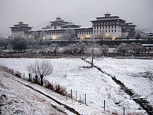
Country:
Region:
City:
Latitude and Longitude:
Time Zone:
Postal Code:
IP information under different IP Channel
ip-api
Country
Region
City
ASN
Time Zone
ISP
Blacklist
Proxy
Latitude
Longitude
Postal
Route
Luminati
Country
ASN
Time Zone
Asia/Thimphu
ISP
DrukNet ISP
Latitude
Longitude
Postal
IPinfo
Country
Region
City
ASN
Time Zone
ISP
Blacklist
Proxy
Latitude
Longitude
Postal
Route
db-ip
Country
Region
City
ASN
Time Zone
ISP
Blacklist
Proxy
Latitude
Longitude
Postal
Route
ipdata
Country
Region
City
ASN
Time Zone
ISP
Blacklist
Proxy
Latitude
Longitude
Postal
Route
Popular places and events near this IP address

Thimphu
Capital and largest city of Bhutan
Distance: Approx. 255 meters
Latitude and longitude: 27.47222222,89.63611111
Thimphu (; Dzongkha: ཐིམ་ཕུག [tʰim˥.pʰu˥]) is the capital and largest city of Bhutan. It is situated in the western central part of Bhutan, and the surrounding valley is one of Bhutan's dzongkhags, the Thimphu District. The ancient capital city of Punakha was replaced by Thimphu as capital in 1955, and in 1961 Thimphu was declared as the capital of the Kingdom of Bhutan by the 3rd Druk Gyalpo Jigme Dorji Wangchuck.

Changlimithang Stadium
Football stadium in Thimphu, Bhutan
Distance: Approx. 243 meters
Latitude and longitude: 27.47141667,89.64105556
Changlimithang Stadium is a multi-purpose stadium in Thimphu, Bhutan, which serves as the national stadium of Bhutan. It is predominantly used for football matches and is the home of the Bhutan national football team, other national selections and a number of Thimphu-based football clubs. The stadium also regularly plays host to women's football, archery tournaments, minifootball and some volleyball matches.

Royal Bhutan Police
Law enforcement agency
Distance: Approx. 736 meters
Latitude and longitude: 27.46519444,89.64044444
The Royal Bhutan Police (Dzongkha: རྒྱལ་གཞུང་འབྲུག་གི་འགག་སྡེ་; gyal-zhung druk-ki gaag-de) is the national police force of the Kingdom of Bhutan. It is responsible for maintaining law and order and prevention of crime in Bhutan. It was formed on 1 September 1965 with 555 personnel reassigned from the Royal Bhutan Army.
Royal Institute of Health Sciences (Bhutan)
Distance: Approx. 778 meters
Latitude and longitude: 27.46472222,89.63722222
The Royal Institute of Health Sciences (RIHS) is one of two main medical education centers in Bhutan, the other being the Institute of Traditional Medicine Services. It was established in Thimphu in 1974, as a member college of the Royal University of Bhutan, and is associated with the National Referral Hospital. It offers diploma and certificate programmes for nurses, medical technicians and other primary health care workers.

Jigme Dorji Wangchuck National Referral Hospital
Hospital in Thimphu, Bhutan
Distance: Approx. 778 meters
Latitude and longitude: 27.46472222,89.63722222
The National Referral Hospital (full name Jigme Dorji Wangchuck National Referral Hospital) is the public hospital of Bhutan, located in the capital of Bhutan, Thimphu. Since it was established in 1972, the hospital has been supplying free basic medical treatment as well as advanced surgeries and emergency services to citizens from all over the country. It provides the most sophisticated health evaluation and management services in the country.
Bhutan Postal Corporation
Operation of postal system in Bhutan
Distance: Approx. 243 meters
Latitude and longitude: 27.47377778,89.63872222
Bhutan Postal Corporation Ltd., often shortened to simply Bhutan Post, is the company in Bhutan responsible for the operation of the country's postal system.

Memorial Chorten, Thimphu
Place of worship and meditation in Bhutan
Distance: Approx. 586 meters
Latitude and longitude: 27.46638889,89.63777778
The Memorial Stupa, Thimphu, also known as the Thimphu Chorten, is a stupa (Dzongkha chöten, cheten) in Thimphu, Bhutan, located on Doeboom Lam in the southern-central part of the city near the main roundabout and Indian military hospital. The stupa, built in 1974 to honor the third Druk Gyalpo, Jigme Dorji Wangchuck (1928–1972), is a prominent landmark in the city with its golden spires and bells. In 2008, it underwent extensive renovation.
Royal Academy of Performing Arts
Bhutanese government body
Distance: Approx. 945 meters
Latitude and longitude: 27.48,89.64
The Royal Academy of Performing Arts (RAPA) is a Bhutanese government body within the Ministry of Home and Cultural Affairs, Department of Culture, that supports the preservation of traditional Bhutanese culture. It was founded in 1954 under the initiative of the Third Druk Gyalpo Jigme Dorji Wangchuck. In 1967, it was institutionalised as an academy and the Royal Dance troupe was its creation.

Clock Tower Square
Town center of Thimphu
Distance: Approx. 181 meters
Latitude and longitude: 27.4703,89.6397
Clock Tower Square is a square in Thimphu, Bhutan, and is the site of the famous tower with four clock faces. There are also many shops, hotels and restaurants surrounding the square.
Centenary and Coronation Park
Distance: Approx. 400 meters
Latitude and longitude: 27.47106,89.6426
In 2005, King Jigme Singye Wangchuck stepped down from the throne to make way for his Son Jigme Khesar Namgyal Wangchuck to lead the kingdom of Bhutan. The new king studied in Britain and various universities in the US. The Coronation and Centenary Park was built to honour our new king. Ashi Chimi Yangzom Wangchuck inaugurated the Centenary and Coronation Park on 26 September 2006.

Royal Textile Academy of Bhutan
Distance: Approx. 889 meters
Latitude and longitude: 27.479228,89.635941
The Royal Textile Academy of Bhutan (རྒྱལ་འཛིན་ཐགས་རིགས་སློབ་སྡེ་) was founded to preserve and promote the living art of weaving which is an important part of the culture and tradition of Bhutan. Under the patronage of Her Majesty Ashi Sangay Choden Wangchuck, it is a non-government, non-profit organization established as an educational center for the training of individuals in traditional Bhutanese weaving. It is a first institution in a country practicing and imparting global methods and techniques of conservation and preservation of the priceless textiles and other artifacts.
Thimphu Athletics Track and Field Centre
Distance: Approx. 897 meters
Latitude and longitude: 27.46508333,89.64394444
The Thimphu Athletics Track and Field Centre is an athletics track in Thimphu, Bhutan. It is the first synthetic athletics track in Bhutan.
Weather in this IP's area
few clouds
5 Celsius
4 Celsius
5 Celsius
5 Celsius
1021 hPa
86 %
1021 hPa
773 hPa
10000 meters
1.35 m/s
1.72 m/s
292 degree
20 %
06:24:38
17:08:55