Country:
Region:
City:
Latitude and Longitude:
Time Zone:
Postal Code:
IP information under different IP Channel
ip-api
Country
Region
City
ASN
Time Zone
ISP
Blacklist
Proxy
Latitude
Longitude
Postal
Route
Luminati
Country
ASN
Time Zone
Pacific/Fiji
ISP
Vodafone Fiji Limited
Latitude
Longitude
Postal
IPinfo
Country
Region
City
ASN
Time Zone
ISP
Blacklist
Proxy
Latitude
Longitude
Postal
Route
db-ip
Country
Region
City
ASN
Time Zone
ISP
Blacklist
Proxy
Latitude
Longitude
Postal
Route
ipdata
Country
Region
City
ASN
Time Zone
ISP
Blacklist
Proxy
Latitude
Longitude
Postal
Route
Popular places and events near this IP address

Suva
Capital and largest city of Fiji
Distance: Approx. 2855 meters
Latitude and longitude: -18.1416,178.4419
Suva (Fijian pronunciation: [ˈsuβa]; Fiji Hindi: सुवा) is the capital and the most populous city of Fiji. It is the home of the country's largest metropolitan area and serves as its major port. The city is located on the southeast coast of the island of Viti Levu, in Rewa Province, Central Division.
Nabua, Fiji
Distance: Approx. 2046 meters
Latitude and longitude: -18.11666667,178.45833333
Nabua (Fijian pronunciation: [naᵐbua]) is a suburb of the Fijian capital of Suva. The Queen Elizabeth Barracks, a major military base which saw a mutiny on 2 November 2000, is located there. Nabua was established in 1935 by the late Ratu Sir Josefa Vanayaliyali Sukuna after the great Tsunami heat in Suva.

Lami, Fiji
Urban area in Rewa Province, Fiji
Distance: Approx. 2364 meters
Latitude and longitude: -18.11666667,178.41666667
Lami (Fijian pronunciation: [lami]), is an urban area in Rewa Province, Fiji, north-west of the capital Suva. It was formally incorporated as a town in 1977, and had a population of 20,529 at the most recent census in 2007. The municipal boundaries enclose an area of 683 square kilometers.

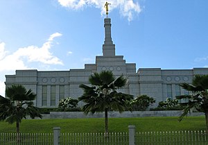
Suva Fiji Temple
Distance: Approx. 406 meters
Latitude and longitude: -18.11972222,178.43855556
The Suva Fiji Temple is the 91st operating temple of the Church of Jesus Christ of Latter-day Saints (LDS Church). The intent to build the temple was announced on April 5, 1998, by church president Gordon B. Hinckley during the church's general conference. The temple is the first to be built in Fiji.

Roman Catholic Archdiocese of Suva
Roman Catholic archdiocese in Fiji
Distance: Approx. 2017 meters
Latitude and longitude: -18.1333,178.433
The Roman Catholic Archdiocese of Suva (Latin: Archidioecesis Suvana) is a Metropolitan Archdiocese in Fiji. It is responsible for the suffragan dioceses of Rarotonga and Tarawa and Nauru and —as of 21 March 2003—the Mission Sui Iuris of Funafuti. The archdiocese was created in 1966, to succeed the Apostolic Vicariate of Fiji.
Fiji School of Medicine
Medical school in Suvi, Fiji
Distance: Approx. 2058 meters
Latitude and longitude: -18.13440556,178.43625
The Fiji School of Medicine is a tertiary institution based in Suva, Fiji. Originally established in 1885 as the Suva Medical School. FSM became the College of Medicine, Nursing & Health Sciences as part of Fiji National University in 2010.
Mahatma Gandhi Memorial High School (Fiji)
Secondary School in Fiji
Distance: Approx. 2332 meters
Latitude and longitude: -18.124664,178.459119
Mahatma Gandhi Memorial High School (M.G.M) is a secondary school institution in Fiji. It is named formally after Mohandas Karamchand Gandhi, a political leader and activist of India during the late 1800s and early 1900s. It was established in 1960 and is managed by the Gujarat Education Society of Fiji.

Fiji National University
Distance: Approx. 2855 meters
Latitude and longitude: -18.1416,178.4419
Fiji National University is a public university in Fiji that was formally constituted on 15 February 2010 under the Fiji National University Act 2009. By 2019, student numbers at the University had grown to almost 27,000. While each of the colleges has its own campus, the University also has two out-reach campuses in Ba and Labasa, which offer a range of programmes from different colleges, supported by distance learning, to broaden access to higher education across the country.

Colonial War Memorial Hospital
Hospital in Suva, Fiji
Distance: Approx. 2150 meters
Latitude and longitude: -18.13472222,178.43361111
The Colonial War Memorial Hospital is a district general hospital located in Suva, Fiji. It was built and completed at the end of 1923. It was built with the assistance of £319,500.

Sacred Heart Cathedral, Suva
Church in Suva, Fiji
Distance: Approx. 2856 meters
Latitude and longitude: -18.1416,178.442
The Sacred Heart Cathedral or simply Cathedral of Suva, is the main ecclesiastical building of the Roman Catholic Church in the island nation of Fiji, and is located on Pratt Street in the City of Suva, Fiji's capital. Suva Cathedral was built in 1902 with sandstone brought from quarries near Sydney, Australia. Its architecture is inspired by the churches of Rome in Italy.
St Joseph's Secondary School, Fiji
All-girls school in Suva, Fiji
Distance: Approx. 1692 meters
Latitude and longitude: -18.1311,178.4364
St Joseph's Secondary School is an all-girls school located in Suva, Fiji. The school was founded in 1956 and has established itself as one of the top schools around the country, progressing in the fields of academics and sports.
Royal Suva Yacht Club
Distance: Approx. 1215 meters
Latitude and longitude: -18.12298,178.430084
Royal Suva Yacht Club is a Fijian yacht club, located in Walu Bay, Suva, Fiji. The yacht club was originally established in 1932, as the Suva Yacht Club, located between Stinson Jetty and Nubukalou Creek along Suva's foreshore before the land was reclaimed. The first flag officers at the club were Commodore T. M. McGuire, Vice Commodore E. E. McGowan and Rear Commodore F. Reay.
Weather in this IP's area
overcast clouds
26 Celsius
26 Celsius
26 Celsius
26 Celsius
1013 hPa
73 %
1013 hPa
1003 hPa
10000 meters
2.57 m/s
140 degree
100 %
05:24:44
18:14:59