Country:
 USA
USARegion:
City:
Latitude and Longitude:
Time Zone:
Postal Code:
IP information under different IP Channel
ip-api
Country
Region
City
ASN
Time Zone
ISP
Blacklist
Proxy
Latitude
Longitude
Postal
Route
IPinfo
Country
Region
City
ASN
Time Zone
ISP
Blacklist
Proxy
Latitude
Longitude
Postal
Route
MaxMind
Country
Region
City
ASN
Time Zone
ISP
Blacklist
Proxy
Latitude
Longitude
Postal
Route
Luminati
Country
USRegion
il
City
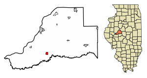
sherman
ASN
Time Zone
America/Chicago
ISP
CASSCOMM
Latitude
Longitude
Postal
db-ip
Country
Region
City
ASN
Time Zone
ISP
Blacklist
Proxy
Latitude
Longitude
Postal
Route
ipdata
Country
Region
City
ASN
Time Zone
ISP
Blacklist
Proxy
Latitude
Longitude
Postal
Route
Popular places and events near this IP address
Kilbourne, Illinois
Village in Illinois, United States
Distance: Approx. 1377 meters
Latitude and longitude: 40.15194444,-90.01138889
Kilbourne is a village in Mason County, Illinois, United States. The population was 265 at the 2020 census, down from 302 in 2010.

Oakford, Illinois
Village in Illinois, United States
Distance: Approx. 7260 meters
Latitude and longitude: 40.10083333,-89.96527778
Oakford is a village in Menard County, Illinois, United States. The population was 234 at the 2020 census, down from 286 in 2010. It is part of the Springfield, Illinois Metropolitan Statistical Area.

Illinois's 18th congressional district
U.S. House district for Illinois
Distance: Approx. 9490 meters
Latitude and longitude: 40.22722222,-90.06916667
The 18th congressional district of Illinois covered central and western Illinois, including all of Jacksonville and Quincy and parts of Bloomington, Peoria, and Springfield. It covered much of the territory represented by Abraham Lincoln during his single term in the House. It was last represented by Republican Darin LaHood, who took office in September 2015 following a special election.

Oakford No. 9 Precinct, Menard County, Illinois
Precinct in Illinois, United States
Distance: Approx. 7184 meters
Latitude and longitude: 40.10833333,-89.95
Oakford No. 9 Precinct is located in Menard County, Illinois. The population was 488 at the 2000 census.

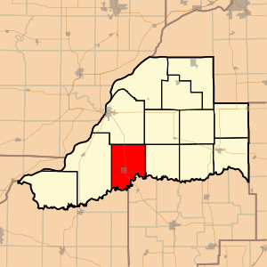
Bath Township, Mason County, Illinois
Township in Illinois, United States
Distance: Approx. 9776 meters
Latitude and longitude: 40.15583333,-90.11444444
Bath Township is located in Mason County, Illinois. As of the 2010 census, its population was 866 and it contained 475 housing units.
Kilbourne Township, Mason County, Illinois
Township in Illinois, United States
Distance: Approx. 688 meters
Latitude and longitude: 40.16666667,-90.00027778
Kilbourne Township is located in Mason County, Illinois. As of the 2010 census, its population was 504 and it contained 245 housing units.
Bobtown, Illinois
Unincorporated community in Illinois, United States
Distance: Approx. 9446 meters
Latitude and longitude: 40.07611111,-89.98805556
Bobtown is an unincorporated community in Menard County, Illinois, United States. Bobtown is 2 miles (3.2 km) southwest of Oakford. The Robinson-Bonnett Inn, which is listed on the National Register of Historic Places, is located in Bobtown.

Robinson-Bonnett Inn
United States historic place
Distance: Approx. 9536 meters
Latitude and longitude: 40.07527778,-89.98833333
The Robinson-Bonnett Inn is a historic inn located on Whites Crossing Road in Bobtown, Illinois. The inn was built circa 1843 by the Robinson family, which ran a gristmill and sawmill in the area, and John Bonnett. The inn was designed in the Federal style and is typical of inns of its period.
Sand Prairie-Scrub Oak State Nature Preserve
State park in Illinois, United States
Distance: Approx. 6950 meters
Latitude and longitude: 40.172,-90.08
The Sand Prairie-Scrub Oak State Nature Preserve, formerly called the Mason County State Wildlife Refuge and Recreation Area, is a State Natural Area and Nature Preserve located in the U.S. state of Illinois. Containing 1,460 acres (591 ha), it is a dedicated state nature preserve. It is located in western Mason County.
Havana Regional Airport
Distance: Approx. 7205 meters
Latitude and longitude: 40.22277778,-90.02277778
The Havana Regional Airport (9I0) is a publicly owned public-use general aviation airport located 5 miles southeast of Havana, Illinois. The closest major airport to Havana is Peoria's General Downing International.
Weather in this IP's area
broken clouds
30 Celsius
28 Celsius
29 Celsius
30 Celsius
1016 hPa
24 %
1016 hPa
999 hPa
10000 meters
4.09 m/s
5.01 m/s
102 degree
70 %
06:42:22
19:07:09