Country:
 USA
USARegion:
City:
Latitude and Longitude:
Time Zone:
Postal Code:
IP information under different IP Channel
ip-api
Country
Region
City
ASN
Time Zone
ISP
Blacklist
Proxy
Latitude
Longitude
Postal
Route
IPinfo
Country
Region
City
ASN
Time Zone
ISP
Blacklist
Proxy
Latitude
Longitude
Postal
Route
MaxMind
Country
Region
City
ASN
Time Zone
ISP
Blacklist
Proxy
Latitude
Longitude
Postal
Route
Luminati
Country
USRegion
il
City
mountsterling
ASN
Time Zone
America/Chicago
ISP
CASSCOMM
Latitude
Longitude
Postal
db-ip
Country
Region
City
ASN
Time Zone
ISP
Blacklist
Proxy
Latitude
Longitude
Postal
Route
ipdata
Country
Region
City
ASN
Time Zone
ISP
Blacklist
Proxy
Latitude
Longitude
Postal
Route
Popular places and events near this IP address
Brown County, Illinois
County in Illinois, United States
Distance: Approx. 3582 meters
Latitude and longitude: 39.95,-90.75
Brown County is a county located in the U.S. state of Illinois. As of the 2020 census, the population was 6,244. Its county seat is Mount Sterling.
Mount Sterling, Illinois
City in Illinois, United States
Distance: Approx. 2505 meters
Latitude and longitude: 39.98666667,-90.76527778
Mount Sterling is a city in and the county seat of Brown County, Illinois, United States. The population was 2,006 at the 2020 census. Foodservice distributor Dot Foods is based in Mount Sterling.

Mount Sterling Township, Brown County, Illinois
Township in Illinois, United States
Distance: Approx. 1301 meters
Latitude and longitude: 39.97277778,-90.74833333
Mount Sterling Township is one of nine townships in Brown County, Illinois, USA. As of the 2020 census, its population was 4,297 and it contained 1,268 housing units.

Ripley Township, Brown County, Illinois
Township in Illinois, United States
Distance: Approx. 8368 meters
Latitude and longitude: 40.02611111,-90.65888889
Ripley Township is one of nine townships in Brown County, Illinois, USA. As of the 2020 census, its population was 70 and it contained 44 housing units.
Brown County Community Unit School District 1
School district in Illinois, United States
Distance: Approx. 1269 meters
Latitude and longitude: 39.9825,-90.75166667
Brown County Community Unit School District 1 is a unified school district located in Mount Sterling, the county seat of Brown County, Illinois; it was created out of sixty-seven individual school districts and one parochial school. Today, the district has three schools: Brown County Elementary School, Brown County Middle School, and Brown County High School. The current superintendent is Vicki Phillips, and the mascot of the school is the Hornet.
Gilbirds, Illinois
Unincorporated community in Illinois, United States
Distance: Approx. 7090 meters
Latitude and longitude: 39.92305556,-90.70138889
Gilbirds is an unincorporated community in Brown County, Illinois, United States. Gilbirds is located on Illinois Route 99, northwest of Versailles.
Hersman, Illinois
Unincorporated community in Illinois, United States
Distance: Approx. 3424 meters
Latitude and longitude: 39.95,-90.74111111
Hersman is an unincorporated community in Brown County, Illinois, United States. Hersman is located on Illinois Route 99, southeast of Mount Sterling.
Brown County High School (Illinois)
Comprehensive public high school in Mt. Sterling, Brown County, Illinois, USA
Distance: Approx. 1307 meters
Latitude and longitude: 39.983,-90.752
Brown County High School, or BCHS, is a public four-year high school located at 500 East Main Street in Mount Sterling, Illinois, a small city in Brown County, Illinois, in the Midwestern United States. BCHS serves the communities of Mount Sterling, Ripley, Timewell, and Versailles. The campus is located 40 miles (64 km) east of Quincy, Illinois, and serves a mixed small city, village, and rural residential community.
Mount Sterling Commercial Historic District
Historic district in Illinois, United States
Distance: Approx. 2428 meters
Latitude and longitude: 39.98638889,-90.76444444
The Mount Sterling Commercial Historic District is a historic business district located in downtown Mount Sterling, Illinois. The district, located immediately south of the Brown County Courthouse, includes four entire city blocks and parts of four others; 38 buildings, of which 35 are contributing buildings, are in the district. Nearly all of the buildings in the district are Italianate commercial buildings; the only exceptions are a Classical Revival bank building and the courthouse, which incorporates both Italianate and Classical Revival elements.
Western Illinois Correctional Center
Distance: Approx. 2336 meters
Latitude and longitude: 39.962368,-90.75055
The Western Illinois Correctional Center is a medium-security state prison for men located in Mount Sterling, Brown County, Illinois, owned and operated by the Illinois Department of Corrections. The facility was first opened in 1989, and has a working capacity of 2173.
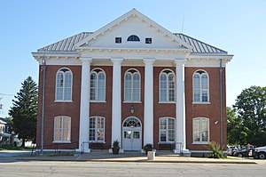
Brown County Courthouse (Illinois)
Local government building in the United States
Distance: Approx. 2414 meters
Latitude and longitude: 39.98666667,-90.76416667
The Brown County Courthouse is a government building in Mount Sterling, the county seat of Brown County, Illinois, United States. Completed in 1868 and rebuilt around 1940, it is the second courthouse in the county's history.
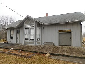
Mount Sterling Municipal Airport
Airport in Brown County, Illinois
Distance: Approx. 5759 meters
Latitude and longitude: 39.98583333,-90.80416667
Mount Sterling Municipal Airport (FAA LID: I63) is a public use airport located 2 miles west of Mount Sterling, Illinois. The airport is publicly owned. The airport sees traffic from Dot Foods and its vendors as well as seasonal hunters, crop dusters, and medevac aircraft.
Weather in this IP's area
clear sky
16 Celsius
15 Celsius
16 Celsius
16 Celsius
1024 hPa
55 %
1024 hPa
999 hPa
10000 meters
06:37:57
19:23:18