Country:
Region:
City:
Latitude and Longitude:
Time Zone:
Postal Code:
IP information under different IP Channel
ip-api
Country
Region
City
ASN
Time Zone
ISP
Blacklist
Proxy
Latitude
Longitude
Postal
Route
Luminati
Country
ASN
Time Zone
Asia/Jakarta
ISP
PT Indonesian Cloud
Latitude
Longitude
Postal
IPinfo
Country
Region
City
ASN
Time Zone
ISP
Blacklist
Proxy
Latitude
Longitude
Postal
Route
db-ip
Country
Region
City
ASN
Time Zone
ISP
Blacklist
Proxy
Latitude
Longitude
Postal
Route
ipdata
Country
Region
City
ASN
Time Zone
ISP
Blacklist
Proxy
Latitude
Longitude
Postal
Route
Popular places and events near this IP address

Siswondo Parman
Indonesian general (1918–1965)
Distance: Approx. 1911 meters
Latitude and longitude: -6.25722222,106.84611111
Lieutenant General Siswondo Parman (4 August 1918 – 1 October 1965) or more popularly known such as in streets name as S. Parman, was a soldier in the Indonesian Army, and was kidnapped from his home in Jakarta by members of the 30 September Movement in the early hours of October 1. He was later killed at Lubang Buaya.

Mas Tirtodarmo Haryono
Indonesian general (1924–1965)
Distance: Approx. 1911 meters
Latitude and longitude: -6.25722222,106.84611111
Lieutenant General Mas Tirtodarmo Haryono (20 January 1924 – 1 October 1965) was a general officer in the Indonesian Army who was killed during an attempt to kidnap him from his home by members of the 30 September Movement in the early hours of 1 October 1965.

Halim Perdanakusuma
Indonesian airman and National Hero of Indonesia
Distance: Approx. 1896 meters
Latitude and longitude: -6.25722222,106.84638889
Air Vice-Marshal Abdul Halim Perdanakusuma (18 November 1922 – 14 December 1947), better known as Halim Perdanakusuma, was an Indonesian airman and National Hero of Indonesia.
Universitas Siswa Bangsa Internasional
University in Indonesia
Distance: Approx. 1266 meters
Latitude and longitude: -6.247814,106.844884
Universitas Siswa Bangsa Internasional (also known by the acronym USBI), or Sampoerna University, is an international university located in Jakarta, Indonesia. It is the first Indonesian university to offer an accredited U.S. degree entirely within Indonesia.
2017 Jakarta bombings
Terrorist attacks in Jakarta, Indonesia
Distance: Approx. 1503 meters
Latitude and longitude: -6.22932222,106.85205
On 24 May 2017, two explosions occurred at a bus terminal in Kampung Melayu, East Jakarta. Police confirmed that the explosions were caused by multiple explosive devices found in the toilet and in another part of the terminal. The bombings killed five people: three policemen and two attackers.

Dirgantara Monument
Monument in Jakarta, Indonesia
Distance: Approx. 1277 meters
Latitude and longitude: -6.243085,106.843472
Dirgantara Monument (Indonesian: Monumen Patung Dirgantara), also known as Gatot Kaca Monument after the Javanese wayang figure, is a monument located in Jakarta, Indonesia. It is also known as Tugu Pancoran, after tugu a word for statue and pedestal, and the South Jakarta subdistrict of Pancoran, where it is located. The monument was commissioned by President Sukarno in 1964 as a tribute to the Indonesian Air Force and early Indonesian aviators who flew against the Dutch to achieve independence.

Baru Barat River
River in Jakarta, Indonesia
Distance: Approx. 1531 meters
Latitude and longitude: -6.2347,106.8436
The Baru Barat River (Indonesian: Kali Baru Barat, lit. 'Western New River') is a man-made canal flowing from the Cisadane River in Bogor Regency to Jakarta, Indonesia. It was one of two canals built in the 18th century under the order of the Governor-General Gustaaf Willem van Imhoff, the other being the Baru Timur River (Indonesian: Kali Baru Timur, lit. 'Eastern New River'). Both canals were originally built to transport agricultural harvests from Bogor to Batavia (now Jakarta).

Tebet Eco Park
Urban park in Tebet, Jakarta, Indonesia
Distance: Approx. 628 meters
Latitude and longitude: -6.237329,106.852728
The Tebet Eco Park (Indonesian: Taman Eco Tebet) or Taman Kota Tebet is an urban park located in Tebet, Jakarta, Indonesia. The park has a land area of 7 hectares and it was previously known as Tebet Honda Park. It is a popular place for exercise, socialization, and recreation for neighboring community.

Cawang railway station
Railway station in Indonesia
Distance: Approx. 339 meters
Latitude and longitude: -6.24189,106.858
Cawang Station (CW) is a class II railway station located at Jl. Tebet Timur Dalam 11, East Tebet, Tebet, South Jakarta, Indonesia. The station, which is located at the altitude of +26 meters, is included in Operational Area I Jakarta of Kereta Api Indonesia and only serves the KRL Commuterline route.

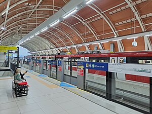
Pancoran Bank BJB LRT Station
LRT station in Indonesia
Distance: Approx. 1830 meters
Latitude and longitude: -6.24212721,106.8384693
Pancoran LRT Station (or Pancoran Bank BJB LRT Station, with Bank BJB granted for naming rights) is a light rail station located in Jalan Gatot Subroto, Pancoran, Pancoran, South Jakarta. The station, which is located at an altitude of +38.510 meters, serves the Cibubur and Bekasi lines of the Jabodebek LRT system.

Cikoko LRT Station
Distance: Approx. 257 meters
Latitude and longitude: -6.243476,106.857102
Cikoko LRT Station is a light rail station located in Jalan Cikoko Barat, Cikoko, Pancoran, South Jakarta. The station, which is located at an altitude of +39.53 meters, serves the Cibubur and Bekasi lines of the Jabodebek LRT system.

Ciliwung LRT Station
Railway station in Indonesia
Distance: Approx. 1016 meters
Latitude and longitude: -6.243477,106.864131
Ciliwung LRT Station is a light rail station located in Jalan Letjen M.T. Haryono, Cawang, Kramat Jati, East Jakarta. The station, which is located at an altitude of +36.34 meters, serves the Cibubur and Bekasi lines of the Jabodebek LRT system.
Weather in this IP's area
haze
26 Celsius
27 Celsius
25 Celsius
26 Celsius
1007 hPa
93 %
1007 hPa
1005 hPa
5000 meters
20 %
05:25:36
17:50:12