Country:
Region:
City:
Latitude and Longitude:
Time Zone:
Postal Code:
IP information under different IP Channel
ip-api
Country
Region
City
ASN
Time Zone
ISP
Blacklist
Proxy
Latitude
Longitude
Postal
Route
Luminati
Country
ASN
Time Zone
Asia/Seoul
ISP
EAGLE SKY CO LT
Latitude
Longitude
Postal
IPinfo
Country
Region
City
ASN
Time Zone
ISP
Blacklist
Proxy
Latitude
Longitude
Postal
Route
db-ip
Country
Region
City
ASN
Time Zone
ISP
Blacklist
Proxy
Latitude
Longitude
Postal
Route
ipdata
Country
Region
City
ASN
Time Zone
ISP
Blacklist
Proxy
Latitude
Longitude
Postal
Route
Popular places and events near this IP address

Aeogae station
Station of the Seoul Metropolitan Subway
Distance: Approx. 976 meters
Latitude and longitude: 37.55344444,126.95666667
Aeogae station (Korean: 애오개; lit. Small ridge) is a subway station on Line 5 of the Seoul Metropolitan Subway. The station is located in the Ahyeon neighborhood of Mapo District, Seoul.
Hyochang Stadium
Stadium in Seoul, South Korea
Distance: Approx. 854 meters
Latitude and longitude: 37.54352222,126.96134444
Hyochang Stadium (Korean: 효창운동장; Hanja: 孝昌運動場) is a multi-purpose stadium in Hyochang-dong, Yongsan District, Seoul, South Korea. It is currently used mostly for football matches. The stadium has a capacity of 15,194 people.
Seoul Girls' High School
Public school in Seoul, South Korea
Distance: Approx. 397 meters
Latitude and longitude: 37.5478116,126.9485819
Seoul Girls' High School (서울여자고등학교) is a high school located in Yeomni-dong, Mapo district, Seoul. It was established in 1958 as Mapo Girls' High School, and took its present name in 1960. The school was divided into separate junior high and high schools in 1968.

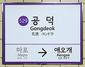
Gongdeok station
Train station in South Korea
Distance: Approx. 283 meters
Latitude and longitude: 37.54305556,126.95111111
Gongdeok Station is a subway station on Seoul Subway Line 5, Line 6, AREX and the Gyeongui–Jungang Line. Gongdeok Market, near Exit 4 of the station, is on the Seoul list of Asia's 10 greatest street food cities for the haemulpajeon.

Daeheung station
Train station in South Korea
Distance: Approx. 899 meters
Latitude and longitude: 37.54777778,126.94222222
Daeheung station is a subway station on Seoul Subway Line 6 in Seoul, South Korea.

Mapo station
Train station in South Korea
Distance: Approx. 827 meters
Latitude and longitude: 37.53972222,126.94611111
Mapo Station is a station on Seoul Subway Line 5 in Mapo-gu, Seoul. It is located close to the northeastern end of the Mapo Bridge.

Kim Koo Museum
Museum in Seoul, South Korea
Distance: Approx. 677 meters
Latitude and longitude: 37.54414,126.95948
The Kim Koo Museum (Korean: 백범김구기념관; lit. Paekpŏm Kim Ku Memorial Hall) is a museum in located within Hyochang Park, Hyochang-dong, Yongsan District, Seoul, South Korea. It commemorates the life and work of Kim Ku (also spelled "Kim Koo"), a Korean independence activist during the Japanese occupation of Korea.
Gongdeok-dong
Place in South Korea
Distance: Approx. 461 meters
Latitude and longitude: 37.5464,126.9571
Gongdeok-dong (Korean: 공덕동) is a legal dong (neighborhood) of Mapo District, Seoul, South Korea. Gongdeok-dong is governed by its administrative dong, the office of Cheonyeon-dong.
Chung Young Yang Embroidery Museum
Museum in Seoul, South Korea
Distance: Approx. 1071 meters
Latitude and longitude: 37.5448,126.9641
The Chung Young Yang Embroidery Museum (Korean: 정영양 자수 박물관) is a textile museum in Seoul, South Korea. It was founded by Dr. Young Yang Chung and inaugurated in May 2004 by Sookmyung Women's University.

Hyochang Park
Park in Seoul, South Korea
Distance: Approx. 806 meters
Latitude and longitude: 37.545,126.96111111
Hyochang Park (Korean: 효창공원) is a park in Yongsan District, Seoul, South Korea. The park is near Exit 1 of the Hyochang Park station of the Seoul Metropolitan Subway. Popular for leisure and exercise, the park has walking paths, sports facilities, forests, and cherry blossom trees.

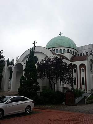
St. Nicholas Cathedral (Seoul)
Church in Seoul, South Korea
Distance: Approx. 801 meters
Latitude and longitude: 37.55138889,126.95722222
St. Nicholas Cathedral (Korean: 정교회 성 니콜라스 대성당) is the main cathedral of the Metropolis of Korea. It is located in Ahyeon-dong, Mapo District, Seoul, South Korea.
Mapo Ok
Korean restaurant in Seoul, South Korea
Distance: Approx. 996 meters
Latitude and longitude: 37.5399,126.9432
Mapo Ok (Korean: 마포옥; RR: Mapook) is a historic Korean restaurant in Mapo District, Seoul, South Korea. The restaurant first opened in 1949, and specializes in the beef soup dish seolleongtang. Since 2020, the restaurant has been listed on the Michelin Guide as a Bib Gourmand restaurant.
Weather in this IP's area
clear sky
8 Celsius
7 Celsius
7 Celsius
10 Celsius
1029 hPa
49 %
1029 hPa
1026 hPa
10000 meters
2.57 m/s
330 degree
07:16:13
17:19:15

