Country:
 Indonesia
Region:
City:
Latitude and Longitude:
Time Zone:
Postal Code:
IP information under different IP Channel
ip-api
Country
Region
City
ASN
Time Zone
ISP
Blacklist
Proxy
Latitude
Longitude
Postal
Route
IPinfo
Country
Region
City
ASN
Time Zone
ISP
Blacklist
Proxy
Latitude
Longitude
Postal
Route
MaxMind
Country
Region
City
ASN
Time Zone
ISP
Blacklist
Proxy
Latitude
Longitude
Postal
Route
Luminati
Country
IDASN
Time Zone
Asia/Jakarta
ISP
PT Parsaoran Global Datatrans
Latitude
Longitude
Postal
db-ip
Country
Region
City
ASN
Time Zone
ISP
Blacklist
Proxy
Latitude
Longitude
Postal
Route
ipdata
Country
Region
City
ASN
Time Zone
ISP
Blacklist
Proxy
Latitude
Longitude
Postal
Route
Popular places and events near this IP address
South Bekasi
District in West Java, Indonesia
Distance: Approx. 2930 meters
Latitude and longitude: -6.25555556,106.96861111
South Bekasi (Indonesian: Bekasi Selatan) is one of the twelve administrative districts (kecamatan) within the municipality of Bekasi, in Jabodetabek (Jakarta's metropolitan area) on the island of Java, Indonesia. The district covers an area of 1,581 hectares (3,907 acres), and had a population of 203,654 at the 2010 Census and 210,805 at the 2020 Census; the official estimate as at mid 2023 was 214,493 - comprising 106,105 malkes and 108,388 females. The administrative centre is located in Pekayon Jaya, and the district is sub-divided into five urban "villages" or communities (kelurahan), as listed below with their areas, their populations as at the 2020 Census and th official estimates as at mid 2023, together with their postcodes.
Jati Bening Baru LRT Station
LRT station in Indonesia
Distance: Approx. 2397 meters
Latitude and longitude: -6.257775,106.927679
Jati Bening Baru LRT Station is a light rail station located in Jalan Kapin Raya, Jatibening Baru, Pondokgede, Bekasi. The station, which is located at an altitude of +37 meters, serves the Bekasi line of the Jabodebek LRT system. It is the line's westernmost station located in city of Bekasi.
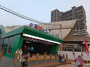
Cikunir 1 LRT Station
LRT station in Indonesia
Distance: Approx. 1551 meters
Latitude and longitude: -6.25624,106.950998
Cikunir 1 LRT Station is a light rail station located in Jalan Caman Raya, Jatibening, Pondokgede, Bekasi. The station, which is located at an altitude of +38.51 meters, serves the Bekasi line of the Jabodebek LRT system.

Cikunir 2 LRT Station
LRT station in Indonesia
Distance: Approx. 2528 meters
Latitude and longitude: -6.254512,106.963378
Cikunir 2 LRT Station is a light rail station located in Jalan Batu Mulia, Jakasampurna, Bekasi Barat, Bekasi. The station, which is located at an altitude of +38.55 meters, serves the Bekasi line of the Jabodebek LRT system.
East Bekasi
District in West Java, Indonesia
Distance: Approx. 2930 meters
Latitude and longitude: -6.25555556,106.96861111
East Bekasi (Indonesian: Bekasi Timur) is one of the twelve administrative districts (kecamatan) within the municipality of Bekasi, in Jabodetabek (Jakarta's metropolitan area) on the island of Java, Indonesia. The district covers an area of 1,464 hectares (3,618 acres), and had a population of 247,357 at the 2010 Census and 257,025 at the 2020 Census; the official estimate as at mid 2023 was 273,703 - comprising 136,428 males and 137,275. The administrative centre is located in Bekasi Jaya, and the district is sub-divided into four urban "villages" or communities (kelurahan), as listed below with their areas and their populations as at mid 2023, together with their postcodes.
West Bekasi
District in West Java, Indonesia
Distance: Approx. 2930 meters
Latitude and longitude: -6.25555556,106.96861111
West Bekasi (Indonesian: Bekasi Barat) is one of the twelve administrative districts (kecamatan) within the municipality of Bekasi, in Jabodetabek (Jakarta's metropolitan area) on the island of Java, Indonesia. The district covers an area of 1,490 hectares (3,682 acres), and had a population of 272,557 at the 2010 Census and 281,681 at the 2020 Census; the official estimate as at mid 2023 was 266,287 - comprising 133,054 males and 133,233 females. The administrative centre is located in Bintara, and the district is sub-divided into five urban "villages" or communities (kelurahan), as listed below with their areas and their populations as at mid 2023, together with their postcodes.
Medansatria
District in West Java, Indonesia
Distance: Approx. 2930 meters
Latitude and longitude: -6.25555556,106.96861111
Medansatria or Medan Satria is one of the twelve administrative districts (kecamatan) within the city municipality of Bekasi, in Jabodetabek (Jakarta's metropolitan area) on the island of Java, Indonesia. The district covers an area of 1,321 hectares (3,264 acres), and had a population of 161,121 at the 2010 Census and 162,119 at the 2020 Census; the official estimate as at mid 2023 was 158,729 - comprising 79,840 males and 78,889 females. The administrative centre is located in Medansatria kelurahan, and the district is sub-divided into four urban "villages" or communities (kelurahan), as listed below with their areas and their populations as at mid 2023, together with their postcodes.
Rawalumbu
District in West Java, Indonesia
Distance: Approx. 2930 meters
Latitude and longitude: -6.25555556,106.96861111
Rawalumbu is one of the twelve administrative districts (kecamatan) within the city municipality of Bekasi, in Jabodetabek (Jakarta's metropolitan area) on the island of Java, Indonesia. The district covers an area of 1,685 hectares (4,164 acres), and had a population of 208,334 at the 2010 Census and 220,699 at the 2020 Census; the official estimate as at mid 2023 was 222,398 - comprising 111,408 males and 110,990 females. The administrative centre is located in Bojong Rawalumbu, and the district is sub-divided into four urban "villages" or communities (kelurahan), as listed below with their areas and their populations as at mid 2023, together with their postcodes.
Bantargebang
District in West Java, Indonesia
Distance: Approx. 2930 meters
Latitude and longitude: -6.25555556,106.96861111
Bantargebang is one of the twelve administrative districts (kecamatan) within the city municipality of Bekasi, in Jabodetabek (Jakarta's metropolitan area) on the island of Java, Indonesia. The district covers an area of 1,924 hectares (4,754 acres), and had a population of 95,845 at the 2010 Census and 107,216 at the 2020 Census; the official estimate as at mid 2023 was 113,988 - comprising 58,047 males and 55,941 females. The administrative centre is located in Bantargebang kelurahan, and the district is sub-divided into four urban "villages" or communities (kelurahan), as listed below with their areas and their populations as at mid 2023, together with their postcodes.
Pondok Gede, Bekasi
District in West Java, Indonesia
Distance: Approx. 2930 meters
Latitude and longitude: -6.25555556,106.96861111
Pondok Gede or Pondokgede is one of the twelve administrative districts (kecamatan) within the city municipality of Bekasi, in Jabodetabek (Jakarta's metropolitan area) on the island of Java, Indonesia. The district covers an area of 1,743 hectares (4,307 acres), and had a population of 246,503 at the 2010 Census and 251,195 at the 2020 Census; the official estimate as at mid 2023 was 227,423 - comprising 117,443 males and 113,980 females. The administrative centre is located in Jati Waringin, and the district is sub-divided into five urban "villages" or communities (kelurahan), as listed below with their areas and their populations as at mid 2023, together with their postcodes.
Jatisampurna, Bekasi
District in West Java, Indonesia
Distance: Approx. 2930 meters
Latitude and longitude: -6.25555556,106.96861111
Jatisampurna is one of the twelve administrative districts (kecamatan) within the city municipality of Bekasi, in Jabodetabek (Jakarta's metropolitan area) on the island of Java, Indonesia. The district covers an area of 2,019 hectares (4,989 acres), and had a population of 103,715 at the 2010 Census and 123,924 at the 2020 Census; the official estimate as at mid 2023 was 114,108 - comprising 56,912 males and 57,196 females. The administrative centre is located in Jatisampurna kelurahan, and the district is sub-divided into five urban "villages" or communities (kelurahan), as listed below with their areas and their populations as at mid 2023, together with their postcodes.
Pondok Melati, Bekasi
District in West Java, Indonesia
Distance: Approx. 2930 meters
Latitude and longitude: -6.25555556,106.96861111
Pondok Melati is one of the twelve administrative districts (kecamatan) within the city municipality of Bekasi, in Jabodetabek (Jakarta's metropolitan area) on the island of Java, Indonesia. The district covers an area of 1,102 hectares (2,723 acres), and had a population of 128,934 at the 2010 Census and 131,122 at the 2020 Census; the official estimate as at mid 2023 was 128,690 - comprising 64,295 males and 64,395 females.mid 2023 estimate The administrative centre is located in Jati Rahayu, and the district is sub-divided into four urban "villages" or communities (kelurahan), as listed below with their areas and their populations as at mid 2023, together with their postcodes.
Weather in this IP's area
few clouds
35 Celsius
37 Celsius
33 Celsius
36 Celsius
1008 hPa
38 %
1008 hPa
1005 hPa
7000 meters
5.14 m/s
240 degree
20 %
05:28:49
17:44:51