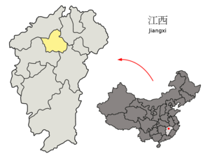
Country:
 Chinese mainland
Region:
City:
Latitude and Longitude:
Time Zone:
Postal Code:
IP information under different IP Channel
ip-api
Country
Region
City
ASN
Time Zone
ISP
Blacklist
Proxy
Latitude
Longitude
Postal
Route
IPinfo
Country
Region
City
ASN
Time Zone
ISP
Blacklist
Proxy
Latitude
Longitude
Postal
Route
MaxMind
Country
Region
City
ASN
Time Zone
ISP
Blacklist
Proxy
Latitude
Longitude
Postal
Route
Luminati
Country
CNASN
Time Zone
Asia/Shanghai
ISP
CHINA UNICOM China169 Backbone
Latitude
Longitude
Postal
db-ip
Country
Region
City
ASN
Time Zone
ISP
Blacklist
Proxy
Latitude
Longitude
Postal
Route
ipdata
Country
Region
City
ASN
Time Zone
ISP
Blacklist
Proxy
Latitude
Longitude
Postal
Route
Popular places and events near this IP address
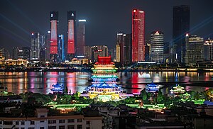
Nanchang
Capital of Jiangxi, China
Distance: Approx. 24 meters
Latitude and longitude: 28.683,115.858
Nanchang is the capital of Jiangxi, China. Located in the north-central part of the province and in the hinterland of Poyang Lake Plain, it is bounded on the west by the Jiuling Mountains, and on the east by Poyang Lake. Because of its strategic location connecting the prosperous East and South China, it has become a major railway hub in Southern China in recent decades.
Battle of Nanchang
Distance: Approx. 2465 meters
Latitude and longitude: 28.68333333,115.88333333
The Battle of Nanchang (simplified Chinese: 南昌会战; traditional Chinese: 南昌會戰) was a military campaign fought around Nanchang, Jiangxi between the Chinese National Revolutionary Army and the Japanese Imperial Japanese Army in the Second Sino-Japanese War. It was the first major conflict to occur following the Battle of Wuhan.

Donghu, Nanchang
District in Jiangxi, People's Republic of China
Distance: Approx. 3823 meters
Latitude and longitude: 28.679,115.897
Donghu District (simplified Chinese: 东湖区; traditional Chinese: 東湖區; pinyin: Dōnghú Qū; lit. 'east lake district') is one of 6 urban districts of the prefecture-level city of Nanchang, the capital of Jiangxi Province, China. The district was created in the Tang dynasty when a bridge was built across Nanchang's Taihu lake, dividing the area into the East and West Lake districts.
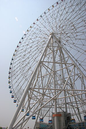
Star of Nanchang
Ferris wheel in Jiangxi, China
Distance: Approx. 2885 meters
Latitude and longitude: 28.659332,115.845568
The Star of Nanchang (Chinese: 南昌之星 or simplified Chinese: 南昌之星摩天轮; traditional Chinese: 南昌之星摩天輪) is a 160-meter (525 ft)-tall Ferris wheel located in the eastern Chinese city of Nanchang, the capital of Jiangxi Province. The Star of Nanchang opened for business in May 2006, having cost 57 million yuan (roughly $7.3 million) to build. Formerly the world's tallest Ferris wheel, it was succeeded by the 165-meter (541 ft)-tall Singapore Flyer which officially opened to the public on March 1, 2008.
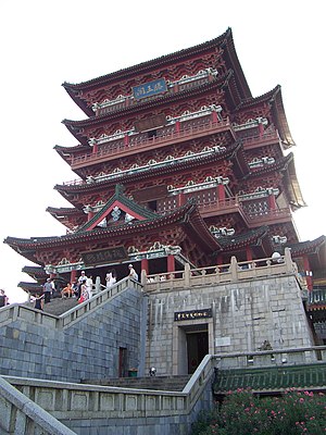
Pavilion of Prince Teng
Tower in Nanchang, China
Distance: Approx. 1735 meters
Latitude and longitude: 28.6841,115.8758
The Pavilion of Prince Teng (traditional Chinese: 滕王閣; simplified Chinese: 滕王阁; pinyin: Téngwáng Gé) is a building in the North West of the city of Nanchang, in Jiangxi province, China, on the east bank of the Gan River and is one of the Three Great Towers of southern China. The other two are the Yueyang Tower and the Yellow Crane Pavilion. It has been destroyed and rebuilt many times over its history.
Bayi Square
Distance: Approx. 4112 meters
Latitude and longitude: 28.67722222,115.89972222
Bayi Square (Chinese: 八一广场; pinyin: Bāyī Guǎngchǎng; lit. 'Aug. 1st Square') in Nanchang, Jiangxi, China was built from August 1, 1977, to January 8, 1979, in memory of Nanchang Uprising (aka.
Xihu, Nanchang
District of Nanchang, Jiangxi, China
Distance: Approx. 3369 meters
Latitude and longitude: 28.6576,115.8772
Xihu District (Chinese: 西湖区; pinyin: Xīhú Qū), literally meaning "west lake district", is one of six urban districts of the prefecture-level city of Nanchang, the capital of Jiangxi Province, China. The district was created in the Tang dynasty when a bridge was built across Nanchang's Taihu lake, dividing the area into the East and West Lake districts. It covers over 39 square kilometers and as of 2004 had a population of 460,000.
Roman Catholic Archdiocese of Nanchang
Roman Catholic archdiocese in China
Distance: Approx. 3936 meters
Latitude and longitude: 28.6718,115.8964
The Roman Catholic Archdiocese of Nanchang (Latin: Nanciamen(sis), Chinese: 南昌) is an archdiocese based in the city of Nanchang in China.

Xinjian, Nanchang
District in Jiangxi, People's Republic of China
Distance: Approx. 4328 meters
Latitude and longitude: 28.6929,115.8153
Xinjian (Chinese: 新建区; pinyin: Xīnjiàn Qū) is one of 6 urban districts of the prefecture-level city of Nanchang, the capital of Jiangxi Province, China, located on the western (left) bank of the Gan River. It consists of two disjoint sections to the north and south of Wanli and Qingshanhu districts. In 1999 it had a population of 643,535.

Nanchang International School
Primary, international school in China
Distance: Approx. 2119 meters
Latitude and longitude: 28.6991,115.8469
Nanchang International School (NCIS; simplified Chinese: 南昌国际学校; traditional Chinese: 南昌國際學校; pinyin: Nánchāng Guójì Xuéxiào) is an international primary school in Nanchang, Jiangxi Province, People's Republic of China. Nanchang International School was established in August 2010 and is the first English-speaking international school in Jiangxi Province to be approved as an international school by the Chinese Ministry of Education. Matthew Bristow was the Founding Principal.
Honggutan, Nanchang
District in Jiangxi, People's Republic of China
Distance: Approx. 2435 meters
Latitude and longitude: 28.70388889,115.86472222
Honggutan District (Chinese: 红谷滩区; pinyin: Hónggǔtān qū) is a district of Nanchang, the capital of Jiangxi Province, China. It covers over 175 square kilometers and had a population of 600,000.

Chinese destroyer Nanchang (163)
Type 051 destroyer of the PLA Navy
Distance: Approx. 5130 meters
Latitude and longitude: 28.7217757,115.8861323
Nanchang (163) is a Type 051 destroyer of the People's Liberation Army Navy.
Weather in this IP's area
overcast clouds
30 Celsius
35 Celsius
30 Celsius
30 Celsius
1007 hPa
68 %
1007 hPa
1005 hPa
10000 meters
4.98 m/s
7.2 m/s
2 degree
100 %
06:03:30
18:17:22