Country:
 Indonesia
Region:
City:
Latitude and Longitude:
Time Zone:
Postal Code:
IP information under different IP Channel
ip-api
Country
Region
City
ASN
Time Zone
ISP
Blacklist
Proxy
Latitude
Longitude
Postal
Route
IPinfo
Country
Region
City
ASN
Time Zone
ISP
Blacklist
Proxy
Latitude
Longitude
Postal
Route
MaxMind
Country
Region
City
ASN
Time Zone
ISP
Blacklist
Proxy
Latitude
Longitude
Postal
Route
Luminati
Country
IDASN
Time Zone
Asia/Jakarta
ISP
PT Arsenet Global Solusi
Latitude
Longitude
Postal
db-ip
Country
Region
City
ASN
Time Zone
ISP
Blacklist
Proxy
Latitude
Longitude
Postal
Route
ipdata
Country
Region
City
ASN
Time Zone
ISP
Blacklist
Proxy
Latitude
Longitude
Postal
Route
Popular places and events near this IP address

East Nusa Tenggara
Province of Indonesia
Distance: Approx. 2463 meters
Latitude and longitude: -10.18333333,123.58333333
East Nusa Tenggara (Indonesian: Nusa Tenggara Timur) is the southernmost province of Indonesia. It comprises the eastern portion of the Lesser Sunda Islands, facing the Indian Ocean in the south and the Flores Sea in the north. It consists of more than 500 islands, with the largest ones being Sumba, Flores, and the western part of Timor; the latter shares a land border with the separate nation of East Timor.

Kupang
City and capital of East Nusa Tenggara, Indonesia
Distance: Approx. 637 meters
Latitude and longitude: -10.17016667,123.60775
Kupang (Indonesian: Kota Kupang, Indonesian pronunciation: [ˈkupaŋ]), formerly known as Koepang or Coupang, is the capital of the Indonesian province of East Nusa Tenggara. At the 2020 Census, it had a population of 442,758; the official estimate as of mid-2023 was 466,632 (comprising 234,963 males and 231,669 females). It is the largest city and port on the island of Timor, and is a part of the Timor Leste–Indonesia–Australia Growth Triangle free trade zone.
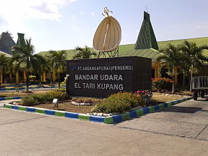
El Tari Airport
Airport in Kupang, East Nusa Tenggara, Indonesia
Distance: Approx. 7573 meters
Latitude and longitude: -10.17138889,123.67111111
El Tari Airport (IATA: KOE, ICAO: WATT) — formerly Penfui Airport — is a domestic airport in Kupang on the island of Timor in the province of East Nusa Tenggara, Indonesia. The airport is named after El Tari (1926–1978), the governor of East Nusa Tenggara from 1966 to 1978. The airport's ICAO code was changed from WRKK to WATT in 2004.
Roman Catholic Archdiocese of Kupang
Roman Catholic archdiocese in East Nusa Tenggara, Indonesia
Distance: Approx. 2492 meters
Latitude and longitude: -10.1833,123.583
The Roman Catholic Metropolitan Archdiocese of Kupang (Latin: Kupangensis) is an archdiocese located in the city of Kupang, East Nusa Tenggara province in Indonesia.

University of Nusa Cendana
University in Kupang, Indonesia
Distance: Approx. 6512 meters
Latitude and longitude: -10.1545227,123.6590252
The University of Nusa Cendana (Indonesian: Universitas Nusa Cendana) is a public university in Kupang, East Nusa Tenggara, Indonesia. It was established on September 1, 1962. Its rector is Maxs Sanam.
Artha Wacana Christian University
University in Kupang, Indonesia
Distance: Approx. 6130 meters
Latitude and longitude: -10.149231,123.65339
The Artha Wacana Christian University (UKAW or Universitas Kristen Artha Wacana) is a private university located in Kupang, East Nusa Tenggara, Indonesia.
Usapa Besar
Distance: Approx. 8567 meters
Latitude and longitude: -10.132036,123.669425
Usapa Besar was a military camp built by Sparrow Force in the defence of Timor in 1942. After capitulation, the Japanese Army converted the camp to hold Sparrow Force as prisoners of war.
Battle of Penfui
Took place on 9 November 1749 in the hillside of Penfui, near modern Kupang
Distance: Approx. 6174 meters
Latitude and longitude: -10.167,123.6582
The Battle of Penfui took place on 9 November 1749 in the hillside of Penfui, near modern Kupang. A large Topass army was defeated by a numerically inferior Dutch East India Company force following the withdrawal of the former's Timorese allies from the battlefield, resulting in the death of the Topass leader Gaspar da Costa. Following the battle, both Topass and Portuguese influence on Timor declined, eventually leading to the formation of a boundary between Dutch and Portuguese Timor which precipitated into the modern border between West Timor and East Timor.
Weather in this IP's area
light rain
31 Celsius
36 Celsius
31 Celsius
31 Celsius
1011 hPa
62 %
1011 hPa
1001 hPa
10000 meters
2.57 m/s
230 degree
40 %
05:19:16
17:41:11