Country:
Region:
City:
Latitude and Longitude:
Time Zone:
Postal Code:
IP information under different IP Channel
ip-api
Country
Region
City
ASN
Time Zone
ISP
Blacklist
Proxy
Latitude
Longitude
Postal
Route
Luminati
Country
ASN
Time Zone
Asia/Shanghai
ISP
CHINA UNICOM China169 Backbone
Latitude
Longitude
Postal
IPinfo
Country
Region
City
ASN
Time Zone
ISP
Blacklist
Proxy
Latitude
Longitude
Postal
Route
db-ip
Country
Region
City
ASN
Time Zone
ISP
Blacklist
Proxy
Latitude
Longitude
Postal
Route
ipdata
Country
Region
City
ASN
Time Zone
ISP
Blacklist
Proxy
Latitude
Longitude
Postal
Route
Popular places and events near this IP address

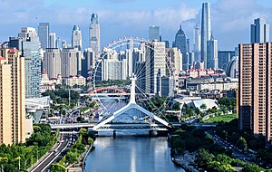
Tianjin
Municipality of China
Distance: Approx. 1366 meters
Latitude and longitude: 39.1336,117.2054
Tianjin is a direct-administered municipality in Northern China on the shore of the Bohai Sea. It is one of the nine national central cities, with a total population of 13,866,009 inhabitants at the time of the 2020 Chinese census. Its metropolitan area, which is made up of 12 central districts (other than Baodi, Jizhou, Jinghai and Ninghe), was home to 11,165,706 inhabitants and is also the world's 29th-largest agglomeration (between Chengdu and Rio de Janeiro) and 11th-most populous city proper.

Roman Catholic Diocese of Tianjin
Roman Catholic diocese in China
Distance: Approx. 665 meters
Latitude and longitude: 39.1333,117.183
The Roman Catholic Diocese of Tianjin/Tíentsín (Latin:Latin: Tienzinen(sis), Chinese: 天津; pinyin: Tiānjīn) is a suffragan diocese in the ecclesiastical province of the Metropolitan Archbishop of Beijing in PR China. Its cathedral episcopal see is Cathedral of St. Joseph (Laoxikai Church), in the city of Tianjin, which also houses the former cathedral Our Lady of Victory Church (Wanghailou Church) (圣母得勝堂(望海樓天主堂)).
Tianjin World Financial Center
Supertall skyscraper in Tianjin, China
Distance: Approx. 591 meters
Latitude and longitude: 39.12888889,117.19638889
The Tianjin Tower, or Jin Tower (Chinese: 津塔; pinyin: Jīntǎ), or Tianjin World Financial Center (Chinese: 天津环球金融中心; pinyin: Tiānjīn Huánqiú Jīnróng Zhōngxīn) is a modern supertall skyscraper located in the Heping District of Tianjin, China, on the banks of the Hai River. The mixed-use tower is 336.9 meters (1,105 ft) tall and contains 74 floors above ground and 4 below, with an observation deck at 305.2 meters (1,001 ft). The area of the glass unitized curtain wall, manufactured by Jangho Group, is 215,000m².

Tianjin railway station
Principal railway station in Tianjin, China
Distance: Approx. 1209 meters
Latitude and longitude: 39.13472222,117.20305556
Tianjin railway station (Chinese: 天津站; pinyin: Tiānjīn Zhàn) is the principal railway station in Tianjin, China. It was established in 1888, rebuilt in 1987–1988, and restructured in 2007–2008. Its Chinese big title was written by Deng Xiaoping in 1988, for celebrating 100th anniversary of its founding.

Guwenhua Jie
Pedestrian tourist area of Tianjin, China
Distance: Approx. 1295 meters
Latitude and longitude: 39.1422,117.193
Guwenhua Jie, Tianjin's Ancient Culture Street, is a pedestrian pathway complex dotted with temple gates and kiosks on the west bank of the Hai River in Tianjin, China. The Nankai District area is classified as a AAAAA scenic area by the China National Tourism Administration. Tianjin Ancient Culture Street was opened on New Year's Day in 1986.

Italian concession of Tianjin
Small Territory controlled by the Kingdom of Italy
Distance: Approx. 576 meters
Latitude and longitude: 39.135,117.1939
The Italian concession of Tianjin (Chinese: 天津意租界; pinyin: Tiānjīn Yì Zūjiè, Italian: Concessione italiana di Tientsin) was a small territory (concession) in central Tianjin (formerly romanized as Tientsin), China, controlled by the Kingdom of Italy between 1901 and 1943, officially ceded to China in 1947.
Dongnanjiao station
Metro station in Tianjin, China
Distance: Approx. 746 meters
Latitude and longitude: 39.1357,117.1841
Dongnanjiao station (Chinese: 东南角站), is a station of Line 2 and Line 4 of the Tianjin Metro. It started operations on 1 July 2012.

Quanyechang Subdistrict
Subdistrict in Tianjin, China
Distance: Approx. 1030 meters
Latitude and longitude: 39.1225,117.19527778
Quanyechang Subdistrict (simplified Chinese: 劝业场街道; traditional Chinese: 勸業場街道; pinyin: Quànyèchǎng Jiēdào) is a subdistrict located within Heping District, Tianjin. it shares border with Guangfudao Subdistrict in its north, Xiaobailou Subdistrict in its east, Nanyingmen Subdistrict in its south, as well as Xingnan and Nanshi Subdistricts in its west. In 2010, it had a total population of 59,551.

Nanshi Subdistrict, Tianjin
Subdistrict in Tianjin, China
Distance: Approx. 829 meters
Latitude and longitude: 39.1275,117.18138889
Nanshi Subdistrict (Chinese: 南市街道; pinyin: Nánshì Jiēdào) is a subdistrict situated on the northwestern part of Heping District, Tianjin. it borders Gulou Subdistrict to its north, Guangfudao Subdistrict to its east, Quanyechang Subdistrict to its south, and Xingnan Subdistrict to its west. It had 33,874 inhabitants under its administration as of 2010.

Garden of Serenity
Museum
Distance: Approx. 1132 meters
Latitude and longitude: 39.1223,117.1828
The Garden of Serenity or Jingyuan (靜園) is a museum and former residence of Puyi, the last emperor of China in Tianjin, China.

Zhang Garden
Mansion in Tianijn, China
Distance: Approx. 871 meters
Latitude and longitude: 39.123991,117.18503
The Zhang Garden or Zhangyuan (張園) is a European-style former garrison building in Tianijn, China built in the 1930s. Prior to construction of the garrison building the site contained a mansion residence, built in 1916 in the Japanese Concession of Tianjin by Zhang Biao, a former high-ranking official in the Qing Court.
Termination of the German and Austro-Hungarian Legations
Distance: Approx. 1366 meters
Latitude and longitude: 39.1336,117.2054
After the sinking of the SS Athos and the severing of diplomatic ties with the Central Powers, The Republic Of China decided to officially declare war and liquidate the German Empire and Austro-Hungarian Empire's Legations in Peking.
Weather in this IP's area
mist
9 Celsius
9 Celsius
9 Celsius
9 Celsius
1025 hPa
93 %
1025 hPa
1024 hPa
3000 meters
1 m/s
11 %
06:49:57
17:00:42

