Country:
Region:
City:
Latitude and Longitude:
Time Zone:
Postal Code:
IP information under different IP Channel
ip-api
Country
Region
City
ASN
Time Zone
ISP
Blacklist
Proxy
Latitude
Longitude
Postal
Route
Luminati
Country
ASN
Time Zone
Asia/Hong_Kong
ISP
China Unicom Global
Latitude
Longitude
Postal
IPinfo
Country
Region
City
ASN
Time Zone
ISP
Blacklist
Proxy
Latitude
Longitude
Postal
Route
db-ip
Country
Region
City
ASN
Time Zone
ISP
Blacklist
Proxy
Latitude
Longitude
Postal
Route
ipdata
Country
Region
City
ASN
Time Zone
ISP
Blacklist
Proxy
Latitude
Longitude
Postal
Route
Popular places and events near this IP address

Kowloon Park
Park in Tsim Sha Tsui, Hong Kong
Distance: Approx. 288 meters
Latitude and longitude: 22.30143,114.16986
Kowloon Park is a large public park in Tsim Sha Tsui, Kowloon, Hong Kong. It has an area of 13.3 hectares (33 acres) and is managed by the Leisure and Cultural Services Department.

Harbour City (Hong Kong)
Shopping centre in Tsim Sha Tsui, Hong Kong
Distance: Approx. 231 meters
Latitude and longitude: 22.2975,114.16861111
Harbour City is a shopping centre in Tsim Sha Tsui, Kowloon, Hong Kong. It occupies the lower levels of a series of office blocks and hotels, comprising several parts: Marco Polo Hotels, Ocean Terminal, Ocean Centre, the Gateway and the Pacific Club Kowloon. The complex is located along the west side of Canton Road, stretching from Star House and the Star Ferry Pier in the south to China Hong Kong City in the north.
Whitfield Barracks
Barracks in Tsim Sha Tsui, Kowloon, Hong Kong
Distance: Approx. 183 meters
Latitude and longitude: 22.299321,114.16977
Whitfield Barracks were barracks in Tsim Sha Tsui, Kowloon, Hong Kong. It was named after Henry Wase Whitfield, who was appointed commander of the British Army in Hong Kong in 1869. The area is now the site of Kowloon Park, where four reconverted barrack blocks and parts of the former Kowloon West II Battery remain.

China Hong Kong City
Building complex in Tsim Sha Tsui, Hong Kong
Distance: Approx. 101 meters
Latitude and longitude: 22.30038,114.16777
China Hong Kong City (Chinese: 中港城; Jyutping: zung1 gong2 seng4; pinyin: Zhōng Gǎng Chéng) is a commercial complex that includes five office towers, a shopping centre, a hotel and a ferry terminal in Tsim Sha Tsui, Kowloon, Hong Kong. The complex opened in 1988 on land formerly occupied in part by the Royal Naval Dockyard (subsequently Government Dockyard) and the Sea Terminus (demolished 1969). It is situated along Canton Road, next to The Gateway and the Tsim Sha Tsui Fire Station.

The Gateway, Hong Kong
Distance: Approx. 195 meters
Latitude and longitude: 22.29776,114.16825
The Gateway (Chinese: 港威大廈; Jyutping: gong2 wai1 daai6 haa6), part of Harbour City, is the office buildings with shopping arcade at lower level in Tsim Sha Tsui, Kowloon, Hong Kong.

Hong Kong China Ferry Terminal
Pier in Kowloon, Hong Kong
Distance: Approx. 80 meters
Latitude and longitude: 22.29931,114.16725
Hong Kong China Ferry Terminal is a ferry terminal, located at China Hong Kong City, 33 Canton Road, Tsim Sha Tsui, Kowloon, Hong Kong. It is one of three cross-border ferry terminals in Hong Kong. The pier has operated since 8 October 1988.
Tsim Sha Tsui Fire Station
Fire station in Kowloon, Hong Kong
Distance: Approx. 200 meters
Latitude and longitude: 22.301269,114.167684
Tsim Sha Tsui Fire Station is a fire station in Tsim Sha Tsui, Kowloon, Hong Kong. The station stands at the Canton Road, adjacent to China Hong Kong City. The front door of the station was styled with old style fire alarm lights and guarded by a pair of lion statues.

Lai Chack Middle School
Secondary school in Hong Kong
Distance: Approx. 233 meters
Latitude and longitude: 22.301545,114.168497
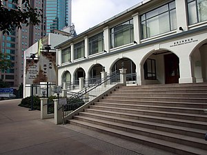
Lai Chack Middle School (Chinese: 麗澤中學) is a secondary school in Tsim Sha Tsui, Kowloon, Hong Kong. Founded in 1929, it started as a girls' school in Wan Chai and a branch in Jordan Road. With various relocation in its history, its secondary school section finally settled in the current premises at No.

Haiphong Road
Road in Tsim Sha Tsui, Hong Kong
Distance: Approx. 292 meters
Latitude and longitude: 22.2981,114.1704
Haiphong Road is a road south of Kowloon Park, Tsim Sha Tsui, Hong Kong. The road links Canton Road and Nathan Road.

Hong Kong Heritage Discovery Centre
Distance: Approx. 177 meters
Latitude and longitude: 22.2993,114.1697
The Hong Kong Heritage Discovery Centre is a public cultural center located in the Kowloon Park, Haiphong Road, Tsim Sha Tsui, Kowloon, Hong Kong. The Centre occupies the historic Blocks S61 and S62 of the former Whitfield Barracks at the Kowloon Park.

Victoria Towers
Residential in Tsim Sha Tsui, Hong Kong
Distance: Approx. 324 meters
Latitude and longitude: 22.30238,114.16848
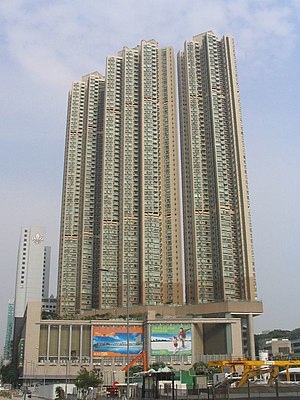
The Victoria Towers (Chinese: 港景峰; Jyutping: gong2 ging2 fung1) are a high-rise residential development located in the Tsim Sha Tsui area of Hong Kong. The complex consists of three towers, each rising 62 floors and 213 metres (699 ft) in height. The complex is located at No.188 Canton Road, at the intersection with Austin Road and was designed by Rocco Design Architects Limited and developed by Cheung Kong Holdings and Hutchison Whampoa Properties.
Fok Tak Temple
Distance: Approx. 293 meters
Latitude and longitude: 22.297734,114.170109
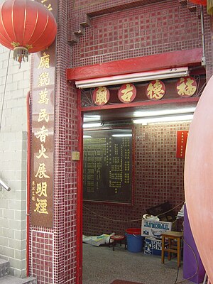
Fok Tak Temple (Chinese: 福德古廟; Jyutping: fuk1 dak1 gu2 miu6) is the only Chinese temple in Tsim Sha Tsui, Kowloon, Hong Kong. It is located on Haiphong Road and the current structure dates back to the year 1900. The temple was renovated in 1979 and 1993.
Weather in this IP's area
broken clouds
24 Celsius
25 Celsius
23 Celsius
25 Celsius
1016 hPa
79 %
1016 hPa
1016 hPa
10000 meters
4.92 m/s
40 degree
72 %
06:37:45
17:39:33


