103.234.203.107 - IP Lookup: Free IP Address Lookup, Postal Code Lookup, IP Location Lookup, IP ASN, Public IP
Country:
Region:
City:
Location:
Time Zone:
Postal Code:
ISP:
ASN:
language:
User-Agent:
Proxy IP:
Blacklist:
IP information under different IP Channel
ip-api
Country
Region
City
ASN
Time Zone
ISP
Blacklist
Proxy
Latitude
Longitude
Postal
Route
db-ip
Country
Region
City
ASN
Time Zone
ISP
Blacklist
Proxy
Latitude
Longitude
Postal
Route
IPinfo
Country
Region
City
ASN
Time Zone
ISP
Blacklist
Proxy
Latitude
Longitude
Postal
Route
IP2Location
103.234.203.107Country
Region
rajshahi
City
thakurgaon
Time Zone
Asia/Dhaka
ISP
Language
User-Agent
Latitude
Longitude
Postal
ipdata
Country
Region
City
ASN
Time Zone
ISP
Blacklist
Proxy
Latitude
Longitude
Postal
Route
Popular places and events near this IP address

Thakurgaon Sadar Upazila
Upazila in Rangpur, Bangladesh
Distance: Approx. 1481 meters
Latitude and longitude: 26.02,88.46666667
Thakurgaon Sadar (Bengali: ঠাকুরগাঁও সদর) is an upazila of Thakurgaon District in the Division of Rangpur, Bangladesh.
Thakurgaon Stadium
Distance: Approx. 1135 meters
Latitude and longitude: 26.02645,88.47510556
Thakurgaon Stadium is located by the Thakurgaon Inter District Bus Terminal, Thakurgaon, Bangladesh.

Thakurgaon Airport
Airport in Bangladesh
Distance: Approx. 6771 meters
Latitude and longitude: 26.01641667,88.40166667
Thakurgaon Airport (IATA: TKR, ICAO: VGSG) was a public and military STOL airport located near Shibganj of Thakurgaon district in northwestern Bangladesh. The airport was established in 1940 on 550 acres. This airstrip was heavily damaged by the Indian Air Force during the Indo-Pakistan War of 1965.
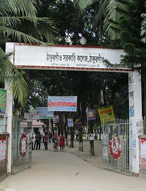
Thakurgaon Government College
Distance: Approx. 1538 meters
Latitude and longitude: 26.0394,88.4529
Thakurgaon Government College is an honors-level degree college in Thakurgaon, Bangladesh. It is situated in Thakurgaon town nearest to the south-east of the Tangon River. From this college, In west Thakurgaon Railway Station and in east Thakurgaon Bus-stand(old) are located.

Thakurgaon, Bangladesh
Municipality in Rangpur, Bangladesh
Distance: Approx. 161 meters
Latitude and longitude: 26.032,88.466
Thakurgaon is a city in northern Bangladesh. It is the headquarters of Thakurgaon District and Thakurgaon Sadar Upazila.# Thakurgaon District Introduction Thakurgaon is a district located in the northern part of Bangladesh, part of the Rangpur Division. Known for its agricultural richness and cultural heritage, Thakurgaon is bordered by India to the north and features a predominantly rural landscape.
Thakurgaon Road railway station
Railway station in Bangladesh
Distance: Approx. 4047 meters
Latitude and longitude: 26.0391632,88.4267702
Thakurgaon Road railway station is a railway serving Thakurgaon. It was built in 1930s. It is 5 km away Thakurgaon town.
Weather in this IP's area
overcast clouds
23 Celsius
22 Celsius
23 Celsius
23 Celsius
1020 hPa
35 %
1020 hPa
1013 hPa
10000 meters
0.96 m/s
1.26 m/s
20 degree
97 %
