Country:
 Hong Kong (China)
Region:
City:
Latitude and Longitude:
Time Zone:
Postal Code:
IP information under different IP Channel
ip-api
Country
Region
City
ASN
Time Zone
ISP
Blacklist
Proxy
Latitude
Longitude
Postal
Route
IPinfo
Country
Region
City
ASN
Time Zone
ISP
Blacklist
Proxy
Latitude
Longitude
Postal
Route
MaxMind
Country
Region
City
ASN
Time Zone
ISP
Blacklist
Proxy
Latitude
Longitude
Postal
Route
Luminati
Country
HKASN
Time Zone
Asia/Hong_Kong
Latitude
Longitude
Postal
db-ip
Country
Region
City
ASN
Time Zone
ISP
Blacklist
Proxy
Latitude
Longitude
Postal
Route
ipdata
Country
Region
City
ASN
Time Zone
ISP
Blacklist
Proxy
Latitude
Longitude
Postal
Route
Popular places and events near this IP address
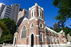
St Andrew's Church, Kowloon
Church in Hong Kong, China
Distance: Approx. 269 meters
Latitude and longitude: 22.3019,114.1724
St Andrew's Church (Chinese: 聖安德烈堂) is located at 138 Nathan Road, Kowloon, Hong Kong. It is a church of the Anglican (Sheng Kung Hui) Province of Hong Kong and in the Diocese of Western Kowloon. It is the oldest English speaking Protestant church in Kowloon.

Observatory Road
Road in Hong Kong
Distance: Approx. 39 meters
Latitude and longitude: 22.30137,114.17486
Observatory Road (Chinese: 天文臺道) is one of the oldest roads in Hong Kong, and has existed since 1883. It is called so because this is where the Hong Kong Observatory was constructed. The Observatory is still in operation and provides updated typhoon information and other services for the Northwest Pacific area.

Gun Club Hill Barracks
Barracks in Hong Kong
Distance: Approx. 252 meters
Latitude and longitude: 22.303,114.177
Gun Club Hill Barracks are barracks in King's Park, or in Jordan, Hong Kong formerly used by British Army garrisons during British colonial rule. The military began using the area shortly after 1860 when the British acquired Kowloon. The barracks are bounded by Austin Road, Jordan Path, Gascoigne Road and Chatham Road South.

St. Mary's Canossian College
Grant, secondary school
Distance: Approx. 202 meters
Latitude and longitude: 22.30306,114.1763
St. Mary's Canossian College (Chinese: 嘉諾撒聖瑪利書院) is a Catholic girls secondary school in Tsim Sha Tsui, Kowloon, Hong Kong. The school was founded in 1900, and is situated at the junction of Austin Road and Chatham Road South.
Observatory Hill (Hong Kong)
Hill in Tsim Sha Tsui, Hong Kong
Distance: Approx. 151 meters
Latitude and longitude: 22.3021,114.1736
Observatory Hill (Chinese: 天文臺山), formerly known as Elgin Hill (伊利近山), is a hill where the Hong Kong Observatory is sited. Observatory Road is a road passing through Royal Observatory Hong Kong from east to west. Both its south slope Knutsford Terrace and north slope Hillwood Road are full of restaurants, pubs and bars.

Knutsford Terrace
Street in Tsim Sha Tsui, Kowloon, Hong Kong
Distance: Approx. 47 meters
Latitude and longitude: 22.30135,114.17475
Knutsford Terrace (Chinese: 諾士佛台) is a terrace street in Tsim Sha Tsui, Kowloon in Hong Kong. It is famous for its bars, pubs and restaurants. On the south slope of Observatory Hill, Knutsford Terrace is hidden behind the buildings of Kimberley Road.

Rosary Church
Distance: Approx. 176 meters
Latitude and longitude: 22.3026,114.1764
Rosary Church is located at 125 Chatham Road South, Tsim Sha Tsui, Kowloon, Hong Kong. It is the oldest Catholic church in Kowloon. The church is in Gothic style; the original plan was based on a Roman Basilican model.

Cameron Road
Road in Hong Kong, China
Distance: Approx. 259 meters
Latitude and longitude: 22.29941,114.17454
Cameron Road (Chinese: 金馬倫道) is a street in Tsim Sha Tsui, Kowloon, Hong Kong.

Granville Road
Street in Hong Kong
Distance: Approx. 174 meters
Latitude and longitude: 22.300195,114.174532
Granville Road (Chinese: 加連威老道) is a street in Tsim Sha Tsui, Hong Kong.

Kimberley Road
Street in Tsim Sha Tsui, Hong Kong
Distance: Approx. 167 meters
Latitude and longitude: 22.30075,114.17375
Kimberley Road (Chinese: 金巴利道) is a road in Tsim Sha Tsui, Kowloon, Hong Kong, China.

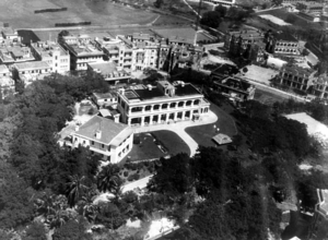
Hong Kong Observatory
Hong Kong meteorological agency
Distance: Approx. 124 meters
Latitude and longitude: 22.3025,114.17416667
The Hong Kong Observatory is a weather forecast agency of the government of Hong Kong. The Observatory forecasts the weather and issues warnings on weather-related hazards. It also monitors and makes assessments on radiation levels in Hong Kong and provides other meteorological and geophysical services to meet the needs of the public and the shipping, aviation, industrial and engineering sectors.

Korean Street, Hong Kong
Ethnic enclave in Hong Kong, China
Distance: Approx. 124 meters
Latitude and longitude: 22.30059,114.17487
Korean Street (Chinese: 韓國街), also known as Little Korea (Chinese: 小韓國), is a Koreatown in Hong Kong located primarily on Kimberley Street in Tsim Sha Tsui. A compact community of Koreans have lived in this area since the 1960s, and there is a concentration of Korean shops opened by Koreans, such as Korean restaurants and grocery stores. There are at least sixteen Korean food shops in Kimberly Street.
Weather in this IP's area
overcast clouds
30 Celsius
37 Celsius
30 Celsius
30 Celsius
1006 hPa
81 %
1006 hPa
1003 hPa
10000 meters
2.68 m/s
110 degree
100 %
06:08:16
18:34:05