Country:
 Vietnam
Region:
City:
Latitude and Longitude:
Time Zone:
Postal Code:
IP information under different IP Channel
ip-api
Country
Region
City
ASN
Time Zone
ISP
Blacklist
Proxy
Latitude
Longitude
Postal
Route
IPinfo
Country
Region
City
ASN
Time Zone
ISP
Blacklist
Proxy
Latitude
Longitude
Postal
Route
MaxMind
Country
Region
City
ASN
Time Zone
ISP
Blacklist
Proxy
Latitude
Longitude
Postal
Route
Luminati
Country
VNRegion
hn
City
hanoi
ASN
Time Zone
Asia/Bangkok
ISP
LeaseWeb Netherlands B.V.
Latitude
Longitude
Postal
db-ip
Country
Region
City
ASN
Time Zone
ISP
Blacklist
Proxy
Latitude
Longitude
Postal
Route
ipdata
Country
Region
City
ASN
Time Zone
ISP
Blacklist
Proxy
Latitude
Longitude
Postal
Route
Popular places and events near this IP address

International Control Commission
1954–1974 United Nations mission in Vietnam, Laos, and Cambodia
Distance: Approx. 189 meters
Latitude and longitude: 21.02833333,105.85416667
The International Control Commission (abbreviated ICC; French: Commission Internationale de Contrôle, or CIC), was an international force established in 1954. More formally called the International Commission for Supervision and Control, the organisation was actually organised as three separate but interconnected bodies, one for each territory within the former French Indochina, being treated as a single state having two temporary administrations: the ICSC for Vietnam; the ICSC for Laos; and the ICSC for Cambodia. It oversaw the implementation of the Geneva Accords that ended the First Indochina War and brought about the Partition of Vietnam.

Hoàn Kiếm Lake
Lake in Hanoi, Vietnam
Distance: Approx. 36 meters
Latitude and longitude: 21.02888889,105.8525
Hoàn Kiếm Lake (Vietnamese: Hồ Hoàn Kiếm, chữ Hán: 湖還劍, meaning "Lake of the Returned Sword" or "Lake of the Restored Sword"), also known as Sword Lake (Hồ Gươm) or Tả Vọng Lake (Hồ Tả Vọng), is a fresh water lake, measuring some 12 ha in the historical center of Hanoi, the capital city of Vietnam. In the past, the lake was variously named "Lục Thủy Lake" (Vietnamese: Hồ Lục Thủy, meaning "Green Water Lake" - aptly named for the water's color) or "Thủy Quân Lake" (Vietnamese: Hồ Thủy Quân, meaning "Mariner's Lake"). The lake is one of the major scenic spots in the city and serves as a focal point for its public life.
State Bank of Vietnam
Central Bank of Vietnam
Distance: Approx. 434 meters
Latitude and longitude: 21.0274,105.8563
The State Bank of Vietnam (SBV; Vietnamese: Ngân hàng Nhà nước Việt Nam) is the central bank of Vietnam. Organized a ministry-level body under the Government of Vietnam, it is the sole issuer of the national currency, the Vietnamese đồng. As of 2024 it holds over USD 100 million in foreign exchange reserves.
Hoàn Kiếm district
Urban district in Hanoi, Vietnam
Distance: Approx. 36 meters
Latitude and longitude: 21.02888889,105.8525
Hoàn Kiếm (transl. Returned Sword) is one of the four original urban districts (quận) of Hanoi, the capital city of Vietnam. It is named after the scenic Hoàn Kiếm Lake. The lake is in the heart of the district and serves as the focal point of the city's public life.

Đại La
Distance: Approx. 189 meters
Latitude and longitude: 21.02833333,105.85416667
Đại La (Chinese: 大羅城; pinyin: Dàluóchéng), means the Citadel of the Great Dike, or La Thành (羅城, means the Citadel of the Dike) was an ancient fortified city in present-day Hanoi during the third Chinese domination of the 7th and 8th centuries, and again in the 11th-century under Lý dynasty. Đại La was constructed by jiedushi Gao Pian in 866. It was the seat of Songping County during the Tang dynasty, and was capital of the Tĩnh Hải quân.

Turtle Tower
Vietnamese tower
Distance: Approx. 148 meters
Latitude and longitude: 21.0279,105.8523
Turtle Tower (Vietnamese: Tháp Rùa / 塔𪛇), also called Tortoise Tower, is a small tower in the middle of Hoan Kiem Lake (Sword Lake) in central Hanoi, Vietnam. It is one of the most iconic, symbolic and most recognizable pieces of architecture representing Hanoi and the entirety of Vietnam.
North Vietnam
Former country in Southeast Asia that existed from 1945 to 1976
Distance: Approx. 189 meters
Latitude and longitude: 21.02833333,105.85416667
North Vietnam, officially the Democratic Republic of Vietnam (DRV; Vietnamese: Việt Nam Dân chủ Cộng hòa; VNDCCH, chữ Nôm: 越南民主共和), was a socialist state in Southeast Asia that existed from 1945 to 1976, with formal sovereignty being fully recognized in 1954. A member of the Eastern Bloc, it opposed the French-supported State of Vietnam and later the Western-allied Republic of Vietnam (South Vietnam). The DRV emerged victorious over South Vietnam in 1975 and ceased to exist the following year when it unified with the south to become the current Socialist Republic of Vietnam.
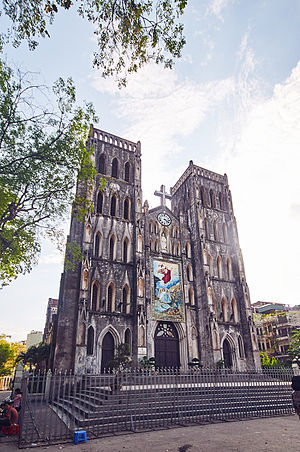
St. Joseph's Cathedral, Hanoi
Church in Vietnam
Distance: Approx. 391 meters
Latitude and longitude: 21.02861111,105.84888889
St. Joseph's Cathedral (Vietnamese: Nhà thờ Lớn Hà Nội lit. 'Grand Cathedral of Hanoi', Nhà thờ Chính tòa Thánh Giuse; French: Cathédrale Saint-Joseph d'Hanoï) is a Catholic church on Nhà Chung Street, in the Hoàn Kiếm District of Hanoi, Vietnam. It is a late 19th-century Gothic Revival (Neo-Gothic style) church that serves as the cathedral of the Roman Catholic Archdiocese of Hanoi.

Ngọc Sơn Temple
Temple in Vietnam
Distance: Approx. 178 meters
Latitude and longitude: 21.0307,105.852
The Ngọc Sơn Temple (Vietnamese: Đền Ngọc Sơn, chữ Nôm: 𪽛玉山) is located on a islet in Hoàn Kiếm Lake, central Hanoi, Vietnam.

National Library of Vietnam
Distance: Approx. 498 meters
Latitude and longitude: 21.02583333,105.84944444
The National Library of Vietnam (Vietnamese: Thư viện Quốc gia Việt Nam; French: Bibliothèque Nationale du Viet Nam) is the national library in Vietnam and it is located in Hanoi. It was established by a decree of 29 November 1917 as the central library of Indochina. In September 1919 the library was made open to the public with an intent to support and promote western archive and library work.
Hanoi Garden
Restaurant in Hanoi, Vietnam
Distance: Approx. 472 meters
Latitude and longitude: 21.03128611,105.84864722
Hanoi Garden is a restaurant in Hanoi, Vietnam. It opened in 1998 on Hang Manh street in the Old Quarter. It serves Vietnamese cuisine with a twist and is quite popular with the local Vietnamese.
Siege of Songping
9th century siege battle in Southeast Asia
Distance: Approx. 189 meters
Latitude and longitude: 21.02833333,105.85416667
The siege of Songping or the siege of Hanoi was the pivotal part of Nanzhao's great offensive in 863. Nanzhao was in alliance with local tribal rebels, against the Tang dynasty who was currently in control of the Red River Delta in modern-day northern Vietnam. The siege took place in Songping (modern-day Hanoi), capital of Tang's frontier Protectorate General to Pacify the South in early 863 during the reign of Emperor Yizong.
Weather in this IP's area
overcast clouds
28 Celsius
30 Celsius
28 Celsius
28 Celsius
1016 hPa
68 %
1016 hPa
1015 hPa
10000 meters
1.74 m/s
3.69 m/s
123 degree
100 %
05:54:09
17:27:57